
Fitxategi:Colonial Africa 1913 map.svg

SVG fitxategi honen PNG aurreikuspenaren tamaina: 644 × 600 pixel. Bestelako bereizmenak: 258 × 240 pixel | 515 × 480 pixel | 824 × 768 pixel | 1.099 × 1.024 pixel | 2.198 × 2.048 pixel | 1.390 × 1.295 pixel.
Bereizmen handikoa (SVG fitxategia, nominaldi 1.390 × 1.295 pixel, fitxategiaren tamaina: 660 KB)
Fitxategi hau Wikimedia Commonsekoa da. Hango deskribapen orriko informazioa behean duzu. |
BEL
|
GER
|
ESP
|
FRA
|
GBR
|
ITA
|
PRT
|
Independent
| |
|---|---|---|---|---|---|---|---|---|
العربية: |
بلجيكا | ألمانيا | اسبانيا | فرنسا | بريطانيا | إيطاليا | البرتغال | |
Azərbaycanca: |
Belçika | Almaniya | İspaniya | Fransa | Böyük Britaniya | İtaliya | Portuqaliya | |
Беларуская: |
Бельгія | Германія | Іспанія | Францыя | Вялікабрытанія | Італія | Партугалія | |
Български: |
Белгия | Германия | Испания | Франция | Великобритания | Италия | Португалия | |
বাংলা: |
বেলজিয়াম | জার্মানি | স্পেন | ফ্রান্স | যুক্তরাজ্য | ইতালি | পর্তুগাল | |
Català: |
Bèlgica | Alemanya | Espanya | França | Gran Bretanya | Itàlia | Portugal | |
Čeština: |
Belgie | Německo | Španělsko | Francie | Velká Británie | Itálie | Portugalsko | |
Cymraeg: |
Gwlad Belg | Yr Almaen | Sbaen | Ffrainc | Prydain Fawr | Yr Eidal | Portiwgal | |
Dansk: |
Belgien | Tyskland | Spanien | Frankrig | Storbritannien | Italien | Portugal | |
Deutsch: |
Belgien | Deutschland | Spanien | Frankreich | Großbritannien | Italien | Portugal | Unabhängige Staaten |
Ελληνικά: |
Βέλγιο | Γερμανία | Ισπανία | Γαλλία | Μεγάλη Βρετανία | Ιταλία | Πορτογαλία | |
English: |
Belgium | Germany | Spain | France | United Kingdom | Italy | Portugal | Independent States |
Esperanto: |
Belgio | Germanio | Hispanio | Francio | Britio | Italio | Portugalio | |
Español: |
Bélgica | Alemania | España | Francia | Gran Bretaña | Italia | Portugal | Estados independientes |
Eesti: |
Belgia | Saksamaa | Hispaania | Prantsusmaa | Suurbritannia | Itaalia | Portugal | |
Euskara: |
Belgika | Alemania | Espainia | Frantzia | Britainia Handia | Italia | Portugal | |
Suomi: |
Belgia | Saksa | Espanja | Ranska | Iso-Britannia | Italia | Portugalia | |
Français : |
Belgique | Allemagne | Espagne | France | Grande-Bretagne | Italie | Portugal | États indépendants |
Gaeilge: |
An Bheilg | An Ghearmáin | An Spáinn | An Fhrainc | An Ríocht Aontaithe | An Iodáil | An Phortáingeil | |
Galego: |
Bélxica | Alemaña | España | Francia | Gran Bretaña | Italia | Portugal | |
Hrvatski: |
Belgija | Njemačka | Španjolska | Francuska | Velika Britanija | Italija | Portugal | |
Magyar: |
Belgium | Németország | Spanyolország | Franciország | Nagy-Britania | Olaszország | Portugália | |
Հայերեն: |
Բելգիա | Գերմանիա | Իսպանիա | Ֆրանսիա | Միացյալ Թագավորություն | Իտալիա | Պորտուգալիա | |
Bahasa Indonesia: |
Belgia | Jerman | Spanyol | Prancis | Britania Raya | Ítalia | Portugal | Negara independen |
Íslenska: |
Belgía | Þýskaland | Spánn | Frakkland | Stóra Bretland | Ítalía | Portúgal | |
Italiano: |
Belgio | Germania | Spagna | Francia | Regno Unito | Italia | Portogallo | |
ქართული: |
ბელგია | გერმანია | ესპანეთი | საფრანგეთი | გაერთიანებული სამეფო | იტალია | პორტუგალია | |
한국어: |
벨기에 | 독일 | 스페인 | 프랑스 | 영국 | 이탈리아 | 포르투갈 | |
Lietuvių: |
Belgija | Vokietija | Ispanija | Prancūzija | D. Britanija | Italija | Portugalija | |
Latviešu: |
Beļģija | Vācija | Spānija | Francija | Lielbritānija | Itālija | Portugāle | |
Македонски: |
Белгија | Германија | Шпанија | Франција | Велика Британија | Италија | Португалија | |
Malti: |
Belġju | Ġermanja | Spanja | Franza | Gran Brittanja | Italja | Portugall | |
Nederlands: |
België | Duitsland | Spanje | Frankrijk | Groot-Brittannië | Italië | Portugal | Onafhankelijke gebieden |
Norsk bokmål: |
Belgia | Tyskland | Spania | Frankrike | Storbritannia | Italia | Portugal | |
Polski: |
Belgia | Niemcy | Hiszpania | Francja | Wielka Brytania | Włochy | Portugalia | |
Português: |
Bélgica | Alemanha | Espanha | França | Grã-Bretanha | Itália | Portugal | Estados independentes |
Română: |
Belgia | Germania | Spania | Franţa | Regatul Unit | Italia | Portugalia | |
Русский: |
Бельгия | Германия | Испания | Франция | Великобритания | Италия | Португалия | |
Slovenčina: |
Belgicko | Nemecko | Španielsko | Francúzsko | Veľká Británia | Taliansko | Portugalsko | |
Slovenščina: |
Belgija | Nemčija | Španija | Francija | Velika Britanija | Italija | Portugalska | |
Shqip: |
Belgjika | Gjermanija | Spanja | Franca | Britanisë së Madhe | Italia | Portugalia | |
Српски / srpski: |
Белгија | Немачка | Шпанија | Француска | Велика Британија | Италија | Португалија | |
Svenska: |
Belgien | Tyskland | Spanien | Frankrike | Storbritannien | Italien | Portugal | |
Kiswahili: |
Ubelgiji | Ujerumani | Hispania | Ufaransa | Ufalme wa Muungano | Italia | Ureno | |
Türkçe: |
Belçika | Almanya | İspanya | Fransa | Büyük Britanya | İtalya | Portekiz | |
Українська: |
Бельгія | Німеччина | Іспанія | Франція | Велика Британія | Італія | Португалія | |
Tiếng Việt: |
Bỉ | Đức | Tây Ban Nha | Pháp | Anh | Ý | Bồ Đào Nha | |
中文: |
比利时 | 德国 | 西班牙 | 法国 | 英国 | 意大利 | 葡萄牙 |
Laburpena
| Deskribapena |
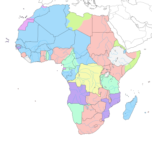
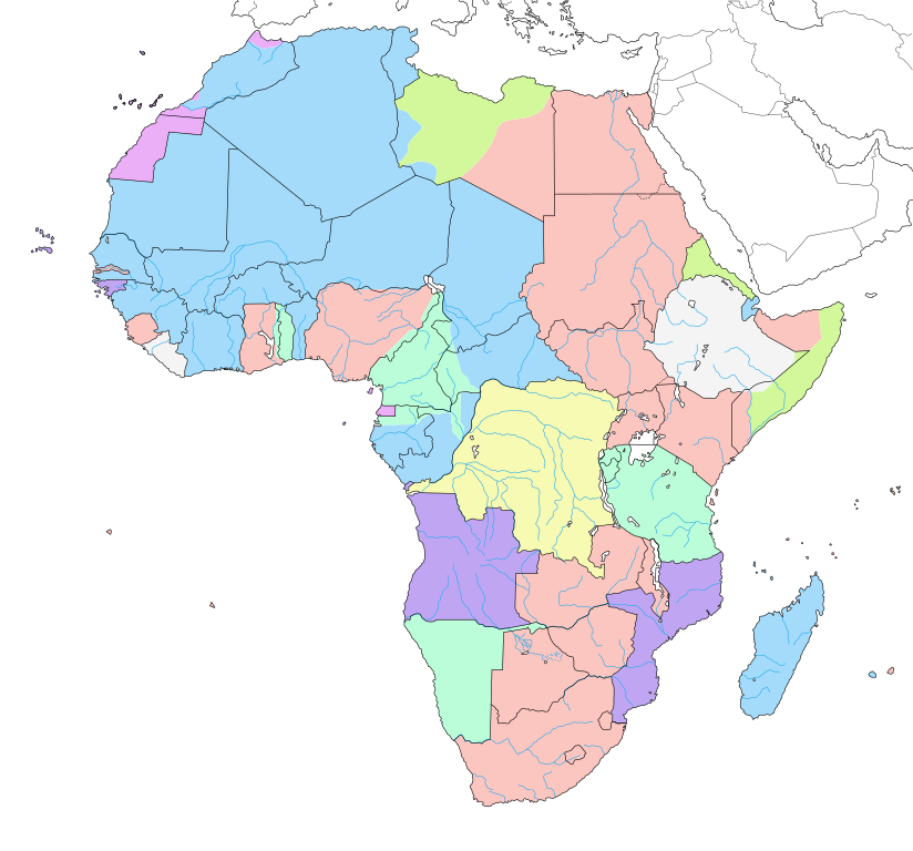
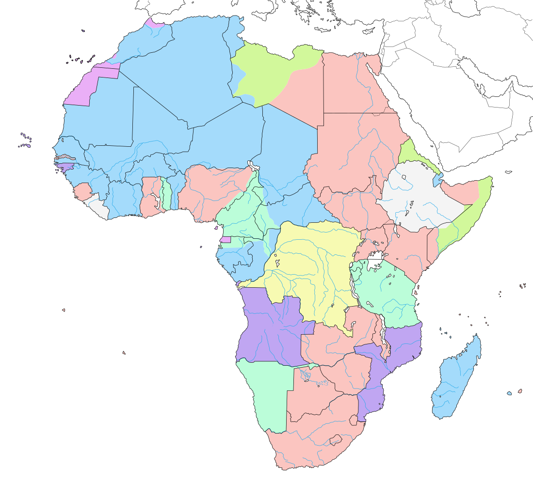
English: Map of colonial Africa as in 1913, with modern borders.
Note: The limits of the areas of control may not be perfectly accurate due to the imprecision of the reference maps. Deutsch: Karte des kolonialen Afrikas von 1913 mit modernen Grenzen.
Notiz: Die Grenzen der Kontrollbereiche sind aufgrund der Ungenauigkeit der Referenzkarten möglicherweise nicht ganz genau. Italiano: Mappa dell'Africa coloniale come nel 1913, con confini moderni.
Nota: I limiti delle aree di controllo potrebbero non essere perfettamente precisi a causa dell'imprecisione delle mappe di riferimento. Español: Mapa del África colonial como en 1913, con fronteras modernas.
Nota: Los límites de las áreas de control pueden no ser perfectamente precisos debido a la imprecisión de los mapas de referencia. Français : Carte de l'Afrique coloniale en 1913, avec frontières modernes. Note : Les limites des zones de contrôle peuvent ne pas être tout à fait exactes en raison de l'imprécision des cartes de référence utilisées. |
||
| Data | 2007ko ekaina, updated/corrected 2011-07 | ||
| Jatorria |
Norberak egina (Original text: Own work ;)
|
||
| Egilea | Eric Gaba (Sting - fr:Sting) | ||
| Lizentzia (Fitxategi hau berrerabiltzen) |
|
||
| Beste bertsioak |
[]
|
||
| SVG genesis |


.svg)

_ast.svg)


-es.svg)
_mapa.png)

_eu.svg)


.svg)

.jpg)


-sr.png)


.svg)


.svg)

Lizentzia
Eric Gaba, lan honen egileak, argitaratu du edo argitaratzen du ondorengo lizentzia hauen pean:

|
Baimena duzu dokumentu hau kopiatu, banatu edo/eta aldatzeko GNU Free Documentation License baldintzapean, Free Software Foundationek argitaratutako 1.2 edo ondorengo bertsioan; sekzio aldaezinik gabe, azaleko testurik gabe, eta atzeko azaleko testurik gabe. Lizentziaren kopia dago GNU Free Documentation License izenburudun atalean. |
| Fitxategi hau Creative Commons Attribution-Share Alike 3.0 Unported lizentziapean dago. | ||
| Aitortu: Eric Gaba – Wikimedia Commons user: Sting | ||
| ||
| This licensing tag was added to this file as part of the GFDL licensing update. |
This file is licensed under the Creative Commons Attribution-Share Alike 2.5 Generic license.
Aitortu: Eric Gaba – Wikimedia Commons user: Sting
- Askea zara:
- partekatzeko – lana kopiatzeko, banatzeko eta bidaltzeko
- birnahasteko – lana moldatzeko
- Ondorengo baldintzen pean:
- eskuduntza – Egiletza behar bezala aitortu behar duzu, lizentzia ikusteko esteka gehitu, eta ea aldaketak egin diren aipatu. Era egokian egin behar duzu hori guztia, baina inola ere ez egileak zure lana edo zure erabilera babesten duela irudikatuz.
- berdin partekatu – Lan honetan oinarrituta edo aldatuta berria eraikitzen baduzu, emaitza lana hau bezalako lizentzia batekin argitaratu behar duzu.
Nahiago duzun lizentzia erabil dezakezu.
Fitxategiaren historia
Data/orduan klik egin fitxategiak orduan zuen itxura ikusteko.
| Data/Ordua | Iruditxoa | Neurriak | Erabiltzailea | Iruzkina | |
|---|---|---|---|---|---|
| oraingoa | 16:29, 24 apirila 2019 | | 1.390 × 1.295 (660 KB) | Sting | Added surrounding landmasses ; waterbodies in white ; colour adjustment |
| 15:29, 5 uztaila 2018 |  | 1.390 × 1.295 (586 KB) | M3tainfo | Black borders with stroke width and removed local file refs | |
| 02:36, 3 martxoa 2014 |  | 1.390 × 1.295 (587 KB) | Sting | Reverted to version as of 13:06, 19 December 2013 | |
| 18:07, 2 martxoa 2014 |  | 1.390 × 1.295 (590 KB) | Knyaz-1988 | New version | |
| 18:05, 2 martxoa 2014 |  | 1.390 × 1.295 (587 KB) | Knyaz-1988 | New version | |
| 18:02, 2 martxoa 2014 |  | 1.390 × 1.295 (587 KB) | Knyaz-1988 | New version | |
| 15:06, 19 abendua 2013 |  | 1.390 × 1.295 (587 KB) | Sting | Correction : Fernando Pó/Bioko under Spanish domination | |
| 23:27, 14 uztaila 2011 |  | 1.390 × 1.295 (587 KB) | Sting | Sudan/South Sudan 2011-07 border update ; correction on the area of Cape Juby | |
| 09:23, 7 ekaina 2007 |  | 1.390 × 1.295 (642 KB) | Sting | Colour correction | |
| 08:52, 7 ekaina 2007 |  | 1.390 × 1.295 (642 KB) | Sting | Background |
Irudira dakarten loturak
Hurrengo orrialdeek dute fitxategi honetarako lotura:
Fitxategiaren erabilera orokorra
Hurrengo beste wikiek fitxategi hau darabilte:
- af.wikipedia.org proiektuan duen erabilera
- als.wikipedia.org proiektuan duen erabilera
- an.wikipedia.org proiektuan duen erabilera
- ar.wikipedia.org proiektuan duen erabilera
- ast.wikipedia.org proiektuan duen erabilera
- av.wikipedia.org proiektuan duen erabilera
- az.wikipedia.org proiektuan duen erabilera
- ba.wikipedia.org proiektuan duen erabilera
- bg.wikipedia.org proiektuan duen erabilera
- br.wikipedia.org proiektuan duen erabilera
- ca.wikipedia.org proiektuan duen erabilera
- ca.wikibooks.org proiektuan duen erabilera
- cs.wikipedia.org proiektuan duen erabilera
- da.wikipedia.org proiektuan duen erabilera
- de.wikipedia.org proiektuan duen erabilera
- diq.wikipedia.org proiektuan duen erabilera
- el.wikipedia.org proiektuan duen erabilera
- en.wikipedia.org proiektuan duen erabilera
Ikus fitxategi honen erabilpen global gehiago.