
Fitxategi:Interstate 74 map.png

Aurreikuspen honen neurria: 800 × 450 pixel. Bestelako bereizmenak: 320 × 180 pixel | 640 × 360 pixel | 1.024 × 575 pixel | 1.280 × 719 pixel | 2.205 × 1.239 pixel.
Bereizmen handikoa ((2.205 × 1.239 pixel, fitxategiaren tamaina: 94 KB, MIME mota: image/png))
Fitxategi hau Wikimedia Commonsekoa da. Hango deskribapen orriko informazioa behean duzu. |
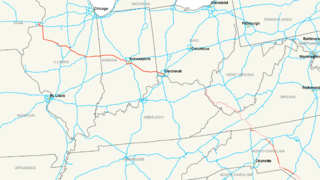
| Deskribapena | Map of Interstate 74 |
| Data | |
| Jatorria | Norberak egina |
| Egilea | Nick Nolte |
| Lizentzia (Fitxategi hau berrerabiltzen) |
Own work, all rights released (Public domain) |
Nik, lan honen egileak, argitaratzen dut ondorengo lizentzia pean:
| This file is made available under the Creative Commons CC0 1.0 Universal Public Domain Dedication. | |
| The person who associated a work with this deed has dedicated the work to the public domain by waiving all of their rights to the work worldwide under copyright law, including all related and neighboring rights, to the extent allowed by law. You can copy, modify, distribute and perform the work, even for commercial purposes, all without asking permission.
|
Fitxategiaren historia
Data/orduan klik egin fitxategiak orduan zuen itxura ikusteko.
| Data/Ordua | Iruditxoa | Neurriak | Erabiltzailea | Iruzkina | |
|---|---|---|---|---|---|
| oraingoa | 19:14, 24 ekaina 2017 | | 2.205 × 1.239 (94 KB) | Roadsguy | Updated to include current progress between Ellerbe and Winston-Salem, as well as more accurate routing of the proposed section along US 52 and the future Winston-Salem Northern Beltway. |
| 07:45, 11 abendua 2008 |  | 2.205 × 1.239 (155 KB) | MPD01605~commonswiki | Updated to include new sections of I-74 in North Carolina, also added pink shading for future route except in Ohio, as I could not find anything to solifify that route. | |
| 07:15, 16 uztaila 2006 |  | 2.205 × 1.239 (159 KB) | Stratosphere | {{Information| |Description=Map of Interstate 74 |Source=Own Work |Date=July 15, 2006 |Author=Nick Nolte |Permission=Own work, all rights released (Public domain) |other_versions= }} {{PD-self}} Category:U.S. Interstate Maps[ |
Irudira dakarten loturak
Hurrengo orrialdeek dute fitxategi honetarako lotura:
Fitxategiaren erabilera orokorra
Hurrengo beste wikiek fitxategi hau darabilte:
- de.wikipedia.org proiektuan duen erabilera
- fa.wikipedia.org proiektuan duen erabilera
- fr.wikipedia.org proiektuan duen erabilera
- ko.wikipedia.org proiektuan duen erabilera
- lmo.wikipedia.org proiektuan duen erabilera
- nl.wikipedia.org proiektuan duen erabilera
- pt.wikipedia.org proiektuan duen erabilera
- ru.wikipedia.org proiektuan duen erabilera
- sv.wikipedia.org proiektuan duen erabilera
- vi.wikipedia.org proiektuan duen erabilera
- www.wikidata.org proiektuan duen erabilera
- zh.wikipedia.org proiektuan duen erabilera