
Fitxategi:Ankara districts.png
Ez dago bereizmen handiagorik.
Ankara_districts.png ((733 × 600 pixel, fitxategiaren tamaina: 166 KB, MIME mota: image/png))
Fitxategi hau Wikimedia Commonsekoa da. Hango deskribapen orriko informazioa behean duzu. |
Laburpena
| Deskribapena |
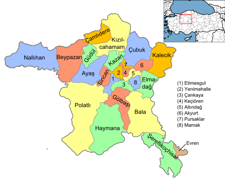
English: Map of the districts of Ankara province of Turkey. Created by Rarelibra 16:37, 1 December 2006 (UTC) for public domain use, using MapInfo Professional v8.5 and various mapping resources. Edited by One Homo Sapiens Corrected text where İ,Ş,ı,ğ,or ş occurs in name. Source: [statoids-com]. Increased font size and enhanced color differences among adjacent districts. |
| Data | 2006ko abenduaren 1ea (Jatorrizko igoera-data) |
| Jatorria | No machine-readable source provided. Own work assumed (based on copyright claims). |
| Egilea | No machine-readable author provided. Rarelibra assumed (based on copyright claims). |
Lizentzia
| Nik, lan honen egile eskubideen jabeak, lan hau domeinu publikoan jartzen dut. Mundu osoan du eragina honek. Estatu batzuetan beharbada hori ez da legez posible izango. Halakoetan: Edonori ematen diot lan hau edozertarako erabiltzeko eskubidea, inolako baldintzarik gabe, legeak nahitaez ezarritako baldintzak izan ezik. |
Fitxategiaren historia
Data/orduan klik egin fitxategiak orduan zuen itxura ikusteko.
| Data/Ordua | Iruditxoa | Neurriak | Erabiltzailea | Iruzkina | |
|---|---|---|---|---|---|
| oraingoa | 17:08, 15 iraila 2015 | | 733 × 600 (166 KB) | AylakBiri | Yeni sınırlar. |
| 20:59, 1 ekaina 2014 |  | 1.056 × 864 (198 KB) | Joseph48 | - "Pursaklar" added. - Borders changed using File:Ankara location Pursaklar.svg | |
| 20:00, 22 urria 2011 |  | 1.056 × 816 (48 KB) | Karedefter | small things | |
| 21:40, 21 azaroa 2010 |  | 1.056 × 816 (48 KB) | Joseph48 | Şultan Koçhisar > Şerefli Koçhisar | |
| 22:37, 28 abendua 2008 |  | 1.056 × 816 (41 KB) | One Homo Sapiens | Corrected text where İ,Ş,ı,ğ,or ş occurs in name. Source: [statoids-com]. Increased font size and enhanced color differences among adjacent districts. | |
| 18:37, 1 abendua 2006 |  | 1.056 × 816 (40 KB) | Rarelibra | Map of the districts of Ankara province of Turkey. Created by ~~~~ for public domain use, using MapInfo Professional v8.5 and various mapping resources. |
Irudira dakarten loturak
Hurrengo orrialdeek dute fitxategi honetarako lotura:
Fitxategiaren erabilera orokorra
Hurrengo beste wikiek fitxategi hau darabilte:
- ar.wikipedia.org proiektuan duen erabilera
- azb.wikipedia.org proiektuan duen erabilera
- az.wikipedia.org proiektuan duen erabilera
- ba.wikipedia.org proiektuan duen erabilera
- br.wikipedia.org proiektuan duen erabilera
- ca.wikipedia.org proiektuan duen erabilera
- ceb.wikipedia.org proiektuan duen erabilera
- ckb.wikipedia.org proiektuan duen erabilera
- crh.wikipedia.org proiektuan duen erabilera
- cs.wikipedia.org proiektuan duen erabilera
- cy.wikipedia.org proiektuan duen erabilera
- de.wikipedia.org proiektuan duen erabilera
- Şereflikoçhisar
- Ankara (Provinz)
- Kızılcahamam
- Etimesgut
- Gölbaşı (Ankara)
- Haymana
- Evren (Ankara)
- Polatlı
- Sincan (Ankara)
- Vorlage:Navigationsleiste Landkreise der Provinz Ankara
- Çankaya
- Keçiören
- Mamak
- Kalecik
- Beypazarı
- Ayaş (Ankara)
- Yenimahalle
- Altındağ
- Balâ
- Elmadağ (Ankara)
- Nallıhan
- Pursaklar
- Çamlıdere (Ankara)
Ikus fitxategi honen erabilpen global gehiago.