
Fitxategi:Chechnya03.png
Aurreikuspen honen neurria: 524 × 599 pixel. Bestelako bereizmenak: 210 × 240 pixel | 420 × 480 pixel | 677 × 774 pixel.
Bereizmen handikoa ((677 × 774 pixel, fitxategiaren tamaina: 38 KB, MIME mota: image/png))
Fitxategi hau Wikimedia Commonsekoa da. Hango deskribapen orriko informazioa behean duzu. |
Laburpena
| Deskribapena |
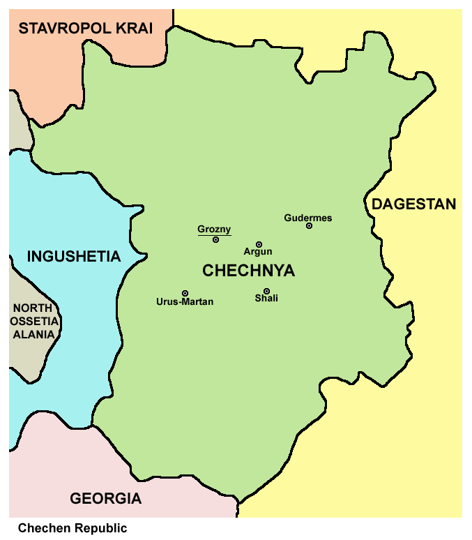
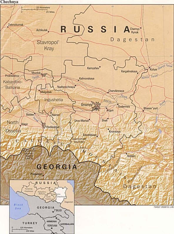
English: map of Chechnya, labelled in English
Esperanto: skema mapo de Ĉeĉenio, priskriboj en la angla |
| Data | |
| Jatorria | Norberak egina |
| Egilea | PANONIAN |
| Beste bertsioak |
Chechnya03 af.png (Afrikaans), Ĉeĉenio.png (Esperanto), Ĉeĉenio sen nomoj.png (blank) Converted to SVG: Ĉeĉenio.svg (Esperanto), Ĉeĉenio DE.svg (German), Ĉeĉenio LT.svg (Lithuanian) |
Lizentzia

|
This map has been uploaded by Electionworld from en.wikipedia.org to enable the |
Map made by PANONIAN
| This work has been released into the public domain by its author, PANONIAN. This applies worldwide. Estatu batzuetan beharbada hori ez da legez posible izango. Halakoetan: |
References
- http://www.mapzones.com/citymap/russia/chechnya/chechnya.jpg
- http://www.worldatlas.com/webimage/countrys/europe/chechsml.gif
- http://mapas.owje.com/img/Mapa-de-Relieve-Sombreado-de-Chechenia-Rusia-4739.jpg
- http://www.infoplease.com/images/mchechnya.gif
- http://boes.org/child/russia/images/mapchechnya4.jpg
- http://www.robinsonlibrary.com/history/eastern/russia/russia/graphics/chechnya-map.jpg archive copy at the Wayback Machine
- http://www.bestcountryreports.com/media/D_Images/Chechn_Pol.jpg
- http://rdaward.org/map/6p.jpg
- http://galgai.com/misc/ChechenIngushMap.jpg
- http://t1.ftcdn.net/jpg/00/37/98/16/400_F_37981654_ihQ94XNq7FqYvyOyjZtaqTLTQ8SDLr1u.jpg
- http://img.timeinc.net/time/photoessays/grozny/images/map.gif
- http://lh4.ggpht.com/-V5LOo3pqLNc/S8Uwzwc3vqI/AAAAAAAAAWw/v4_PKVb19o4/chechnya4.gif.jpg
Fitxategiaren historia
Data/orduan klik egin fitxategiak orduan zuen itxura ikusteko.
| Data/Ordua | Iruditxoa | Neurriak | Erabiltzailea | Iruzkina | |
|---|---|---|---|---|---|
| oraingoa | 17:39, 1 otsaila 2020 | | 677 × 774 (38 KB) | PANONIAN | Reverted to version as of 16:36, 16 April 2012 (UTC) - please upload your map version under different file name |
| 00:58, 17 urtarrila 2020 |  | 8.770 × 8.963 (1,51 MB) | Takhirgeran Umar | об | |
| 00:49, 17 urtarrila 2020 |  | 8.231 × 8.437 (1,46 MB) | Takhirgeran Umar | Between the republics have established borders. Until 2018, there were no borders. | |
| 18:36, 16 apirila 2012 |  | 677 × 774 (38 KB) | PANONIAN | improved version | |
| 18:10, 29 abendua 2006 |  | 530 × 601 (18 KB) | Electionworld | {{ew|en|PANONIAN}} Map made by PANONIAN {{PD-user|PANONIAN}} Category:Maps of the Russian republics |
Irudira dakarten loturak
Ez dago fitxategi hau darabilen orririk.
Fitxategiaren erabilera orokorra
Hurrengo beste wikiek fitxategi hau darabilte:
- ru.wikinews.org proiektuan duen erabilera