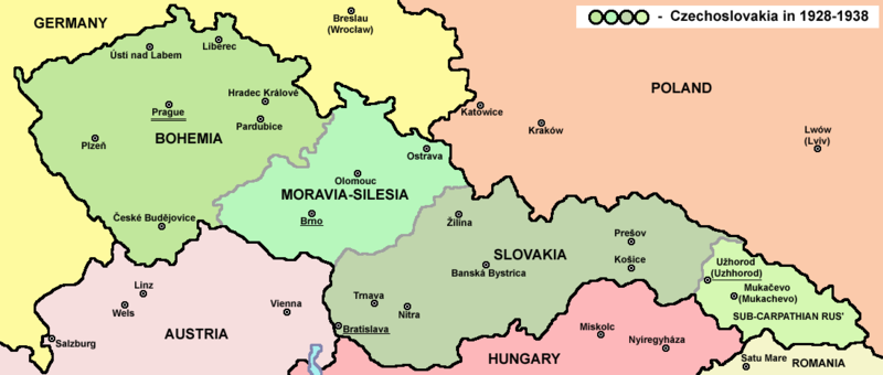
Fitxategi:Czechoslovakia01.png

Aurreikuspen honen neurria: 800 × 340 pixel. Bestelako bereizmenak: 320 × 136 pixel | 1.100 × 468 pixel.
Bereizmen handikoa ((1.100 × 468 pixel, fitxategiaren tamaina: 63 KB, MIME mota: image/png))
Fitxategiaren historia
Data/orduan klik egin fitxategiak orduan zuen itxura ikusteko.
| Data/Ordua | Iruditxoa | Neurriak | Erabiltzailea | Iruzkina | |
|---|---|---|---|---|---|
| oraingoa | 16:48, 12 uztaila 2022 |  | 1.100 × 468 (63 KB) | Sebastian Wallroth | cropped |
| 12:54, 19 maiatza 2011 |  | 1.128 × 513 (63 KB) | PANONIAN | minor change, marked provincial capitals | |
| 11:53, 17 maiatza 2011 |  | 1.128 × 513 (62 KB) | PANONIAN | Reverted to version as of 10:38, 24 April 2011 - because this is map of Czechoslovakia and it was capital of Czechoslovakia | |
| 07:07, 17 maiatza 2011 |  | 1.128 × 513 (55 KB) | Millenium187 | Why was Prague underlined and Vienna, Brno, Bratislava and other capital cities were not? -- corrected | |
| 12:38, 24 apirila 2011 |  | 1.128 × 513 (62 KB) | PANONIAN | few corrections | |
| 13:31, 23 apirila 2011 |  | 1.128 × 509 (61 KB) | PANONIAN | improved version | |
| 22:58, 20 abendua 2008 |  | 1.100 × 497 (78 KB) | Kirk979 | {{Information |Description= |Source= |Date= |Author= |Permission= |other_versions= }} | |
| 18:11, 28 abendua 2006 |  | 1.100 × 497 (90 KB) | Electionworld | {{ew|en|PANONIAN}} Map of {{link|Czechoslovakia}} (self made) Note: The provinces shown on the map were introduced by Act No. 125/1927 Zb. and became effective in 1928. {{PD-self}} Category:Maps of Czechoslovakia Category:Maps of Czech history |
Irudira dakarten loturak
Hurrengo orrialdeek dute fitxategi honetarako lotura:
Fitxategiaren erabilera orokorra
Hurrengo beste wikiek fitxategi hau darabilte:
- af.wikipedia.org proiektuan duen erabilera
- als.wikipedia.org proiektuan duen erabilera
- ang.wikipedia.org proiektuan duen erabilera
- an.wikipedia.org proiektuan duen erabilera
- ar.wikipedia.org proiektuan duen erabilera
- arz.wikipedia.org proiektuan duen erabilera
- azb.wikipedia.org proiektuan duen erabilera
- az.wikipedia.org proiektuan duen erabilera
- ba.wikipedia.org proiektuan duen erabilera
- bcl.wikipedia.org proiektuan duen erabilera
- be-tarask.wikipedia.org proiektuan duen erabilera
- be.wikipedia.org proiektuan duen erabilera
- bg.wikipedia.org proiektuan duen erabilera
- bn.wikipedia.org proiektuan duen erabilera
- br.wikipedia.org proiektuan duen erabilera
- ca.wikipedia.org proiektuan duen erabilera
- cs.wikipedia.org proiektuan duen erabilera
- cv.wikipedia.org proiektuan duen erabilera
- cy.wikipedia.org proiektuan duen erabilera
- de.wikipedia.org proiektuan duen erabilera
- diq.wikipedia.org proiektuan duen erabilera
- dsb.wikipedia.org proiektuan duen erabilera
- el.wikipedia.org proiektuan duen erabilera
- en.wikipedia.org proiektuan duen erabilera
Ikus fitxategi honen erabilpen global gehiago.


