
Fitxategi:Franklingulfstream.jpg
Aurreikuspen honen neurria: 736 × 599 pixel. Bestelako bereizmenak: 295 × 240 pixel | 590 × 480 pixel | 943 × 768 pixel | 1.258 × 1.024 pixel | 2.516 × 2.048 pixel | 3.089 × 2.515 pixel.
Bereizmen handikoa ((3.089 × 2.515 pixel, fitxategiaren tamaina: 1,2 MB, MIME mota: image/jpeg))
Fitxategi hau Wikimedia Commonsekoa da. Hango deskribapen orriko informazioa behean duzu. |
| Deskribapena |
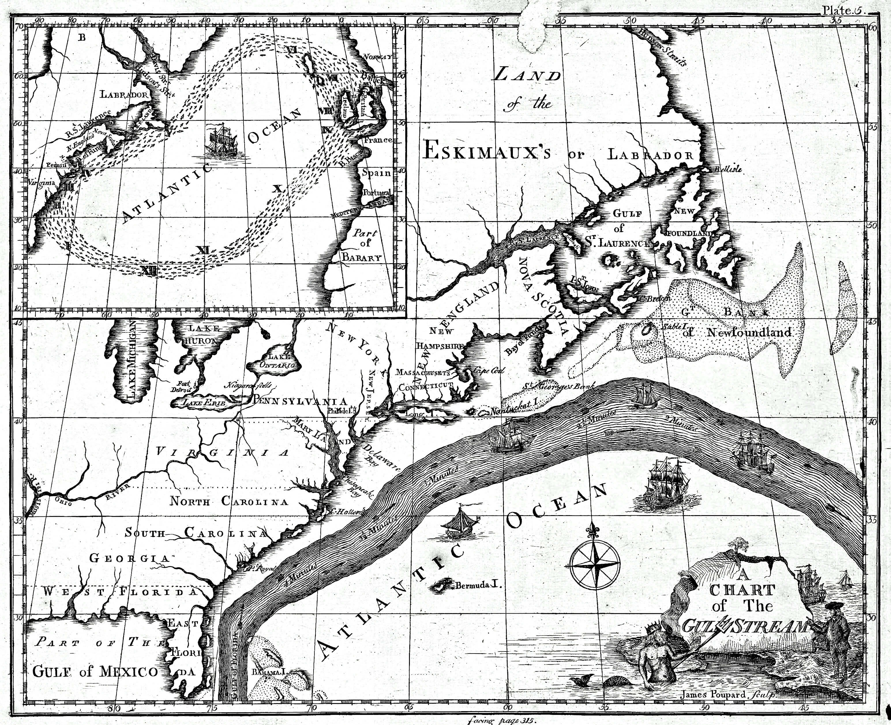
English: Earliest known map of the Gulf Stream |
| Data | |
| Jatorria |
https://www.loc.gov/resource/g9112g.ct000136/ (2018-03-20)
|
| Egilea | Library of Congress/Benjamin Franklin |
| Beste bertsioak |
Cropped version uploaded in September 2016: |
Lizentzia
This image is in the public domain because it contains materials that originally came from the U.S. National Oceanic and Atmospheric Administration, taken or made as part of an employee's official duties.
|
Jatorrizko igoera erregistroa
The original description page was here. All following user names refer to en.wikipedia.
- 2008-09-21 12:47 Thegreatdr 540×433× (79994 bytes) {{Information |Description=Earliest known map of the Gulf Stream |Source=http://oceanexplorer.noaa.gov/library/readings/hires/gulf_stream_map.jpg |Date=2008-09-21 |Author=Library of Congress/Benjamin Franklin |Permission= |other_versions= }}
Fitxategiaren historia
Data/orduan klik egin fitxategiak orduan zuen itxura ikusteko.
| Data/Ordua | Iruditxoa | Neurriak | Erabiltzailea | Iruzkina | |
|---|---|---|---|---|---|
| oraingoa | 19:11, 25 apirila 2021 | | 3.089 × 2.515 (1,2 MB) | RCraig09 | Version 4: reduced file size at tinyjpg.com |
| 22:32, 20 martxoa 2018 |  | 3.089 × 2.515 (2,45 MB) | RCraig09 | Updated version from Library of Congress in response to note on talk page about watermark asserted to be present in earlier uploads. Source (2019-03-20): https://www.loc.gov/resource/g9112g.ct000136/ | |
| 22:39, 26 martxoa 2012 |  | 5.868 × 4.761 (5,07 MB) | ServiceAT | Replaced low resolution image by higher resolution scan of same original. | |
| 12:37, 7 uztaila 2009 |  | 540 × 433 (78 KB) | Nk | {{Information |Description={{en|Earliest known map of the Gulf Stream}} |Source=Transferred from [http://en.wikipedia.org en.wikipedia]<br/> (Original text : ''http://oceanexplorer.noaa.gov/library/readings/hires/gulf_stream_map.jpg'') |Date={{Date|2008|0 |
Irudira dakarten loturak
Hurrengo orrialdeek dute fitxategi honetarako lotura:
Fitxategiaren erabilera orokorra
Hurrengo beste wikiek fitxategi hau darabilte:
- ast.wikipedia.org proiektuan duen erabilera
- ba.wikipedia.org proiektuan duen erabilera
- bg.wikipedia.org proiektuan duen erabilera
- bs.wikipedia.org proiektuan duen erabilera
- ca.wikipedia.org proiektuan duen erabilera
- en.wikipedia.org proiektuan duen erabilera
- es.wikipedia.org proiektuan duen erabilera
- fi.wikipedia.org proiektuan duen erabilera
- fr.wikipedia.org proiektuan duen erabilera
- ha.wikipedia.org proiektuan duen erabilera
- it.wikipedia.org proiektuan duen erabilera
- kn.wikipedia.org proiektuan duen erabilera
- mk.wikipedia.org proiektuan duen erabilera
- ms.wikipedia.org proiektuan duen erabilera
- nn.wikipedia.org proiektuan duen erabilera
- no.wikipedia.org proiektuan duen erabilera
- ru.wikipedia.org proiektuan duen erabilera
- si.wikipedia.org proiektuan duen erabilera
- sr.wikipedia.org proiektuan duen erabilera
- tr.wikipedia.org proiektuan duen erabilera
- uk.wikipedia.org proiektuan duen erabilera
- vi.wikipedia.org proiektuan duen erabilera
- zh.wikipedia.org proiektuan duen erabilera