
Fitxategi:Hautes Pyrenees topographic map-fr.svg

SVG fitxategi honen PNG aurreikuspenaren tamaina: 486 × 600 pixel. Bestelako bereizmenak: 194 × 240 pixel | 389 × 480 pixel | 622 × 768 pixel | 830 × 1.024 pixel | 1.659 × 2.048 pixel | 1.132 × 1.397 pixel.
Bereizmen handikoa (SVG fitxategia, nominaldi 1.132 × 1.397 pixel, fitxategiaren tamaina: 605 KB)
Fitxategi hau Wikimedia Commonsekoa da. Hango deskribapen orriko informazioa behean duzu. |
Laburpena
| Deskribapena |
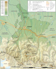
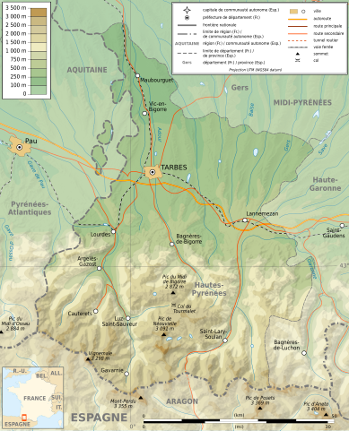
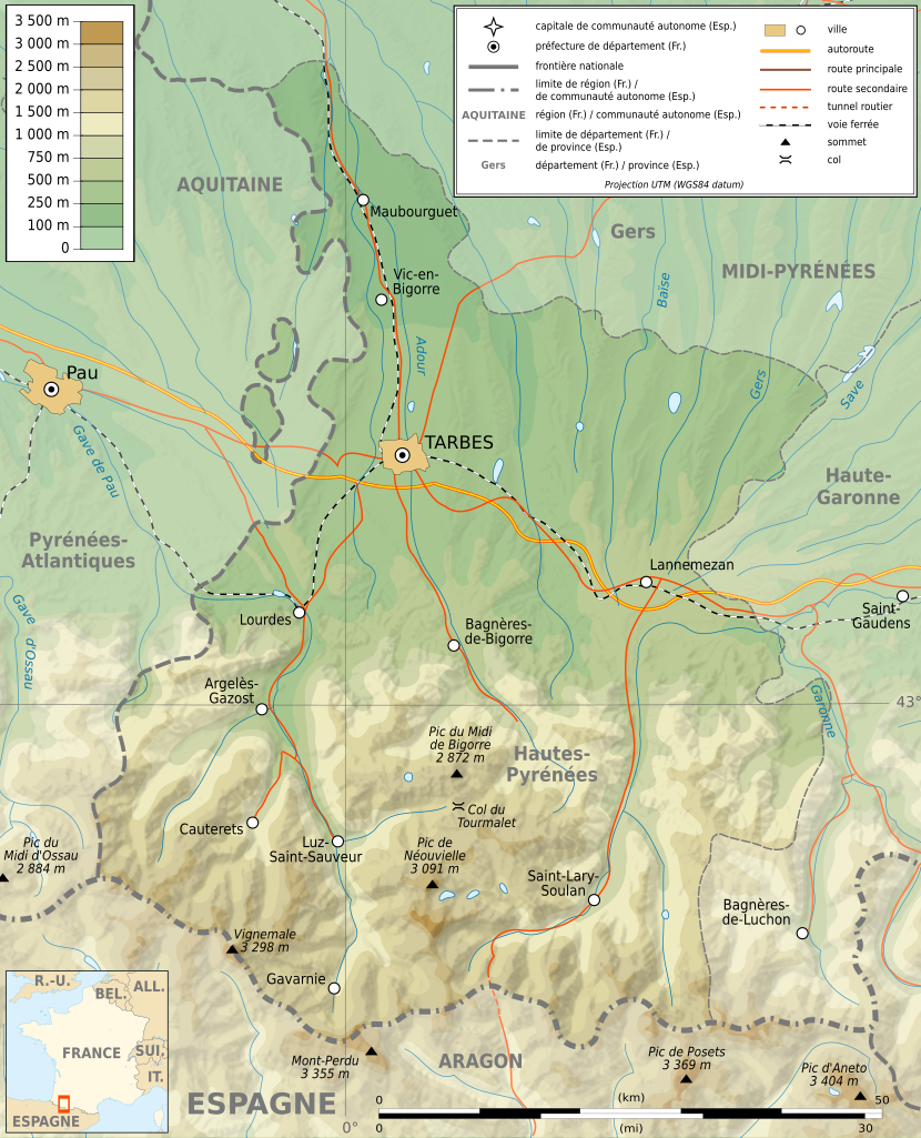
English: Topographic map in French of the department of the Hautes-Pyrénées Français : Carte topographique en français du département des Hautes-Pyrénées |
| Data | |
| Jatorria |
English: Extract from Image:Pyrenees topographic map-fr.svg and Image:Pyrenees map shaded relief-fr.svg by Sting.
Français : Extrait de Image:Pyrenees topographic map-fr.svg et Image:Pyrenees map shaded relief-fr.svg par Sting.
|
| Egilea | Sémhur ; author of the original map : Eric Gaba (Sting - fr:Sting) |
| Lizentzia (Fitxategi hau berrerabiltzen) |
GFDL / Attribution and Share-Alike required |
| Beste bertsioak |
|

| Kameraren kokapena | | Irudi hau eta gehiago beraien kokapenekin hurrengo lekuetan: OpenStreetMap |
|---|

|
SVG fitxategi honek Inkscape edo Adobe Illustrator bezalako SVG editore bat erabiliz erraz itzul daitekeen barneratutako testua du. Argibide gehiago. Nahi izanez gero, fitxategia jaitsi eta testu editore bat erabiliz ere itzul dezakezu. |
Lizentzia
Nik, lan honen egileak, argitaratzen dut ondorengo lizentzia hauen pean:

|
Baimena duzu dokumentu hau kopiatu, banatu edo/eta aldatzeko GNU Free Documentation License baldintzapean, Free Software Foundationek argitaratutako 1.2 edo ondorengo bertsioan; sekzio aldaezinik gabe, azaleko testurik gabe, eta atzeko azaleko testurik gabe. Lizentziaren kopia dago GNU Free Documentation License izenburudun atalean. |
This file is licensed under the Creative Commons Attribution-Share Alike 4.0 International, 3.0 Unported, 2.5 Generic, 2.0 Generic and 1.0 Generic license.
- Askea zara:
- partekatzeko – lana kopiatzeko, banatzeko eta bidaltzeko
- birnahasteko – lana moldatzeko
- Ondorengo baldintzen pean:
- eskuduntza – Egiletza behar bezala aitortu behar duzu, lizentzia ikusteko esteka gehitu, eta ea aldaketak egin diren aipatu. Era egokian egin behar duzu hori guztia, baina inola ere ez egileak zure lana edo zure erabilera babesten duela irudikatuz.
- berdin partekatu – Lan honetan oinarrituta edo aldatuta berria eraikitzen baduzu, emaitza lana hau bezalako lizentzia batekin argitaratu behar duzu.
Nahiago duzun lizentzia erabil dezakezu.
Fitxategiaren historia
Data/orduan klik egin fitxategiak orduan zuen itxura ikusteko.
| Data/Ordua | Iruditxoa | Neurriak | Erabiltzailea | Iruzkina | |
|---|---|---|---|---|---|
| oraingoa | 08:55, 16 otsaila 2009 | | 1.132 × 1.397 (605 KB) | Hektor | |
| 18:11, 16 uztaila 2008 |  | 1.132 × 1.397 (573 KB) | Sémhur | == Summary == {{Location dec|43|0.15|type:adm2nd_region:FR-MP_scale:1000000}} <br/> {{Information |Description={{en|Topographic map in French of the department of the Hautes-Pyrénées}}{{fr|Carte topographique en français du d� |
Irudira dakarten loturak
Hurrengo orrialdeek dute fitxategi honetarako lotura:
Fitxategiaren erabilera orokorra
Hurrengo beste wikiek fitxategi hau darabilte:
- br.wikipedia.org proiektuan duen erabilera
- ca.wikipedia.org proiektuan duen erabilera
- de.wikipedia.org proiektuan duen erabilera
- el.wikipedia.org proiektuan duen erabilera
- en.wikipedia.org proiektuan duen erabilera
- fr.wikipedia.org proiektuan duen erabilera
- hu.wikipedia.org proiektuan duen erabilera
- ja.wikipedia.org proiektuan duen erabilera
- simple.wikipedia.org proiektuan duen erabilera
- sq.wikipedia.org proiektuan duen erabilera