
Fitxategi:India-states-numbered.svg

Bereizmen handikoa (SVG fitxategia, nominaldi 1.594 × 1.868 pixel, fitxategiaren tamaina: 306 KB)
Fitxategi hau Wikimedia Commonsekoa da. Hango deskribapen orriko informazioa behean duzu. |
Laburpena
| Deskribapena |
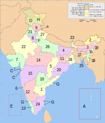
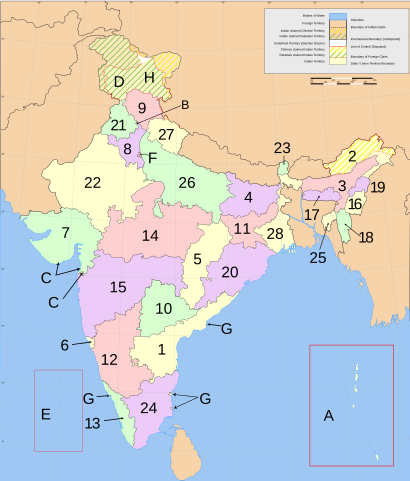
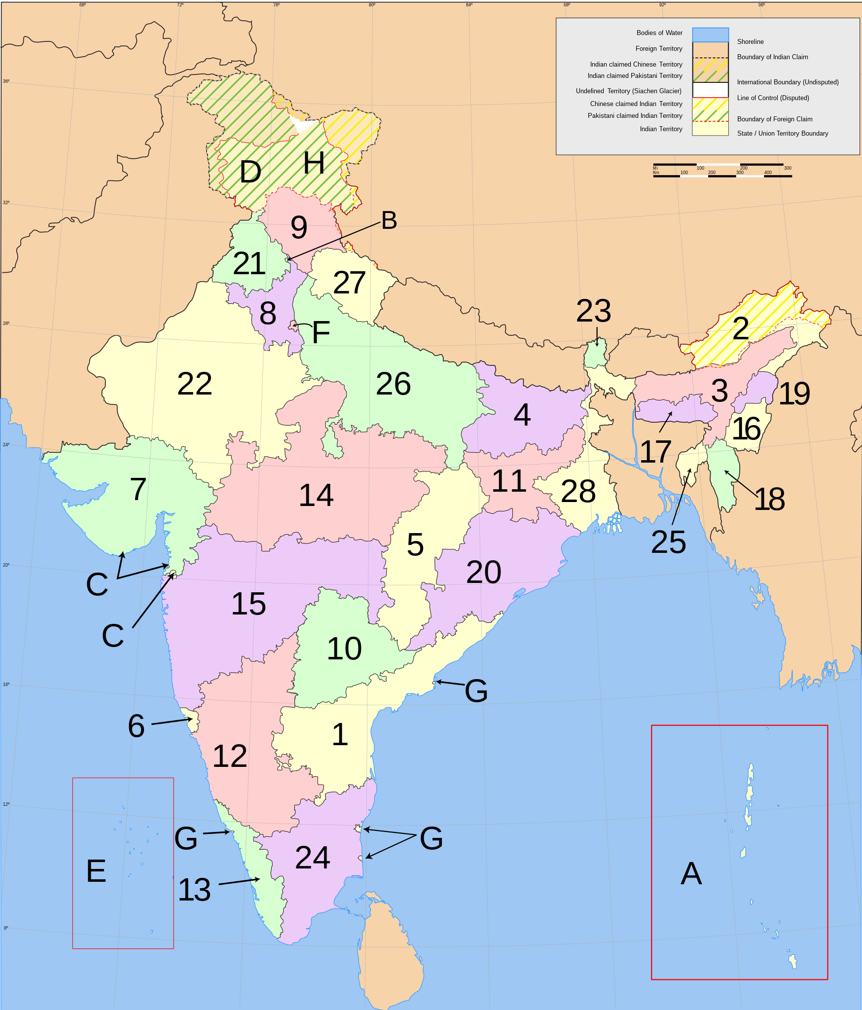
English: States of India, numbered.
Norsk nynorsk: Indiske statar og territorium |
| Data | See file history below. |
| Jatorria | Based on Planemad's w:Image:India map en.svg |
| Egilea | See file history below. |
English: Main administrative divisions of india
India consists of 28 states and eight union territories. All states, and the three union territories of Jammu and Kashmir, Puducherry and Delhi, have elected legislatures and governments patterned on the Westminster model. The other five union territories are directly ruled by the Central government through appointed administrators. In 1956, under the States Reorganisation Act, states were formed on a linguistic basis.[1] Since then, this structure has remained largely unchanged.
Each state or union territory is further divided into administrative districts.[2] The districts in turn are further divided into:
- in rural areas: (named tehsils / taluks / mandals / subdivisions / circles / communes depending of the state or territory), local councils (gram panchayats), and eventually into villages and wards (gram sabhas), or
- in large urban areas: metropoles (comparable to subdistricts but with more autonomy), municipalities (or municipal corporations), and eventually into civic zones and civic wards.
For interstate cooperation and planning, the 28 states and 8 union territories are also grouped into 6 zones.
- States
- Andhra Pradesh
- Arunachal Pradesh
- Assam
- Bihar
- Chhattisgarh
- Goa
- Gujarat
- Haryana
- Himachal Pradesh
- Telangana
- Jharkhand
- Karnataka
- Kerala
- Madhya Pradesh
- Maharashtra
- Manipur
- Meghalaya
- Mizoram
- Nagaland
- Orissa
- Punjab
- Rajasthan
- Sikkim
- Tamil Nadu
- Tripura
- Uttar Pradesh
- Uttarakhand
- West Bengal
- Union territories
Esperanto: Subŝtatoj kaj teritorioj de Barato
- Subŝtatoj
- Andra-Pradeŝo
- Arunaĉal-Pradeŝo
- Asamo
- Biharo
- Ĉatisgaro
- Goao
- Guĝarato
- Harjano
- Himaĉal-Pradeŝo
- Ĝamuo kaj Kaŝmiro
- Ĝarkhando
- Karnatako
- Keralao
- Madhja-Pradeŝo
- Maharaŝtro
- Manipuro
- Meghalajo
- Mizoramo
- Nagalando
- Oriso
- Panĝabo
- Raĝastano
- Sikimo
- Tamilnado
- Tripuro
- Utar-Pradeŝo
- Utarakando
- Okcidenta Bengalio
- Telangano
- Uniaj teritorioj
Norsk nynorsk: Indiske statar og territorium
- Statas
- Andhra Pradesh
- Arunachal Pradesh
- Assam
- Bihar
- Chhattisgarh
- Goa
- Gujarat
- Haryana
- Himachal Pradesh
- Jammu og Kashmir
- Jharkhand
- Karnataka
- Kerala
- Madhya Pradesh
- Maharashtra
- Manipur
- Meghalaya
- Mizoram
- Nagaland
- Orissa
- Punjab|
- Rajasthan
- Sikkim
- Tamil Nadu
- Tripura
- Uttar Pradesh
- Uttarakhand
- Vest-Bengal
- Telangana
- Unionsterritorium
References
- ↑ States Reorganisation Act, 1956. Constitution of India. Commonwealth Legal Information Institute. Archived from the original on 2008-05-16. Retrieved on 31 October 2007.; See also: Political integration of India.
- ↑ Districts of India. Government of India. National Informatics Centre (NIC). Retrieved on 25 November 2007.
Lizentzia

|
Baimena duzu dokumentu hau kopiatu, banatu edo/eta aldatzeko GNU Free Documentation License baldintzapean, Free Software Foundationek argitaratutako 1.2 edo ondorengo bertsioan; sekzio aldaezinik gabe, azaleko testurik gabe, eta atzeko azaleko testurik gabe. Lizentziaren kopia dago GNU Free Documentation License izenburudun atalean. |
| Fitxategi hau Creative Commons Attribution-Share Alike 3.0 Unported lizentziapean dago. | ||
| ||
| This licensing tag was added to this file as part of the GFDL licensing update. |
- Askea zara:
- partekatzeko – lana kopiatzeko, banatzeko eta bidaltzeko
- birnahasteko – lana moldatzeko
- Ondorengo baldintzen pean:
- eskuduntza – Egiletza behar bezala aitortu behar duzu, lizentzia ikusteko esteka gehitu, eta ea aldaketak egin diren aipatu. Era egokian egin behar duzu hori guztia, baina inola ere ez egileak zure lana edo zure erabilera babesten duela irudikatuz.
Fitxategiaren historia
Data/orduan klik egin fitxategiak orduan zuen itxura ikusteko.
| Data/Ordua | Iruditxoa | Neurriak | Erabiltzailea | Iruzkina | |
|---|---|---|---|---|---|
| oraingoa | 20:08, 10 urtarrila 2021 | | 1.594 × 1.868 (306 KB) | Sbb1413 | Updated further. |
| 14:24, 25 urtarrila 2016 |  | 1.594 × 1.868 (309 KB) | Csyogi | Telangana State update | |
| 06:35, 3 abendua 2011 |  | 1.594 × 1.868 (297 KB) | Kmusser | Re-size Goa label | |
| 20:38, 24 azaroa 2011 |  | 1.594 × 1.868 (276 KB) | Fred the Oyster | Tidy up, use Arial font as more 'universal' | |
| 17:34, 5 urria 2011 |  | 1.594 × 1.868 (298 KB) | Citypeek | changed font from Sans to DejaVu Sans. | |
| 09:51, 5 martxoa 2007 |  | 1.594 × 1.868 (304 KB) | Nichalp | Swapping Pondicherry NCT | |
| 07:59, 4 martxoa 2007 |  | 1.594 × 1.868 (304 KB) | Nichalp | Correction in the numbering scheme according to MoS | |
| 17:58, 15 otsaila 2007 |  | 1.594 × 1.868 (304 KB) | Nichalp | Reverted to earlier revision | |
| 02:39, 12 otsaila 2007 |  | 1.594 × 1.868 (304 KB) | Abecedare | Reverted to earlier revision | |
| 08:07, 25 azaroa 2006 |  | 1.594 × 1.868 (304 KB) | Nichalp | Reverted to earlier revision |
Irudira dakarten loturak
Hurrengo orrialdeek dute fitxategi honetarako lotura:
Fitxategiaren erabilera orokorra
Hurrengo beste wikiek fitxategi hau darabilte:
- ang.wikipedia.org proiektuan duen erabilera
- an.wikipedia.org proiektuan duen erabilera
- ast.wikipedia.org proiektuan duen erabilera
- as.wikipedia.org proiektuan duen erabilera
- ban.wikipedia.org proiektuan duen erabilera
- be-tarask.wikipedia.org proiektuan duen erabilera
- be.wikipedia.org proiektuan duen erabilera
- bg.wikipedia.org proiektuan duen erabilera
- bh.wikipedia.org proiektuan duen erabilera
- blk.wikipedia.org proiektuan duen erabilera
- bn.wikipedia.org proiektuan duen erabilera
- bpy.wikipedia.org proiektuan duen erabilera
- br.wikipedia.org proiektuan duen erabilera
- bs.wikipedia.org proiektuan duen erabilera
- ca.wikipedia.org proiektuan duen erabilera
- da.wikipedia.org proiektuan duen erabilera
- diq.wikipedia.org proiektuan duen erabilera
- dv.wikipedia.org proiektuan duen erabilera
- el.wikipedia.org proiektuan duen erabilera
- en.wikipedia.org proiektuan duen erabilera
- File talk:India-locator-map-blank.svg
- User:Jonny-mt/Gallery of current first-level administrative country subdivisions maps
- Template talk:Christianity in India sidebar
- Talk:Serbia/Archive 4
- File:India-states.svg
- File:Indiastates.jpg
- Talk:India/Archive 28
- Wikipedia:Graphics Lab/Map workshop/Archive/Dec 2011
- Talk:China/Archive 15
- User:Gufranazmi
- User:Ibsind
- Wikipedia:Graphics Lab/Map workshop/Archive/Mar 2018
- en.wiktionary.org proiektuan duen erabilera
- es.wikipedia.org proiektuan duen erabilera
Ikus fitxategi honen erabilpen global gehiago.