
Fitxategi:India southwest summer monsoon onset map en.svg

Bereizmen handikoa (SVG fitxategia, nominaldi 1.639 × 1.852 pixel, fitxategiaren tamaina: 656 KB)
Fitxategi hau Wikimedia Commonsekoa da. Hango deskribapen orriko informazioa behean duzu. |
| Izenburua |
India climatic zone map english version |
|||||||||
| Deskripzio |
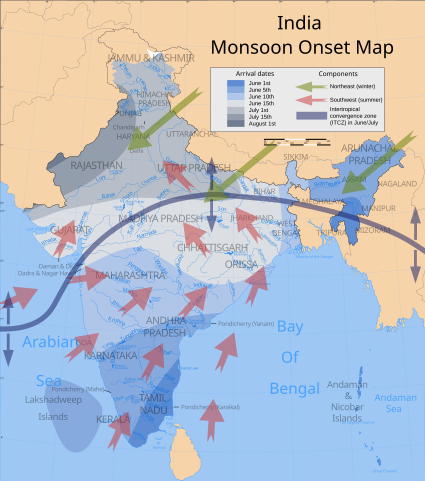
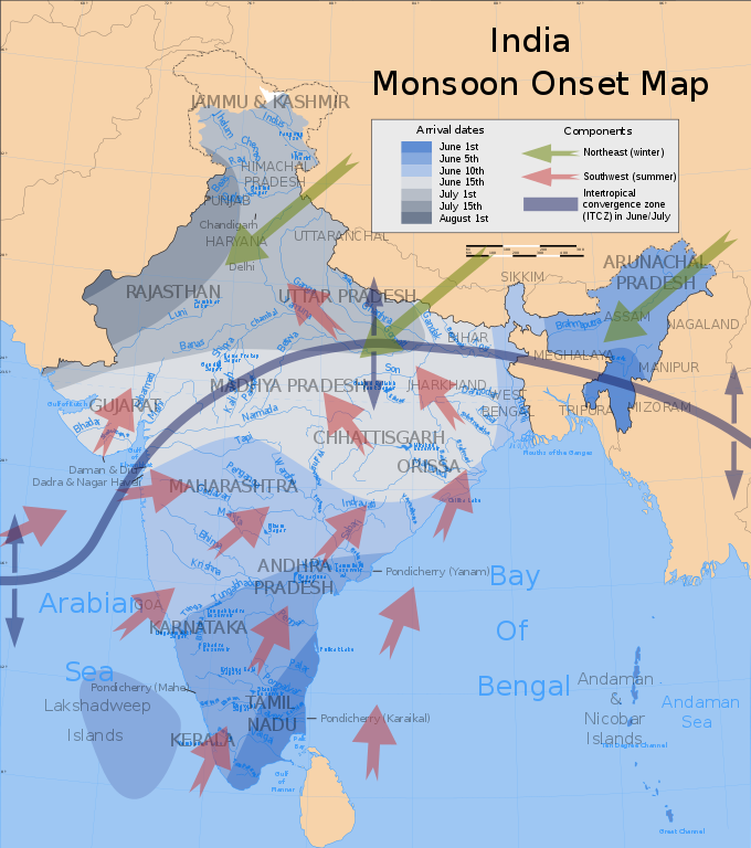
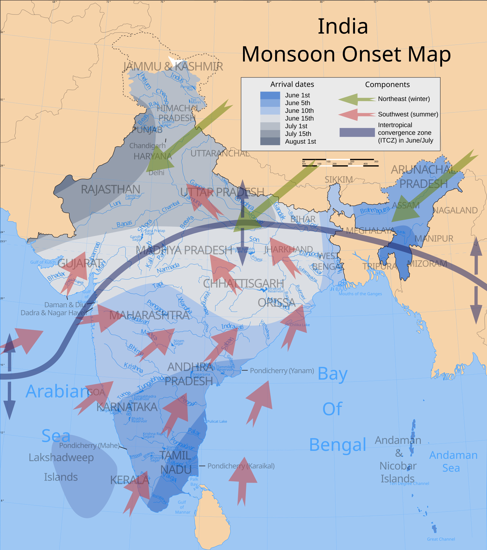
Map showing average onset (monsoon arrival) dates and wind directions prevalent during India's southwest summer monsoon. |
|||||||||
| Map legend |
 |
|||||||||
| Data | ||||||||||
| Jatorria |
Norberak egina Wind currents/ITCZ: Burroughs, WJ (1999), The Climate Revealed, Cambridge University Press, ISBN 0-521-77081-5, p. 138. |
|||||||||
| Sortzailea | ||||||||||
| Lizentzia (Fitxategi hau berrerabiltzen) |
Nik, lan honen egileak, argitaratzen dut ondorengo lizentzia pean: Fitxategi hau Creative Commons Attribution-Share Alike 3.0 Unported lizentziapean dago.
|
|||||||||
| Geotemporal data | ||||||||||
| Date depicted | second half of 20 century eta 21 century | |||||||||
| Spatial reference system | conic | |||||||||
| Bounding box |
|
|||||||||
| Georeferencing | If inappropriate please set warp_status = skip to hide. | |||||||||
| Archival data | ||||||||||
| Oharrak | Part of WikiProject India Maps | |||||||||
| SVG genesis | Fitxategi hau (bektore-irudia) hau Adobe Illustrator-ekin sortu da . |
|||||||||
| Beste bertsioak | Derivative works of this file: India southwest summer monsoon onset map-fr.svg | |||||||||


Notes
Depiction of India's borders
- The territorial boundaries of India are shown as per the actual ground situation in accordance with international practices followed by the United Nations ([2], [3]) and the National Geographic Society ([4], [5])
- This map is meant to be for illustrative purpose only and is not authenticated by official government sources. Please check the list of sources and references used to create the map for a measure of accuracy and verifiability.
- The usage of these maps in India, Pakistan and China are governed by different laws that restrict depictions of boundaries other than what is officially recognized by the state. Please check local laws and modify the map accordingly before use.
Explanation of disputed boundaries


- Boundary of Indian claim : The territory India claims is legally theirs, but the claim is disputed by China and Pakistan.
- Line of Control/Line of Conflict : The de facto administrative boundary recognised by the international community. This UN ceasefire line is considered as a temporary solution to an ongoing conflict since the departure of the British Raj.
Borders of disputed regions
The depicted extent of the former territory of the British Indian Empire, succeeded by Republic of India, may not be accepted by few countries as legal due to ongoing border disputes:
- The northern Himalayan region of the disputed territory Indian-administered Kashmir is claimed by India including (Pakistan-administered Kashmir) and the Chinese-occupied territory of (Ladakh plateau). Since 1972, it is divided between all three countries. See also Line of Control and Line of Actual Control.
- Siachen glacier (shown white) is an actively contested region between India and Pakistan. Since 1984, the region is under Indian control.
- The northeastern territory of Arunachal Pradesh is almost entirely claimed by China as part of its Tibetan territory.
- Minor areas of eastern Kashmir's Ladakh division, Himachal Pradesh and Uttarakhand on the Chinese frontier are claimed by China. These areas are under Indian control.
- A small area of Uttarakhand adjoining the Nepal border along the Sarda river is disputed between the two countries.
For a detailed map of all disputed regions in South Asia, see Image:India disputed areas map.svg
Internal borders
The borders of the state of Meghalaya, Assam and Arunachal Pradesh are shown as interpreted from the North-Eastern Areas (Reorganisation) Act, 1971, but has yet to be verified.
Territorial waters
The limit of the territorial waters of India extends to twelve nautical miles measured from the appropriate baseline. See this for more information.
| Annotations | This image is annotated: View the annotations at Commons |
Fitxategiaren historia
Data/orduan klik egin fitxategiak orduan zuen itxura ikusteko.
| Data/Ordua | Iruditxoa | Neurriak | Erabiltzailea | Iruzkina | |
|---|---|---|---|---|---|
| oraingoa | 22:57, 3 uztaila 2007 | | 1.639 × 1.852 (656 KB) | Saravask | {{WikiProject_India_Maps |Title=India climatic zone map english version |Description=Map (corrected) showing average onset (monsoon arrival) dates and wind directions prevalent during India's southwest summer monsoon. |Source=''Onset dates:'' [http://www. |
| 02:01, 24 apirila 2007 |  | 1.639 × 1.852 (656 KB) | Saravask | {{WikiProject_India_Maps |Title=India climatic zone map english version |Description=Map showing average onset (monsoon arrival) dates and wind directions prevalent during India's southwest summer monsoon. |Source=''Onset dates:'' [http://www.imdmumbai.go | |
| 01:19, 24 apirila 2007 |  | 1.639 × 1.852 (651 KB) | Saravask | {{WikiProject_India_Maps |Title=India climatic zone map english version |Description=Map showing average onset (monsoon arrival) dates and wind directions prevalent during India's southwest summer monsoon. |Source=''Onset dates:'' [http://www.imdmumbai.go | |
| 00:59, 24 apirila 2007 |  | 1.639 × 1.852 (651 KB) | Saravask | {{WikiProject_India_Maps |Title=India climatic zone map english version |Description=Map showing average onset (monsoon arrival) dates and wind directions prevalent during India's southwest summer monsoon. |Source=''Onset dates:'' [http://www.imdmumbai.go | |
| 16:00, 26 martxoa 2007 |  | 1.639 × 1.852 (649 KB) | Saravask | {{WikiProject_India_Maps |Title=India climatic zone map english version |Description=Map showing climatic zones in India (Köppen classification) |Source= [http://www.imdmumbai.gov.in/Onset.htm Normal dates of onset of | |
| 15:48, 26 martxoa 2007 |  | 1.639 × 1.852 (649 KB) | Saravask | {{WikiProject_India_Maps |Title=India climatic zone map english version |Description=Map showing climatic zones in India (Köppen classification) |Source= [http://www.imdmumbai.gov.in/Onset.htm Normal dates of onset of | |
| 15:27, 26 martxoa 2007 |  | 1.639 × 1.852 (649 KB) | Saravask | {{WikiProject_India_Maps |Title=India climatic zone map english version |Description=Map showing climatic zones in India (Köppen classification) |Source= [http://cee45q.stanford.edu/2003/briefing_book/images/india_cli |
Irudira dakarten loturak
Hurrengo orrialdeek dute fitxategi honetarako lotura:
Fitxategiaren erabilera orokorra
Hurrengo beste wikiek fitxategi hau darabilte:
- ar.wikipedia.org proiektuan duen erabilera
- bh.wikipedia.org proiektuan duen erabilera
- ca.wikipedia.org proiektuan duen erabilera
- cs.wikipedia.org proiektuan duen erabilera
- de.wikipedia.org proiektuan duen erabilera
- dty.wikipedia.org proiektuan duen erabilera
- el.wikipedia.org proiektuan duen erabilera
- en.wikipedia.org proiektuan duen erabilera
- en.wikibooks.org proiektuan duen erabilera
- fa.wikipedia.org proiektuan duen erabilera
- fr.wikipedia.org proiektuan duen erabilera
- hi.wikipedia.org proiektuan duen erabilera
- hu.wikipedia.org proiektuan duen erabilera
- hy.wikipedia.org proiektuan duen erabilera
- incubator.wikimedia.org proiektuan duen erabilera
- it.wikipedia.org proiektuan duen erabilera
- it.wikibooks.org proiektuan duen erabilera
- ja.wikipedia.org proiektuan duen erabilera
- kn.wikipedia.org proiektuan duen erabilera
- mk.wikipedia.org proiektuan duen erabilera
- ml.wikipedia.org proiektuan duen erabilera
- ms.wikipedia.org proiektuan duen erabilera
- ne.wikipedia.org proiektuan duen erabilera
- nl.wikipedia.org proiektuan duen erabilera
- nn.wikipedia.org proiektuan duen erabilera
- pa.wikipedia.org proiektuan duen erabilera
- pnb.wikipedia.org proiektuan duen erabilera
- pt.wikipedia.org proiektuan duen erabilera
Ikus fitxategi honen erabilpen global gehiago.