
Fitxategi:Iraqi Kurdistan in Iraq (de-facto and disputed hatched).svg

SVG fitxategi honen PNG aurreikuspenaren tamaina: 589 × 600 pixel. Bestelako bereizmenak: 236 × 240 pixel | 471 × 480 pixel | 754 × 768 pixel | 1.005 × 1.024 pixel | 2.011 × 2.048 pixel | 1.241 × 1.264 pixel.
Bereizmen handikoa (SVG fitxategia, nominaldi 1.241 × 1.264 pixel, fitxategiaren tamaina: 545 KB)
Fitxategi hau Wikimedia Commonsekoa da. Hango deskribapen orriko informazioa behean duzu. |
Laburpena
| Deskribapena |
Bân-lâm-gú: Kurdistan tī Iraq ê ūi-tì
Iraq koaⁿ-hong tēng ê Kurdistan Tē-he̍k Iraq Kurdistan khòng-chè ê thó͘-tē Iraq Kurdistan chú-tiuⁿ ê thó͘-tē Iraq kî-tha pō͘-hūn Català: Kurdistan Iraquí
Límits oficials de la regió kurda Territori controlat pel Kurdistan Iraquí Territory reivindicat pel Kurdistan Iraquí Dansk: Kort over Irakisk Kurdistan i Irak
Officielle grænser for Regionen Irakisk Kurdistan Andre områder kontrolleret af Irakisk Kurdistan Territorier som Irakisk Kurdistan gør krav på Øvrige Irak Deutsch: Die Lage Kurdistans im Irak
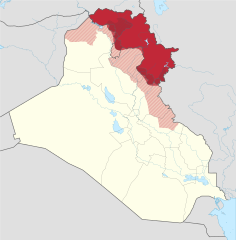
Offizielles Gebiet der Autonomen Region Kurdistan Eingegliederte Gebiete (nicht offiziell anerkannt) Von der Autonomen Region Kurdistans beanspruchte und besetzte Gebiete Von der Autonomen Region Kurdistans beanspruchte Gebiete Der Rest des Iraks Grenzen der Autonomen Region Kurdistans (inkl. der eingegliederten Gebiete) Grenze vor 2014 English: Location of Kurdistan in Iraq
Borders of the Kurdistan Region (disputed) Pre-2014 borders Recognised territory of the Kurdistan Region Disputed territory incorporated into the Kurdistan Region Other territory claimed and controlled by the Kurdistan Regional Government (approximate) Other territory claimed by the Kurdistan Regional Government Rest of Iraq Español: Ubicación de Kurdistan Iraquí
Fronteras oficiales de la región. Territorio ocupado por el Kurdistan Iraquí Territorio reclamado por el Kurdistan Iraquí. El resto de Irak. Français : Le Kurdistan irakien en Irak
Frontières officielles du Kurdistan irakien Territoire incorporé par le Kurdistan irakien Territoire revendiqué par le Kurdistan irakien Reste de l'Irak Italiano: Ubicazione del Kurdistan in Iraq
Confini della Regione del Kurdistan (contesi) Confini precedenti al 2014 Territorio riconosciuto ufficialmente della Regione del Kurdistan Territorio conteso incorporato nella Regione del Kurdistan Altri territori reclamati e amministrati dal governo regionale curdo (approssimativi) Altri territori reclamati dal governo regionale curdo Il resto dell'Iraq Magyar: Iraki Kurdisztán területe Irakon belül
Iraki Kurdisztán hivatalos területe a kurdok által elfoglalt terület (nem hivatalos) Iraki Kurdisztán által igényelt és elfoglalt terület Iraki Kurdisztán által igényelt terület Irak maradék területe Kurdisztáni Autonóm Régió határa A határ 2014 előtt Nederlands: Ligging van Koerdistan in Irak
Officiële grondgebied van Iraaks-Koerdistan Gebied ingelijfd door Iraaks-Koerdistan Gebied opgeëist door Iraaks-Koerdistan Overig Irak Suomi: Kurdistanin sijainti Irakissa
Irakin Kurdistanin autonominen alue Irakin Kurdistaniin kuuluvat alueet Irakin Kurdistanin vaatimat alueet Irakin valtion hallitsemat alueet Русский: Курдистан на карте Ирака
Официальные границы автономного региона Иракский Курдистан Территория, контролируемая силами Иракского Курдистана Территория, на которую претендует Иракский Курдистан Прочие территории Ирака 日本語: イラク領クルド人自治区 イラク
イラク中央政府が公式に定めたクルド人自治区の領域 イラク・クルド自治政府が併合し実効支配している領域 イラク・クルド自治政府が領有を主張する領域 その他のイラク国土 فارسی : اقلیم کردستان عراق
منطقهٔ رسمی کردستان عراق (در دست دولت کردستان) بخشهای اشغالشده توسط کردستان عراق دیگر بخشهای موردادعای کردستان عراق (در دست دولت مرکزی یا در اشغال داعش) دیگر منطقههای عراق |
||||
| Data | |||||
| Jatorria | |||||
| Egilea |
Spesh531, TUBS |
||||
| Beste bertsioak |
|
||||
| SVG genesis | Fitxategi hau (bektore-irudia) hau Inkscape-ekin sortu da NordNordWest-rako.
. |
||||
.svg)
.svg)
.svg)
.svg)
.svg)
.svg)
.svg)

-en.svg)

.svg)
.svg)
.svg)

_(US48).svg)
_(small_islands_magnified)_(-mini_map_-rivers).svg)
.svg)
_(extra_close)_(US48).svg)
.svg)
_(zoom).svg)

.svg)


_(UNMIK).svg)
.svg)
_(disputed_hatched).svg)
_(claimed_and_disputed_hatched).svg)
.svg)
.svg)
_(%2Ball_claims_hatched).svg)

.svg)
_(shade).svg)
_(shade)_(special_marker).svg)
_(-mini_map).svg)
_(-mini_map).svg)
_(-mini_map).svg)


.svg)

.svg)
.svg)
Lizentzia
Fitxategi hau Creative Commons Attribution-Share Alike 3.0 Unported lizentziapean dago.
- Askea zara:
- partekatzeko – lana kopiatzeko, banatzeko eta bidaltzeko
- birnahasteko – lana moldatzeko
- Ondorengo baldintzen pean:
- eskuduntza – Egiletza behar bezala aitortu behar duzu, lizentzia ikusteko esteka gehitu, eta ea aldaketak egin diren aipatu. Era egokian egin behar duzu hori guztia, baina inola ere ez egileak zure lana edo zure erabilera babesten duela irudikatuz.
- berdin partekatu – Lan honetan oinarrituta edo aldatuta berria eraikitzen baduzu, emaitza lana hau bezalako lizentzia batekin argitaratu behar duzu.
References
Official territory and governorate borders
- http://www.krso.net/Default.aspx?page=article&id=1142
- http://www.economist.com/images/20070908/CMA980.gif
Claimed territory
- http://www.aina.org/reports/pcok.pdf (page 13)
- http://www.economist.com/images/20070908/CMA980.gif
- http://photos1.blogger.com/blogger/6564/131/1600/Kurdistan_july05_claimed-767346.jpg
- http://images.fastcompany.com/magazine/144/feature-84-Kurdistan-OilMap-pop.jpg
- http://news.bbcimg.co.uk/media/images/76876000/gif/_76876578_iraq_kurdistan_624.gif
Fitxategiaren historia
Data/orduan klik egin fitxategiak orduan zuen itxura ikusteko.
.svg&dir=prev)
.svg&offset=20170928132057)
.svg&offset=&limit=20)
.svg&offset=&limit=50)
.svg&offset=&limit=100)
.svg&offset=&limit=250)
.svg&offset=&limit=500)
| Data/Ordua | Iruditxoa | Neurriak | Erabiltzailea | Iruzkina | |
|---|---|---|---|---|---|
| oraingoa | 01:01, 20 uztaila 2018 | | 1.241 × 1.264 (545 KB) | Rob984 | dashed official KRG border on the basis that it's disputed by Baghdad. |
| 21:05, 19 uztaila 2018 |  | 1.241 × 1.264 (548 KB) | Rob984 | Also Iraqi forces took Khanaqin in October as well | |
| 20:12, 19 uztaila 2018 |  | 1.241 × 1.264 (549 KB) | Rob984 | The town of Makhmur was taken over by Iraqi forces last year. Also the frontier in Kirkuk likely corresponds to the 2003 green line, not the administrative border, since Iraq only requested the Kurdish forces withdraw to the green line. | |
| 00:34, 27 urtarrila 2018 |  | 1.241 × 1.264 (549 KB) | 0ali1 | Update 26/01/2018, minor fixes | |
| 01:55, 25 urria 2017 |  | 1.241 × 1.264 (549 KB) | Rob984 | Federal government has reassumed control over most (if not all) of the Kirkuk province. | |
| 18:03, 24 urria 2017 |  | 1.241 × 1.264 (549 KB) | Rob984 | Scaled back changes around Machmur. Peshmerga have not withdrawn from the town, despite earlier reports suggesting so. | |
| 14:26, 20 urria 2017 |  | 1.241 × 1.264 (549 KB) | Rob984 | Update following Peshmerga withdrawal from a number of areas. Note Kurdish militias (eg PKK, YBS, etc.) have not withdrew from all areas, but they are not under KRG control. Approximate area, will need to be updated. | |
| 22:20, 12 urria 2017 |  | 1.241 × 1.264 (555 KB) | Spesh531 | Update now that ISIS is no longer on the Iraqi Kurdish-Iraqi proper border | |
| 16:28, 28 iraila 2017 |  | 1.241 × 1.264 (555 KB) | Rob984 | another minor fix | |
| 15:20, 28 iraila 2017 |  | 1.241 × 1.264 (555 KB) | Rob984 | minor fix |
Irudira dakarten loturak
Ez dago fitxategi hau darabilen orririk.
Fitxategiaren erabilera orokorra
Hurrengo beste wikiek fitxategi hau darabilte:
- als.wikipedia.org proiektuan duen erabilera
- ar.wikipedia.org proiektuan duen erabilera
- arz.wikipedia.org proiektuan duen erabilera
- azb.wikipedia.org proiektuan duen erabilera
- az.wikipedia.org proiektuan duen erabilera
- ba.wikipedia.org proiektuan duen erabilera
- bcl.wikipedia.org proiektuan duen erabilera
- be-tarask.wikipedia.org proiektuan duen erabilera
- be.wikipedia.org proiektuan duen erabilera
- bg.wikipedia.org proiektuan duen erabilera
- bn.wikipedia.org proiektuan duen erabilera
- br.wikipedia.org proiektuan duen erabilera
- bs.wikipedia.org proiektuan duen erabilera
- ceb.wikipedia.org proiektuan duen erabilera
- ckb.wikipedia.org proiektuan duen erabilera
- cs.wikipedia.org proiektuan duen erabilera
- cy.wikipedia.org proiektuan duen erabilera
- da.wikipedia.org proiektuan duen erabilera
- de.wikipedia.org proiektuan duen erabilera
- diq.wikipedia.org proiektuan duen erabilera
- el.wikipedia.org proiektuan duen erabilera
- el.wikivoyage.org proiektuan duen erabilera
- en.wikipedia.org proiektuan duen erabilera
- Iraqi Kurdistan
- Minorities in Iraq
- 2008 Turkish incursion into northern Iraq
- List of active separatist movements in Asia
- Disputed territories of northern Iraq
- Northern Iraq offensive (June 2014)
- Talk:Iraqi Kurdistan/Archive 2
- Ba'athist Arabization campaigns in northern Iraq
- COVID-19 pandemic in the Kurdistan Region
- eo.wikipedia.org proiektuan duen erabilera
Ikus fitxategi honen erabilpen global gehiago.
.svg)
.svg)