
Fitxategi:Island of Ireland location map Kerry.svg

SVG fitxategi honen PNG aurreikuspenaren tamaina: 481 × 599 pixel. Bestelako bereizmenak: 192 × 240 pixel | 385 × 480 pixel | 616 × 768 pixel | 822 × 1.024 pixel | 1.643 × 2.048 pixel | 1.450 × 1.807 pixel.
Bereizmen handikoa (SVG fitxategia, nominaldi 1.450 × 1.807 pixel, fitxategiaren tamaina: 642 KB)
Fitxategi hau Wikimedia Commonsekoa da. Hango deskribapen orriko informazioa behean duzu. |
| Deskribapena |
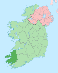
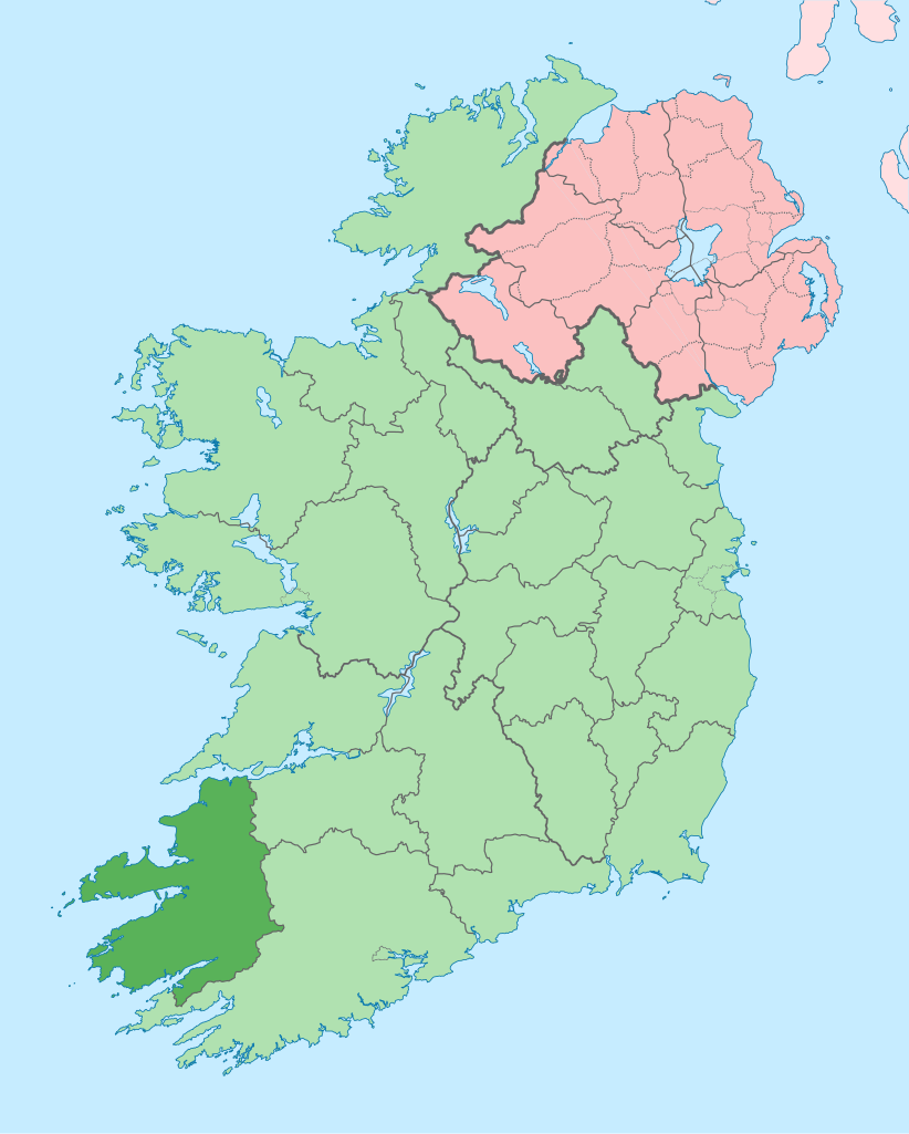
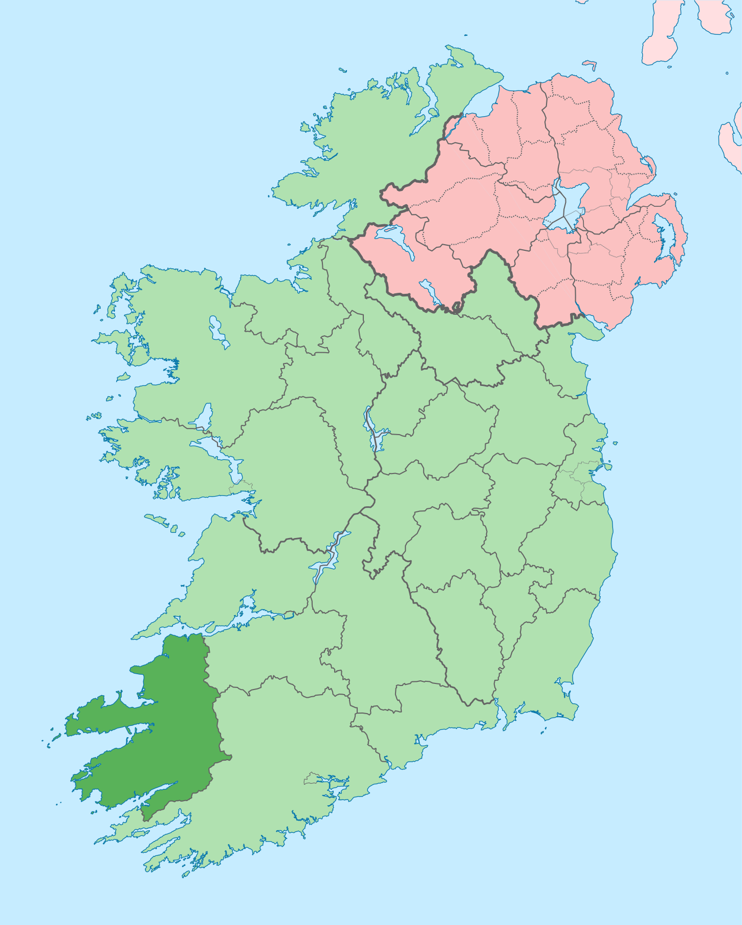
English: The island of Ireland, showing international border between Ireland and Northern Ireland, traditional provinces, traditional counties, and local authority areas in Ireland and Northern Ireland. |
| Data | (UTC) |
| Jatorria | |
| Egilea |
|
| This is a retouched picture, which means that it has been digitally altered from its original version. Modifications: Coloured in regions with county of article highlighted. The original can be viewed here: Island of Ireland location map.svg:
|
Nik, lan honen egileak, argitaratzen dut ondorengo lizentzia pean:
Fitxategi hau Creative Commons Attribution-Share Alike 3.0 Unported lizentziapean dago.
- Askea zara:
- partekatzeko – lana kopiatzeko, banatzeko eta bidaltzeko
- birnahasteko – lana moldatzeko
- Ondorengo baldintzen pean:
- eskuduntza – Egiletza behar bezala aitortu behar duzu, lizentzia ikusteko esteka gehitu, eta ea aldaketak egin diren aipatu. Era egokian egin behar duzu hori guztia, baina inola ere ez egileak zure lana edo zure erabilera babesten duela irudikatuz.
- berdin partekatu – Lan honetan oinarrituta edo aldatuta berria eraikitzen baduzu, emaitza lana hau bezalako lizentzia batekin argitaratu behar duzu.
Jatorrizko igoera erregistroa
This image is a derivative work of the following images:
- File:Island_of_Ireland_location_map.svg licensed with Cc-by-sa-3.0
- 2010-03-06T20:43:33Z Rannpháirtí anaithnid 1450x1807 (679207 Bytes) Fix incorrectly coloured isands.
- 2010-03-03T22:19:29Z Rannpháirtí anaithnid 1450x1807 (679744 Bytes) {{Information |Description={{de|Positionskarte von [[:de:Irland|Irland]]}} Quadratische Plattkarte, N-S-Streckung 170 %. Geographische Begrenzung der Karte: * N: 55.6° N * S: 51.2° N * W: 11.0° W * O: 5.0° W {{en|Location
Uploaded with derivativeFX
Fitxategiaren historia
Data/orduan klik egin fitxategiak orduan zuen itxura ikusteko.
| Data/Ordua | Iruditxoa | Neurriak | Erabiltzailea | Iruzkina | |
|---|---|---|---|---|---|
| oraingoa | 17:58, 26 ekaina 2020 | | 1.450 × 1.807 (642 KB) | Chipmunkdavis | Per the Local Government Reform Act 2014, joining both Tipperarys and both Waterfords (and removing Limerick City code). Colouring in islands, cleaning up and grouping code to remove stray objects and show Galway and Lough Ree. |
| 02:48, 19 uztaila 2010 |  | 1.450 × 1.807 (821 KB) | Mabuska | {{Information |Description={{en|The island of Ireland, showing international border between Northern Ireland and Republic of Ireland, traditional provinces, traditional counties, and local authority areas in the Republic of Ireland and Northern Ireland.}} |
Irudira dakarten loturak
Hurrengo orrialdeek dute fitxategi honetarako lotura:
- Abbeydorney
- An Clochán
- An Daingean
- An Fheothanach
- Annascaul
- Ard na Caithne
- Ardfert
- Baile an Fheirtéaraigh
- Baile na Sceilge
- Baile na nGall
- Ballybunion
- Ballyduff (Kerry konderria)
- Ballyheigue
- Ballylongford
- Ballymacelligott
- Ballyseedy
- Beaufort (Kerry konderria)
- Blennerville
- Brosna (Kerry konderria)
- Caherdaniel
- Cahersiveen
- Castlecove
- Castlegregory
- Castleisland
- Castlemaine (Kerry konderria)
- Cathair Bó Sine
- Causeway
- Ceann Trá
- Coolgarriv
- Cuas an Bhodaigh
- Currans
- Currow
- Cé Bhréannain
- Derrymore (Kerry konderria)
- Derrynane
- Duagh
- Dún Chaoin
- Dún Síon
- Fahamore
- Farranfore
- Fenit
- Finuge
- Fossa (Kerry konderria)
- Gneeveguilla
- Kenmare
- Kerry konderria
- Kilderry
- Kilflynn
- Kilgarvan
- Killarney
- Killorglin
- Kilmoyley
- Knightstown (Kerry konderria)
- Knocknagoshel
- Lios Póil
- Lisselton
- Listowel
- Lixnaw
- Milltown (Kerry konderria)
- Moyvane
- Portmagee
- Rathmore
- Scraggane
- Sneem
- Tarbert (Kerry konderria)
- Tarmon
- Templenoe
- Tralee
- Tuosist
- Waterville (Irlanda)
- Lankide:Euskaldunaa
- Txantiloi:Kerry konderriko udalerriak
- Wikiproiektu:Irlanda, Gales eta Eskoziako udalerriak
Fitxategiaren erabilera orokorra
Hurrengo beste wikiek fitxategi hau darabilte:
- ar.wikipedia.org proiektuan duen erabilera
- ast.wikipedia.org proiektuan duen erabilera
- bg.wikipedia.org proiektuan duen erabilera
- br.wikipedia.org proiektuan duen erabilera
- An Daingean
- Trá Lí
- Mainistir Ó dTorna
- Abhainn an Scáil
- Ard Fhearta
- Baile na nGall
- Baile an Sceilg
- Dairbhre
- An Baile Dubh
- Baile an Fheirtéaraigh
- Baile Uí Thaidhg
- Baile Mhic Eilegóid
- Cathair Uí Mhóráin
- Patrom:Kontelezh Ciarraí
- Brosnach
- Cathair Dhónaill
- Cathair Saidhbhín
- Béal Átha Longfoirt
- An Siopa Dubh
- Caisleán Ghriaire
- ca.wikipedia.org proiektuan duen erabilera
- Comtat de Kerry
- Killarney
- Tralee
- Kenmare
- Plantilla:Comtat Kerry
- Listowel
- Baile an Fheirtéaraigh
- Baile an Sceilg
- Ceann Trá
- An Daingean
- Dún Chaoin
- Feothanach
- An Clochán
- Cé Bhréannain
- Lios Póil
- Cathair Dónall
- Baile na nGall
- Abhainn an Scáil
- Ballylongford
- Tarbert
- Ballybunion
- An Fosadh
- Baile an Mhuilinn (Kerry)
- An Com
- ceb.wikipedia.org proiektuan duen erabilera
- cs.wikipedia.org proiektuan duen erabilera
Ikus fitxategi honen erabilpen global gehiago.