
Fitxategi:Mons, Hérault 01.jpg

Bereizmen handikoa ((6.016 × 3.760 pixel, fitxategiaren tamaina: 18,25 MB, MIME mota: image/jpeg))
Fitxategi hau Wikimedia Commonsekoa da. Hango deskribapen orriko informazioa behean duzu. |
Laburpena
| Deskribapena |
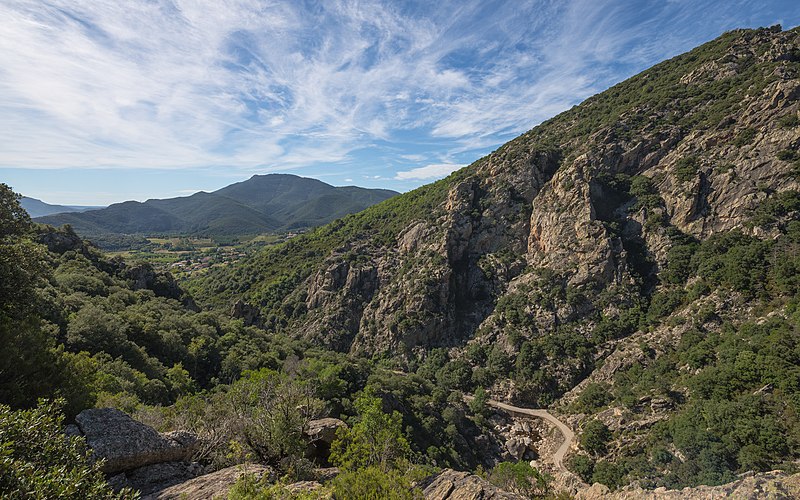
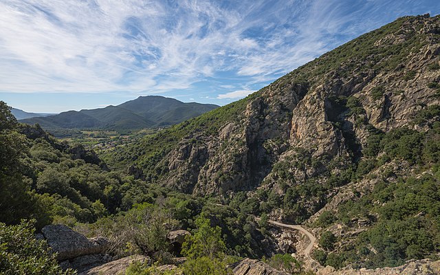
Français : L'extrémité sud des Gorges d'Héric, en haut à droite le Pas du Cabalet (543m), en contrebas au premier plan le Ruisseau d'Héric, dans le fond à gauche la vallée du Jaur et derrière cette dernière le Mont Naudech (753m). Mons, Hérault, France. Parc naturel régional du Haut-Languedoc. English: The Southern end of the Gorges d'Héric, at above on the right the Pas du Cabalet (543m), below in the foreground the Ruisseau d'Héric, in the background in the left the Jaur Valley and behind it the Mont Naudech (753m). Mons, Hérault, France. Haut-Languedoc Regional Natural Park. |
| Data | Taken on 2013ko urriaren 1ea, 12:10:06 |
| Jatorria | Norberak egina |
| Egilea | Christian Ferrer |
| Lizentzia (Fitxategi hau berrerabiltzen) |
Nik, lan honen egileak, argitaratzen dut ondorengo lizentzia pean: Fitxategi hau Creative Commons Attribution-Share Alike 3.0 Unported lizentziapean dago.
|
| Kameraren kokapena | | Irudi hau eta gehiago beraien kokapenekin hurrengo lekuetan: OpenStreetMap |
|---|
|

| Annotations | This image is annotated: View the annotations at Commons |

|
This image has been assessed under the valued image criteria and is considered the most valued image on Commons within the scope: Southern end of the Gorges d'Héric. View from Northeast in 2013.. You can see its nomination here. |
Fitxategiaren historia
Data/orduan klik egin fitxategiak orduan zuen itxura ikusteko.
| Data/Ordua | Iruditxoa | Neurriak | Erabiltzailea | Iruzkina | |
|---|---|---|---|---|---|
| oraingoa | 07:50, 12 urria 2013 | | 6.016 × 3.760 (18,25 MB) | Christian Ferrer | User created page with UploadWizard |
Irudira dakarten loturak
Hurrengo orrialdeek dute fitxategi honetarako lotura:
Fitxategiaren erabilera orokorra
Hurrengo beste wikiek fitxategi hau darabilte:
- ca.wikipedia.org proiektuan duen erabilera
- ceb.wikipedia.org proiektuan duen erabilera
- de.wikipedia.org proiektuan duen erabilera
- en.wikipedia.org proiektuan duen erabilera
- en.wikivoyage.org proiektuan duen erabilera
- es.wikipedia.org proiektuan duen erabilera
- fr.wikipedia.org proiektuan duen erabilera
- it.wikipedia.org proiektuan duen erabilera
- kk.wikipedia.org proiektuan duen erabilera
- lb.wikipedia.org proiektuan duen erabilera
- mg.wikipedia.org proiektuan duen erabilera
- ms.wikipedia.org proiektuan duen erabilera
- nl.wikipedia.org proiektuan duen erabilera
- oc.wikipedia.org proiektuan duen erabilera
- pl.wikipedia.org proiektuan duen erabilera
- pms.wikipedia.org proiektuan duen erabilera
- pt.wikipedia.org proiektuan duen erabilera
- ro.wikipedia.org proiektuan duen erabilera
- sv.wikipedia.org proiektuan duen erabilera
- uk.wikipedia.org proiektuan duen erabilera
- vi.wikipedia.org proiektuan duen erabilera
- vo.wikipedia.org proiektuan duen erabilera
- war.wikipedia.org proiektuan duen erabilera
- www.wikidata.org proiektuan duen erabilera