
Fitxategi:Muğla districts.png

Aurreikuspen honen neurria: 776 × 600 pixel. Bestelako bereizmenak: 311 × 240 pixel | 621 × 480 pixel | 994 × 768 pixel | 1.056 × 816 pixel.
Bereizmen handikoa ((1.056 × 816 pixel, fitxategiaren tamaina: 278 KB, MIME mota: image/png))
Fitxategi hau Wikimedia Commonsekoa da. Hango deskribapen orriko informazioa behean duzu. |
Laburpena
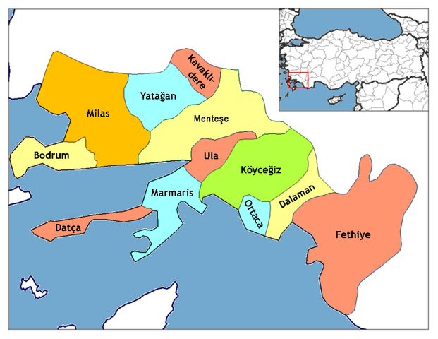
| Deskribapena | This is Map of the districts of Muğla province in Turkey. Created by Rarelibra 16:37, 4 December 2006 (UTC) for public domain use, using MapInfo Professional v8.5 and various mapping resources. Edited by One Homo Sapiens Corrected text where İ,Ş,ı,ğ,or ş occurs in name. Source: [statoids-com]. Increased font size and enhanced color differences among adjacent districts. |
| Data | 2007ko apirilaren 15a (Jatorrizko igoera-data) |
| Jatorria | No machine-readable source provided. Own work assumed (based on copyright claims). |
| Egilea | No machine-readable author provided. Denizz~commonswiki assumed (based on copyright claims). |
Lizentzia
| Nik, lan honen egile eskubideen jabeak, lan hau domeinu publikoan jartzen dut. Mundu osoan du eragina honek. Estatu batzuetan beharbada hori ez da legez posible izango. Halakoetan: Edonori ematen diot lan hau edozertarako erabiltzeko eskubidea, inolako baldintzarik gabe, legeak nahitaez ezarritako baldintzak izan ezik. |
Fitxategiaren historia
Data/orduan klik egin fitxategiak orduan zuen itxura ikusteko.
| Data/Ordua | Iruditxoa | Neurriak | Erabiltzailea | Iruzkina | |
|---|---|---|---|---|---|
| oraingoa | 12:10, 16 urria 2023 | | 1.056 × 816 (278 KB) | Alikam1896 | menteşe |
| 03:41, 29 abendua 2008 |  | 1.056 × 816 (235 KB) | One Homo Sapiens | Corrected text where İ,Ş,ı,ğ,or ş occurs in name. Source: [statoids-com]. Increased font size and enhanced color differences among adjacent districts. | |
| 23:10, 15 apirila 2007 |  | 776 × 600 (125 KB) | Denizz~commonswiki | == Summary == Map of the districts of Muğla province in Turkey. Created by Rarelibra 16:37, 4 December 2006 (UTC) for public domain use, using MapInfo Professional v8.5 and various mapping resources. == Licensing == {{PD-self}} |
Irudira dakarten loturak
Hurrengo orrialdeek dute fitxategi honetarako lotura:
Fitxategiaren erabilera orokorra
Hurrengo beste wikiek fitxategi hau darabilte:
- ar.wikipedia.org proiektuan duen erabilera
- azb.wikipedia.org proiektuan duen erabilera
- ce.wikipedia.org proiektuan duen erabilera
- de.wikipedia.org proiektuan duen erabilera
- diq.wikipedia.org proiektuan duen erabilera
- en.wikipedia.org proiektuan duen erabilera
- en.wiktionary.org proiektuan duen erabilera
Ikus fitxategi honen erabilpen global gehiago.