
Fitxategi:Nueva Esparta Mapa Vial.svg

SVG fitxategi honen PNG aurreikuspenaren tamaina: 800 × 555 pixel. Bestelako bereizmenak: 320 × 222 pixel | 640 × 444 pixel | 1.024 × 711 pixel | 1.280 × 889 pixel | 2.560 × 1.778 pixel | 3.612 × 2.508 pixel.
Bereizmen handikoa (SVG fitxategia, nominaldi 3.612 × 2.508 pixel, fitxategiaren tamaina: 1,42 MB)
Fitxategi hau Wikimedia Commonsekoa da. Hango deskribapen orriko informazioa behean duzu. |
Laburpena
| Objektuaren kokapena | | Irudi hau eta gehiago beraien kokapenekin hurrengo lekuetan: OpenStreetMap |
|---|
| Deskribapena |
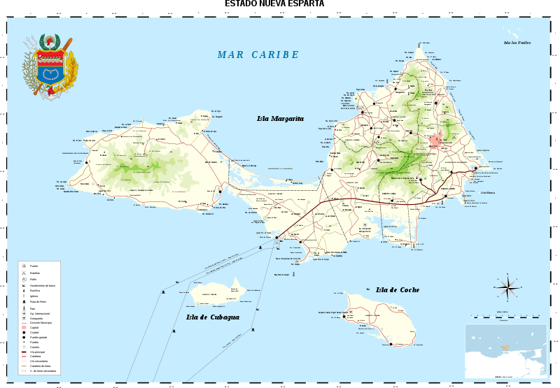
Aragonés: stato Nueba Esparta Bahasa Indonesia: Nueva Esparta Català: Estat de Nueva Esparta Dansk: Nueva Esparta Deutsch: Karte von Nueva Esparta English: Nueva Esparta (New Sparta) is one of the 23 states (estados) of Venezuela. It comprises Margarita Island (by far the largest and most important island), Coche, and uninhabited Cubagua.
The state is the smallest one in area, and is located off the northeast Caribbean coast of Venezuela. It is the only insular state of Venuezuela. Its name comes from the heroísm shown by its inhabitants during the Venezuelan War of Independence, deemed similar to that of the Spartan soldiers of Ancient Greece. The main island of Margarita alone has an area of 934 km². In 1909 the state was constituted and in 1947 the island of Cubagua was added. Its capital city is La Asunción, but the main urban center is Porlamar. Español: Nueva Esparta es un estado federal de Venezuela, ubicado al noreste del país, siendo el único Estado Federal insular y el de menor superficie de la nación.
El estado posee gran cantidad de monumentos históricos, en la iglesia de Santa Ana fue declarada la Tercera República de Venezuela, y, Simón Bolívar, su presidente. El Estado fue designado con ese nombre a partir del 12 de mayo de 1817, con el propósito de hacer un homenaje al heroísmo de los habitantes de la isla de Margarita durante la guerra de Independencia de Venezuela, calificado como "Heroísmo espartano", porque hizo recordar la valentía de los ciudadanos de la capital de la porción de Laconia (Esparta), en la península del Peloponeso, en la antigua Grecia. Aquí nacieron Luis Beltrán Prieto Figueroa, Santiago Mariño y otros grandes personajes de la historia regional y nacional. Français : L’État de Nueva Esparta « Nouvelle Sparte » est un des 23 États (estados) du Venezuela. Il comprend les îles de Margarita (de loin la plus grande et plus importante, avec une surface de 934 km² à elle seule), Coche et Cubagua (inhabitée).
C’est le seul État insulaire du Venezuela, et le plus petit de la région, il est localisé sur la côte antillaise au nord-est du Venezuela. Son nom vient de l’héroïsme montré par ses habitants durant la guerre d’indépendance vénézuelienne, jugé semblable à celui des soldats spartiates de la Grèce antique. L’État a été constitué en 1909 et l’île de Cubagua a été ajoutée en 1947. Sa ville capitale est Asunción, mais le principal centre urbain est Porlamar. Italiano: Nueva Esparta Kernowek: Nueva Esparta Nederlands: Nueva Esparta Norsk bokmål: Nueva Esparta Norsk nynorsk: Nueva Esparta Polski: Nueva Esparta Português: Estado de Nueva Esparta Svenska: Nueva Esparta (Nya Sparta), en delstat i Venezuela. Русский: Нуэва-Эспарта Тоҷикӣ: Иёлоти Нуэва Эспарта 日本語: ベネズエラ、ヌエバ・エスパルタ州の地図。 中文: 新埃斯帕塔州 |
|||
| Data | ||||
| Jatorria |
Norberak egina, data obtained traveling across the zone with a GPS.
|
|||
| Egilea | Wilfredor | |||
| Lizentzia (Fitxategi hau berrerabiltzen) |
|
|||
| Beste bertsioak |
Derivative works of this file: |
|||
| SVG genesis | Fitxategi hau (bektore-irudia) hau Inkscape-ekin sortu da .
. |


Irudi hau Eguneko irudi bezala hautatua izan da 2009ko abenduaren 14a-(e)an. Honela izan zen deskribatua: English: Map of Nueva Esparta, one of the 23 states of Venezuela. Beste hizkuntzak:
Bosanski: Karta Nueva-e Esparta-e, jedne od 23 države Venecuele Deutsch: Karte des venezolanischen Bundesstaates Nueva Esparta English: Map of Nueva Esparta, one of the 23 states of Venezuela. Nederlands: Spaanstalige topografische kaart van de Venezolaanse provincie Nueva Esparta, bestaande uit het grote eiland Isla Margarita en de kleine eilanden Coche en Cubagua. De naam "Nieuw Sparta" verwijst naar de heldhaftigheid van de eilanders tijdens de Venezolaanse Onafhankelijkheidsoorlog. De hoofdstad is La Asunción, maar de belangrijkste stad is Porlamar. Македонски: Карта на Нуева Еспарта, една од 23-те држави на Венецуела. বাংলা : নুয়েভা এসপারাটা-এর মানচিত্র। এটি ভেনেজুয়েলার ২৩টি অঙ্গরাজ্যের একটি। |
|

Fitxategiaren historia
Data/orduan klik egin fitxategiak orduan zuen itxura ikusteko.
| Data/Ordua | Iruditxoa | Neurriak | Erabiltzailea | Iruzkina | |
|---|---|---|---|---|---|
| oraingoa | 19:59, 11 martxoa 2016 | | 3.612 × 2.508 (1,42 MB) | Wilfredor | update coat of arms |
| 23:26, 13 urria 2015 |  | 3.612 × 2.508 (1,94 MB) | Wilfredor | Adding more information | |
| 21:03, 1 azaroa 2008 |  | 3.612 × 2.508 (1,94 MB) | Wilfredor | {{Information |Description= |Source= |Date= |Author= |Permission= |other_versions= }} |
Irudira dakarten loturak
Ez dago fitxategi hau darabilen orririk.
Fitxategiaren erabilera orokorra
Hurrengo beste wikiek fitxategi hau darabilte:
- ba.wikipedia.org proiektuan duen erabilera
- bn.wikipedia.org proiektuan duen erabilera
- br.wikipedia.org proiektuan duen erabilera
- ca.wikipedia.org proiektuan duen erabilera
- crh.wikipedia.org proiektuan duen erabilera
- cs.wikipedia.org proiektuan duen erabilera
- cv.wikipedia.org proiektuan duen erabilera
- da.wikipedia.org proiektuan duen erabilera
- de.wikipedia.org proiektuan duen erabilera
- de.wikivoyage.org proiektuan duen erabilera
- el.wikipedia.org proiektuan duen erabilera
- en.wikipedia.org proiektuan duen erabilera
- en.wikivoyage.org proiektuan duen erabilera
- es.wikipedia.org proiektuan duen erabilera
- Wikiproyecto Discusión:Venezuela/1
- Wikipedia:Candidatos a recursos destacados/Nueva Esparta Mapa Vial.svg
- Wikipedia:Candidatos a recursos destacados/Septiembre-2007
- Wikipedia:Recurso del día/enero de 2008
- Plantilla:RDD/1
- Wikipedia:Imágenes destacadas/Diagramas, dibujos y mapas
- Wikipedia:Recurso del día/agosto de 2008
- Wikipedia:Recurso del día/1 - 100
- Wikipedia:Recurso del día/diciembre de 2009
- Wikipedia:Recurso del día/junio de 2011
- Wikipedia:Recurso del día/mayo de 2013
- Wikipedia:Recurso del día/diciembre de 2015
- Wikipedia:Recurso del día/marzo de 2018
- Wikipedia:Recurso del día/julio de 2020
- Wikipedia:Recurso del día/junio de 2023
- fr.wikipedia.org proiektuan duen erabilera
- fr.wikivoyage.org proiektuan duen erabilera
- gl.wikipedia.org proiektuan duen erabilera
- hu.wikipedia.org proiektuan duen erabilera
- it.wikipedia.org proiektuan duen erabilera
- ko.wikipedia.org proiektuan duen erabilera
- krc.wikipedia.org proiektuan duen erabilera
- lbe.wikipedia.org proiektuan duen erabilera
- mg.wikipedia.org proiektuan duen erabilera
- mk.wikipedia.org proiektuan duen erabilera
- os.wikipedia.org proiektuan duen erabilera
- pam.wikipedia.org proiektuan duen erabilera
- pl.wikipedia.org proiektuan duen erabilera
Ikus fitxategi honen erabilpen global gehiago.