
Fitxategi:Ottoman Provinces Of Present day Libya.png
Ez dago bereizmen handiagorik.
Ottoman_Provinces_Of_Present_day_Libya.png ((282 × 314 pixel, fitxategiaren tamaina: 22 KB, MIME mota: image/png))
Fitxategi hau Wikimedia Commonsekoa da. Hango deskribapen orriko informazioa behean duzu. |

|
Irudi hau birsortu beharko litzateke SVG irudi bektorial moduan. Honek abantaila asko ematen ditu, ikus Commons:Media for cleanup (ingelesez) informazio gehiagorako. Irudi honen SVG bertsioa eskuragarri badago, mesedez Commonsera igo. Igo ostean, ordezkatu txantiloi hau txantiloi honegatik {{vector version available|irudiaren izen berria.svg}} irudi honetan.
|
Laburpena
| Deskribapena |
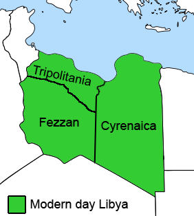
English: The Ottoman Turks conquered the country in the mid-16th century, and the three States or "Wilayat" of Tripolitania, Cyrenaica and Fezzan (which make up Libya) remained part of their empire with the exception of the virtual autonomy of the Karamanlis. The Karamanlis ruled from 1711 until 1835 mainly in Tripolitania, but had influence in Cyrenaica and Fezzan as well by the mid 18th century. |
||
| Data | |||
| Jatorria | self-made but based on this image on this image and this image | ||
| Egilea | Esemono; improved by Kirk (talk) | ||
| Lizentzia (Fitxategi hau berrerabiltzen) |
|
||
| Beste bertsioak |
Derivative works of this file:
   |
Fitxategiaren historia
Data/orduan klik egin fitxategiak orduan zuen itxura ikusteko.
| Data/Ordua | Iruditxoa | Neurriak | Erabiltzailea | Iruzkina | |
|---|---|---|---|---|---|
| oraingoa | 14:53, 24 abuztua 2011 | | 282 × 314 (22 KB) | Kirk979 | See discussion |
| 22:46, 11 apirila 2011 |  | 300 × 350 (35 KB) | ANGELUS | border | |
| 22:35, 11 apirila 2011 |  | 300 × 350 (39 KB) | ANGELUS | improved | |
| 19:35, 12 urria 2009 |  | 282 × 314 (22 KB) | Kirk979 | corrections | |
| 13:00, 1 martxoa 2009 |  | 282 × 314 (29 KB) | Kirk979 | corrections | |
| 15:43, 17 apirila 2008 |  | 282 × 314 (25 KB) | Esemono | Category:Maps of Libya Category:Map images that should use vector graphics |
Irudira dakarten loturak
Hurrengo orrialdeek dute fitxategi honetarako lotura:
Fitxategiaren erabilera orokorra
Hurrengo beste wikiek fitxategi hau darabilte:
- ar.wikipedia.org proiektuan duen erabilera
- azb.wikipedia.org proiektuan duen erabilera
- az.wikipedia.org proiektuan duen erabilera
- be.wikipedia.org proiektuan duen erabilera
- bg.wikipedia.org proiektuan duen erabilera
- bs.wikipedia.org proiektuan duen erabilera
- ca.wikipedia.org proiektuan duen erabilera
- cs.wikipedia.org proiektuan duen erabilera
- da.wikipedia.org proiektuan duen erabilera
- el.wikipedia.org proiektuan duen erabilera
- en.wikipedia.org proiektuan duen erabilera
- Cyrenaica
- Districts of Libya
- Fezzan
- Tripolitania
- Governorates of Libya
- Subdivisions of Libya
- Provinces of Libya
- Postage stamps and postal history of Tripolitania
- Kingdom of Libya
- Postage stamps and postal history of Cyrenaica
- Postage stamps and postal history of Libya
- Postage stamps and postal history of Fezzan and Ghadames
- Template:Regions of Libya
- Category:Regions of Libya
- Revenue stamps of Libya
- Tripolitania (province of Libya)
- Cyrenaica province
- Fezzan province
Ikus fitxategi honen erabilpen global gehiago.