
Fitxategi:Scg01.png

Aurreikuspen honen neurria: 409 × 600 pixel. Bestelako bereizmenak: 163 × 240 pixel | 327 × 480 pixel | 818 × 1.200 pixel.
Bereizmen handikoa ((818 × 1.200 pixel, fitxategiaren tamaina: 56 KB, MIME mota: image/png))
Fitxategi hau Wikimedia Commonsekoa da. Hango deskribapen orriko informazioa behean duzu. |
Laburpena
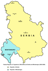
- English: Federal Republic of Yugoslavia (1992-2003) and Serbia and Montenegro (2003-2006).
- Serbian: Savezna Republika Jugoslavija (1992-2003) i Srbija i Crna Gora (2003-2006).
References
- Slobodan Radovanović, Geografski atlas, Magic Map, Smederevska Palanka, 2001.
- Školski geografski atlas, Intersistem Kartografija, Beograd, 2004.
- Miodrag Milošević, Geografija za 8. razred osnovne škole, Beograd, 1994.
- Istorijski atlas, Zavod za kartografiju "Geokarta", Beograd, 1999.
- Denis Šehić - Demir Šehić, Istorijski atlas sveta, Beograd, 2007.
- http://cartage.org.lb/en/themes/GeogHist/geography/cartes/mapcountries/S/photoS/serbia.gif
- http://www.aboutromania.com/SerbiaAndMontenegroMap.gif
- http://cache.virtualtourist.com/1452908-Map_of_Serbia_and_Montenegro-Former_Republic_of_Serbia_and_Montenegro.jpg
- http://www.lib.utexas.edu/maps/europe/serbia.jpg
Source and licence
Self-made map by PANONIAN
| This work has been released into the public domain by its author, PANONIAN. This applies worldwide. Estatu batzuetan beharbada hori ez da legez posible izango. Halakoetan: |

|
This map has been uploaded by Electionworld from en.wikipedia.org to enable the |
Fitxategiaren historia
Data/orduan klik egin fitxategiak orduan zuen itxura ikusteko.
| Data/Ordua | Iruditxoa | Neurriak | Erabiltzailea | Iruzkina | |
|---|---|---|---|---|---|
| oraingoa | 12:27, 25 abuztua 2012 | | 818 × 1.200 (56 KB) | PANONIAN | minor correction |
| 12:12, 25 abuztua 2012 |  | 818 × 1.200 (56 KB) | PANONIAN | minor correction | |
| 14:27, 14 abendua 2009 |  | 818 × 1.200 (56 KB) | PANONIAN | Reverted to version as of 11:32, 14 December 2009 - fixing thumbnail problem | |
| 14:25, 14 abendua 2009 |  | 500 × 669 (95 KB) | PANONIAN | Reverted to version as of 21:41, 21 December 2006 - fixing thumbnail problem | |
| 13:32, 14 abendua 2009 |  | 818 × 1.200 (56 KB) | PANONIAN | improved version | |
| 23:41, 21 abendua 2006 |  | 500 × 669 (95 KB) | Electionworld | {{ew|en|PANONIAN}} Self-made map by PANONIAN {{PD-user|PANONIAN}} Category:Maps of Serbia Category:Maps of Montenegro |
Irudira dakarten loturak
Hurrengo orrialdeek dute fitxategi honetarako lotura:
Fitxategiaren erabilera orokorra
Hurrengo beste wikiek fitxategi hau darabilte:
- als.wikipedia.org proiektuan duen erabilera
- an.wikipedia.org proiektuan duen erabilera
- ar.wikipedia.org proiektuan duen erabilera
- ast.wikipedia.org proiektuan duen erabilera
- az.wikipedia.org proiektuan duen erabilera
- be-tarask.wikipedia.org proiektuan duen erabilera
- be.wikipedia.org proiektuan duen erabilera
- bg.wikipedia.org proiektuan duen erabilera
- bs.wikipedia.org proiektuan duen erabilera
- ca.wikipedia.org proiektuan duen erabilera
- cs.wikipedia.org proiektuan duen erabilera
- cy.wikipedia.org proiektuan duen erabilera
- da.wikipedia.org proiektuan duen erabilera
- el.wikipedia.org proiektuan duen erabilera
- en.wikipedia.org proiektuan duen erabilera
- es.wikipedia.org proiektuan duen erabilera
- fi.wikipedia.org proiektuan duen erabilera
- fr.wikipedia.org proiektuan duen erabilera
- fy.wikipedia.org proiektuan duen erabilera
- gl.wikipedia.org proiektuan duen erabilera
- hi.wikipedia.org proiektuan duen erabilera
- hr.wikipedia.org proiektuan duen erabilera
- id.wikipedia.org proiektuan duen erabilera
- io.wikipedia.org proiektuan duen erabilera
- is.wikipedia.org proiektuan duen erabilera
- it.wikipedia.org proiektuan duen erabilera
- ja.wikipedia.org proiektuan duen erabilera
- kk.wikipedia.org proiektuan duen erabilera
- ko.wikipedia.org proiektuan duen erabilera
- kw.wikipedia.org proiektuan duen erabilera
- li.wikipedia.org proiektuan duen erabilera
- lt.wikipedia.org proiektuan duen erabilera
- lv.wikipedia.org proiektuan duen erabilera
Ikus fitxategi honen erabilpen global gehiago.