
Fitxategi:Trafalgar 1200hr.svg

SVG fitxategi honen PNG aurreikuspenaren tamaina: 606 × 599 pixel. Bestelako bereizmenak: 243 × 240 pixel | 485 × 480 pixel | 776 × 768 pixel | 1.035 × 1.024 pixel | 2.070 × 2.048 pixel | 743 × 735 pixel.
Bereizmen handikoa (SVG fitxategia, nominaldi 743 × 735 pixel, fitxategiaren tamaina: 77 KB)
Fitxategi hau Wikimedia Commonsekoa da. Hango deskribapen orriko informazioa behean duzu. |
Laburpena
| Deskribapena |
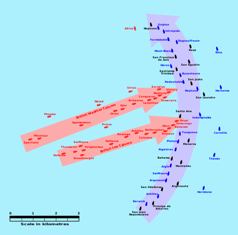
English: This map of the Battle of Trafalgar shows the approximate position of the two fleets at 1200 hours during the battle as the Royal Sovereign was breaking into the Franco-Spanish line. North is to the top, and Cape Trafalgar is 10 miles to the northeast. |
| Data | |
| Jatorria | own work made with Inkscape from Image:Trafalgar 1200hr.gif : This drawing is based on an illustration in issue number 84 of the Strategy & Tactics magazine The map was made by RJHall using the Campaign Cartographer drawing program, and the image was reduced in size 50% in Paint Shop Pro. Ship icons are not to scale. |
| Egilea | Pinpin |
Fitxategi hau (bektore-irudia) hau Inkscape-ekin sortu da .
.
Lizentzia
Nik, lan honen egileak, argitaratzen dut ondorengo lizentzia hauen pean:

|
Baimena duzu dokumentu hau kopiatu, banatu edo/eta aldatzeko GNU Free Documentation License baldintzapean, Free Software Foundationek argitaratutako 1.2 edo ondorengo bertsioan; sekzio aldaezinik gabe, azaleko testurik gabe, eta atzeko azaleko testurik gabe. Lizentziaren kopia dago GNU Free Documentation License izenburudun atalean. |
This file is licensed under the Creative Commons Attribution-Share Alike 3.0 Unported, 2.5 Generic, 2.0 Generic and 1.0 Generic license.
- Askea zara:
- partekatzeko – lana kopiatzeko, banatzeko eta bidaltzeko
- birnahasteko – lana moldatzeko
- Ondorengo baldintzen pean:
- eskuduntza – Egiletza behar bezala aitortu behar duzu, lizentzia ikusteko esteka gehitu, eta ea aldaketak egin diren aipatu. Era egokian egin behar duzu hori guztia, baina inola ere ez egileak zure lana edo zure erabilera babesten duela irudikatuz.
- berdin partekatu – Lan honetan oinarrituta edo aldatuta berria eraikitzen baduzu, emaitza lana hau bezalako lizentzia batekin argitaratu behar duzu.
Nahiago duzun lizentzia erabil dezakezu.
Fitxategiaren historia
Data/orduan klik egin fitxategiak orduan zuen itxura ikusteko.
| Data/Ordua | Iruditxoa | Neurriak | Erabiltzailea | Iruzkina | |
|---|---|---|---|---|---|
| oraingoa | 05:45, 29 urtarrila 2008 | | 743 × 735 (77 KB) | Uhanu | I forgot the colour of Belleisle. |
| 05:43, 29 urtarrila 2008 |  | 743 × 735 (77 KB) | Uhanu | Correcting some names: Montañés , San Ildefonso, Agamemnon, Duguay-Trouin... and colour of Belleisle. | |
| 20:55, 14 abendua 2007 |  | 743 × 735 (77 KB) | Rama | Original SVG version at Image:Trafalgar 1200hr.gif * '''Description:''' This map of the '''Battle of Trafalgar''' shows the approximate position of the two fleets at 1200 hours during the battle as the Royal Sovereign was breaking into the Franc | |
| 22:11, 3 urria 2007 |  | 900 × 850 (73 KB) | Pinpin | I forget one boat | |
| 22:04, 3 urria 2007 |  | 900 × 850 (72 KB) | Pinpin | {{Information |Description={{en|This map of the '''Battle of Trafalgar''' shows the approximate position of the two fleets at 1200 hours during the battle as the Royal Sovereign was breaking into the Franco-Spanish line. North is to the top, and Cape |
Irudira dakarten loturak
Ez dago fitxategi hau darabilen orririk.
Fitxategiaren erabilera orokorra
Hurrengo beste wikiek fitxategi hau darabilte:
- azb.wikipedia.org proiektuan duen erabilera
- bg.wikipedia.org proiektuan duen erabilera
- ca.wikipedia.org proiektuan duen erabilera
- de.wikipedia.org proiektuan duen erabilera
- el.wikipedia.org proiektuan duen erabilera
- en.wikipedia.org proiektuan duen erabilera
- es.wikipedia.org proiektuan duen erabilera
- et.wikipedia.org proiektuan duen erabilera
- fi.wikipedia.org proiektuan duen erabilera
- he.wikipedia.org proiektuan duen erabilera
- hu.wikipedia.org proiektuan duen erabilera
- io.wikipedia.org proiektuan duen erabilera
- it.wikipedia.org proiektuan duen erabilera
- ja.wikipedia.org proiektuan duen erabilera
- nl.wikipedia.org proiektuan duen erabilera
- no.wikipedia.org proiektuan duen erabilera
- ro.wikipedia.org proiektuan duen erabilera
- ru.wikipedia.org proiektuan duen erabilera
- sr.wikipedia.org proiektuan duen erabilera
- sv.wikipedia.org proiektuan duen erabilera
- th.wikipedia.org proiektuan duen erabilera
- vi.wikipedia.org proiektuan duen erabilera
- www.wikidata.org proiektuan duen erabilera