Fitxategi:Wpdms usgs photo sacramento delta 2.jpg

Orriaren edukia ez da onartzen beste hizkuntza batzuetan.
Wikipedia, Entziklopedia askea

Wpdms_usgs_photo_sacramento_delta_2.jpg((700 × 520 pixel, fitxategiaren tamaina: 81 KB, MIME mota: image/jpeg))

Fitxategi hau Wikimedia Commonsekoa da. Hango deskribapen orriko informazioa behean duzu.
Commons gordailu bat da, lizentzia askea duten multimedia fitxategiena. Lagun dezakezu.

Fitxategi hau Wikimedia Commonsekoa da
Deskribapena

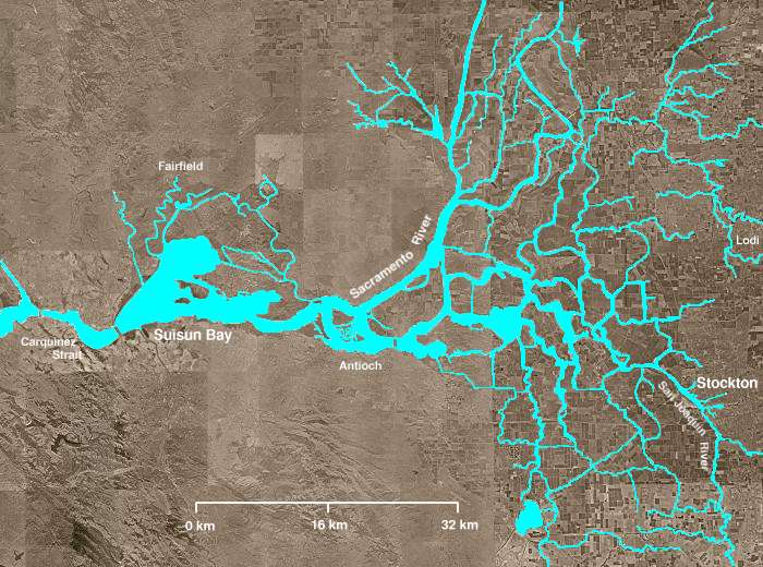
The Sacramento-San Joaquin River Delta of California - covering the right half of the map.

  • The Sacramento River flows into the delta from the north and the San Joaquin River from the south. The San Joaquin and Sacramento rivers meet just west of Antioch and their confluence continues westward into Suisun Bay and then the Carquinez Strait (both on left of map).
  • The Mokelumne River enters from the east, flows northwest from Lodi, picks up several tributaries including the Cosumnes River, then turns south, meandering among several delta sloughs and waterways, ultimately flowing into the San Joaquin River in the center of the delta, northeast of Antioch.
  • The "lake-like" body of water near the bottom of the image is Clifton Court Forebay, where pumps lift water to be sent southward in the California Water Project canal.
  • Several other open areas in the right half of the image are "islands," many of which have elevations well below sea level. Waterways (in blue) are clearly visible, as are fields and croplands (which appear as patchwork), and urban areas (especially Stockton).
Data
Jatorria http://en.wikipedia.org/wiki/Image:Wpdms_usgs_photo_sacramento_delta_2.jpg
Egilea Matthew Trump
Lizentzia
(Fitxategi hau berrerabiltzen)
English Wikipedia user Decumanus, lan honen egileak, argitaratu du edo argitaratzen du ondorengo lizentzia pean:
GNU head Baimena duzu dokumentu hau kopiatu, banatu edo/eta aldatzeko GNU Free Documentation License baldintzapean, Free Software Foundationek argitaratutako 1.2 edo ondorengo bertsioan; sekzio aldaezinik gabe, azaleko testurik gabe, eta atzeko azaleko testurik gabe. Lizentziaren kopia dago GNU Free Documentation License izenburudun atalean.
w:eu:Creative Commons
eskuduntza berdin partekatu
Fitxategi hau Creative Commons Attribution-Share Alike 3.0 Unported lizentziapean dago.
Aitortu: English Wikipedia user Decumanus
Askea zara:
  • partekatzeko – lana kopiatzeko, banatzeko eta bidaltzeko
  • birnahasteko – lana moldatzeko
Ondorengo baldintzen pean:
  • eskuduntza – Egiletza behar bezala aitortu behar duzu, lizentzia ikusteko esteka gehitu, eta ea aldaketak egin diren aipatu. Era egokian egin behar duzu hori guztia, baina inola ere ez egileak zure lana edo zure erabilera babesten duela irudikatuz.
  • berdin partekatu – Lan honetan oinarrituta edo aldatuta berria eraikitzen baduzu, emaitza lana hau bezalako lizentzia batekin argitaratu behar duzu.
This licensing tag was added to this file as part of the GFDL licensing update.
Beste bertsioak Derivative works of this file:  California Grizzly Bear walking in the Delta Region.jpg

en:Sacramento-San Joaquin River Delta

Irudi-oineko testuak

Add a one-line explanation of what this file represents
The Sacramento-San Joaquin River Delta of California

Fitxategi honetan agertzen diren itemak

honako hau irudikatzen du

Fitxategiaren historia

Data/orduan klik egin fitxategiak orduan zuen itxura ikusteko.

Data/OrduaIruditxoaNeurriakErabiltzaileaIruzkina
oraingoa05:21, 8 abuztua 200805:21, 8 abuztua 2008 bertsioaren iruditxoa700 × 520 (81 KB)Captndelta{{Information |Description=The Sacramento-San Joaquin River Delta covers the right half of this image. The Sacramento River flows into the delta from the north and the San Joaquin River from the south. The Mokelumne River

Hurrengo orrialdeek dute fitxategi honetarako lotura:

Fitxategiaren erabilera orokorra

Hurrengo beste wikiek fitxategi hau darabilte:

Metadatuak