
Fitxategi:Agricultural Fields near Perdizes, Minas Gerais, Brazil.JPG

Aurreikuspen honen neurria: 800 × 532 pixel. Bestelako bereizmenak: 320 × 213 pixel | 640 × 425 pixel | 1.024 × 681 pixel | 1.280 × 851 pixel | 2.560 × 1.701 pixel | 4.288 × 2.850 pixel.
Bereizmen handikoa ((4.288 × 2.850 pixel, fitxategiaren tamaina: 2,83 MB, MIME mota: image/jpeg))
Fitxategi hau Wikimedia Commonsekoa da. Hango deskribapen orriko informazioa behean duzu. |
Laburpena
| Deskribapena |
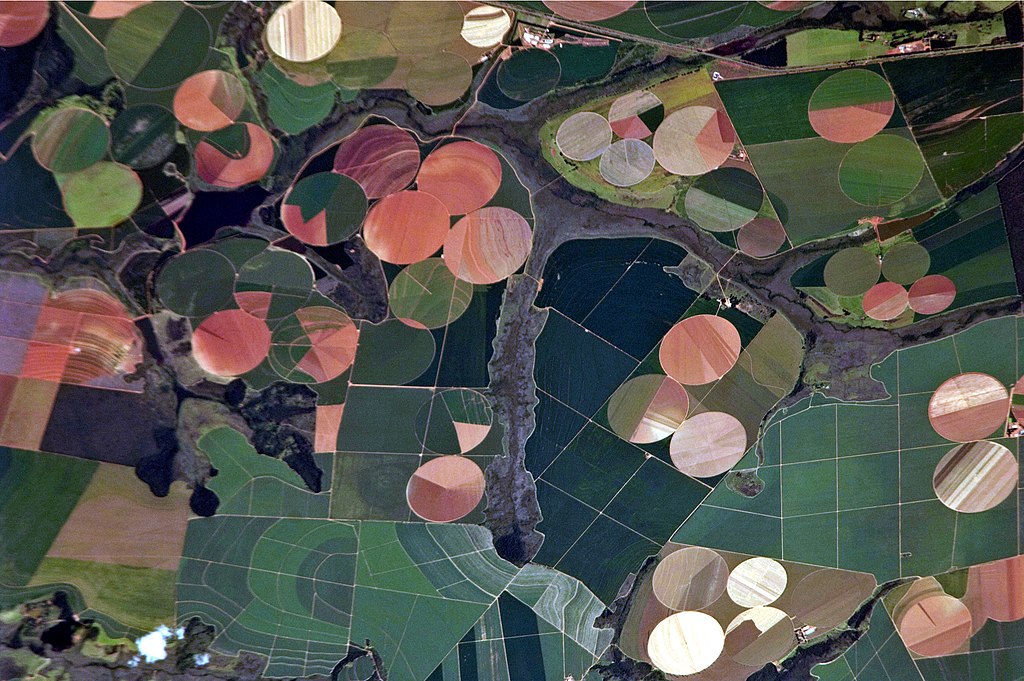
English: This astronaut photograph illustrates the diverse agricultural landscape in the western part of Minas Gerais state in Brazil. The fields in this image are located south-west of the city of Perdizes, which means “partridges” in Portuguese. A mix of regularly-gridded polygonal fields and circular centre-pivot fields marks the human use of the region. Small streams (and their adjacent floodplains) of the Araguari River extend like fingers throughout the landscape. – The visual diversity of the field forms is matched by the variety of crops: sunflowers, wheat, potatoes, coffee, rice, soybeans, and corn are among the products of the region. While the Northern Hemisphere is still in the grip of winter, crops are growing in the Southern Hemisphere, as indicated by the many green fields. Fallow fields—not in active agricultural use—display the violet, reddish, and light tan soils common to this part of Brazil. Darker soils are often rich in iron and aluminum oxides, and are typical of highly weathered soil that forms in hot, humid climates. |
| Data | |
| Jatorria |
English: NASA Earth Observatory – Image acquired with a Nikon D2Xs digital camera using an 800 mm lens, and is provided by the ISS Crew Earth Observations experiment and Image Science & Analysis Laboratory, Johnson Space Center. |
| Egilea | ISS Expedition 26 crew |
| Kameraren kokapena | | Irudi hau eta gehiago beraien kokapenekin hurrengo lekuetan: OpenStreetMap |
|---|
This image or video was catalogued by Johnson Space Center of the United States National Aeronautics and Space Administration (NASA) under Photo ID: ISS026-E-25373. This tag does not indicate the copyright status of the attached work. A normal copyright tag is still required. See Commons:Licensing. Other languages:
|
Lizentzia
This file is in the public domain in the United States because it was created by the Image Science & Analysis Laboratory, of the NASA Johnson Space Center. NASA copyright policy states that "NASA material is not protected by copyright unless noted". (NASA media use guidelines or Conditions of Use of Astronaut Photographs).
Photo source: ISS026-E-25373.
|
| Annotations | This image is annotated: View the annotations at Commons |
Fitxategiaren historia
Data/orduan klik egin fitxategiak orduan zuen itxura ikusteko.
| Data/Ordua | Iruditxoa | Neurriak | Erabiltzailea | Iruzkina | |
|---|---|---|---|---|---|
| oraingoa | 19:46, 15 abendua 2014 | | 4.288 × 2.850 (2,83 MB) | ArionStar | Reverted to version as of 12:59, 21 February 2011 |
| 16:38, 10 abendua 2014 |  | 2.629 × 1.994 (1,1 MB) | ArionStar | Lower resolution but better quality | |
| 16:30, 10 abendua 2014 |  | 2.616 × 2.028 (1,14 MB) | ArionStar | Lower resolution but better quality | |
| 14:59, 21 otsaila 2011 |  | 4.288 × 2.850 (2,83 MB) | Originalwana | {{Information |Description ={{en|1=This astronaut photograph illustrates the diverse agricultural landscape in the western part of Minas Gerais state in Brazil. The fields in this image are located south-west of the city of [[:Category:Perdizes|Perdize |
Irudira dakarten loturak
Hurrengo orrialdeek dute fitxategi honetarako lotura:
Fitxategiaren erabilera orokorra
Hurrengo beste wikiek fitxategi hau darabilte:
- bg.wikipedia.org proiektuan duen erabilera
- el.wikipedia.org proiektuan duen erabilera
- en.wikipedia.org proiektuan duen erabilera
- fr.wikipedia.org proiektuan duen erabilera
- nl.wikipedia.org proiektuan duen erabilera
- pt.wikipedia.org proiektuan duen erabilera