
Fitxategi:Mauna Loa map.gif

Aurreikuspen honen neurria: 560 × 600 pixel. Bestelako bereizmenak: 224 × 240 pixel | 448 × 480 pixel | 717 × 768 pixel | 1.124 × 1.204 pixel.
Bereizmen handikoa ((1.124 × 1.204 pixel, fitxategiaren tamaina: 26 KB, MIME mota: image/gif), 0,1s)
Fitxategi hau Wikimedia Commonsekoa da. Hango deskribapen orriko informazioa behean duzu. |
Laburpena
| Deskribapena |
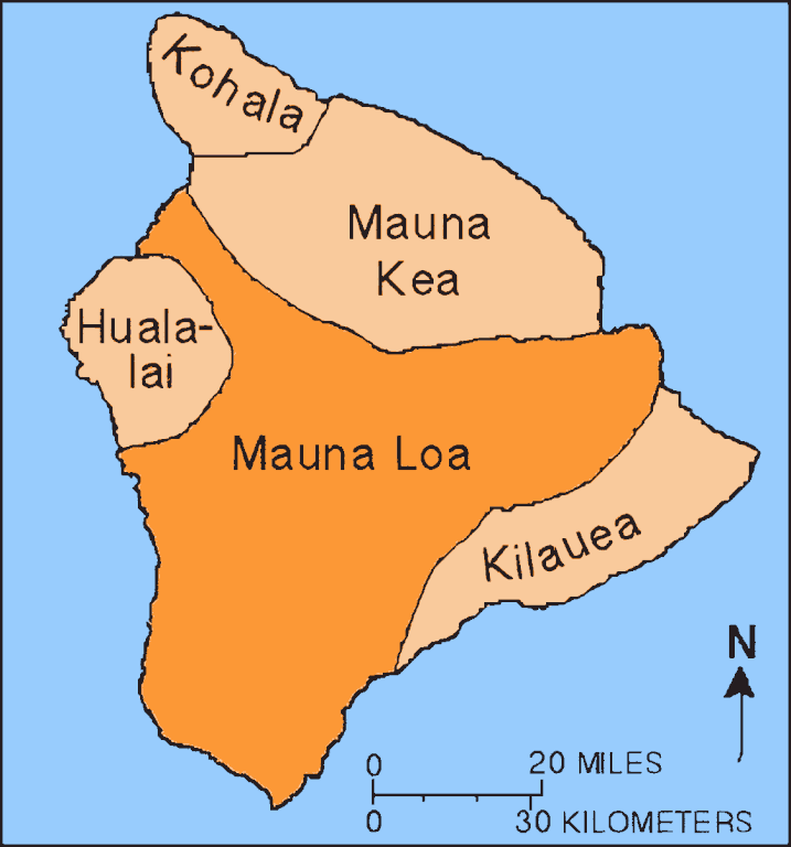
English: Map showing relationship of Mauna Loa to other volcanoes that form the Big Island of Hawaii |
| Data | (UTC) |
| Jatorria |
Fitxategi hau hemendik eratorria izan da: Mapmaunaloa.png:  |
| Egilea |
|
Lizentzia
This image is in the public domain in the United States because it only contains materials that originally came from the United States Geological Survey, an agency of the United States Department of the Interior. For more information, see the official USGS copyright policy.
|
AI upscaling:
| This file is made available under the Creative Commons CC0 1.0 Universal Public Domain Dedication. | |
| The person who associated a work with this deed has dedicated the work to the public domain by waiving all of their rights to the work worldwide under copyright law, including all related and neighboring rights, to the extent allowed by law. You can copy, modify, distribute and perform the work, even for commercial purposes, all without asking permission.
|
Jatorrizko igoera erregistroa
This image is a derivative work of the following images:
- File:Mapmaunaloa.png licensed with PD-USGov-USGS
- 2010-06-24T12:52:47Z Ras67 279x299 (3732 Bytes) cropped and squeezed
- 2009-07-13T06:34:04Z Falcorian 281x301 (8369 Bytes) Lossless compression with pngout.
- 2007-08-05T14:58:34Z Hike395 281x301 (9579 Bytes) {{Information |Description={{en|Map showing relationship of Mauna Loa to other volcanoes that form the Big Island of Hawaii} |Source=http://hvo.wr.usgs.gov/maunaloa/ |Date=- |Author=Hawaii Volcano Observatory, USGS |Permissio
Uploaded with derivativeFX
Fitxategiaren historia
Data/orduan klik egin fitxategiak orduan zuen itxura ikusteko.
| Data/Ordua | Iruditxoa | Neurriak | Erabiltzailea | Iruzkina | |
|---|---|---|---|---|---|
| oraingoa | 17:14, 21 iraila 2023 | | 1.124 × 1.204 (26 KB) | Hike395 | == {{int:filedesc}} == {{Information |Description={{en|Map showing relationship of Mauna Loa to other volcanoes that form the Big Island of Hawaii}} |Source={{Derived from|Mapmaunaloa.png|display=50}} |Date=2023-09-21 15:13 (UTC) |Author=* File:Mapmaunaloa.png: Hawaii Volcano Observatory, USGS * AI upscaling: [[User:{{subst:REVISIONUSER}}|{{subst:REVISIONUSER}}]] |Permission= |other_versions= }} == {{int:license-header}} == {{PD-USGo... |
Irudira dakarten loturak
Hurrengo orrialdeek dute fitxategi honetarako lotura:
Fitxategiaren erabilera orokorra
Hurrengo beste wikiek fitxategi hau darabilte: