
Fitxategi:Tornado Alley.gif
Ez dago bereizmen handiagorik.
Tornado_Alley.gif ((742 × 582 pixel, fitxategiaren tamaina: 97 KB, MIME mota: image/gif))
Fitxategi hau Wikimedia Commonsekoa da. Hango deskribapen orriko informazioa behean duzu. |

|
File:Tornado Alley.svg fitxategi honen bektore bertsioa da. Hau rasterizatutako bertsioaren ordez erabili beharko litzateke hobea izatekotan.
File:Tornado Alley.gif → File:Tornado Alley.svg
Grafiko bektorialei buruzko informazioa lortzeko, irakurri SVGra trantsizioa Commonsen. MediaWikiko SVG irudien inguruko laguntza teknikoa ere badago. |
 |
Laburpena
| Deskribapena |
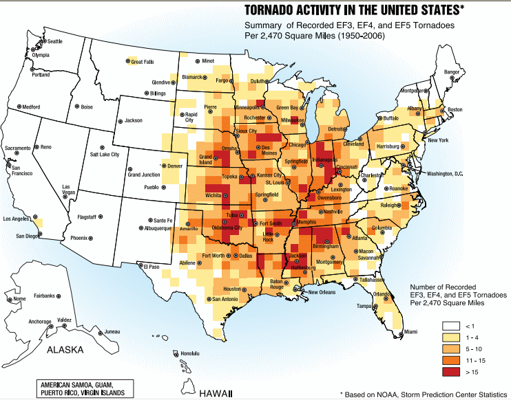
English: A map of the frequency of F3 and greater intensity tornadoes by area. The darker colors highlight the areas typically known as a Tornado Alley. |
| Data | |
| Jatorria | Image from Federal Emergency Management Agency, a United States government agency, booklet FEMA 320 Third Edition, Section 1, Figure 1.1, page 3, titled Taking Shelter from the Storm: Building a Safe Room Inside your House |
| Egilea | FEMA personnel |
Lizentzia
This image is a work of a Federal Emergency Management Agency employee, taken or made as part of that person's official duties. As works of the U.S. federal government, all FEMA images are in the public domain in the United States. Additional media usage information may be found at https://www.fema.gov/photo-video-audio-use-guidelines
|
Fitxategiaren historia
Data/orduan klik egin fitxategiak orduan zuen itxura ikusteko.
| Data/Ordua | Iruditxoa | Neurriak | Erabiltzailea | Iruzkina | |
|---|---|---|---|---|---|
| oraingoa | 19:25, 2 urria 2013 | | 742 × 582 (97 KB) | Nodove | Greater city name resolution. |
| 19:13, 4 otsaila 2007 |  | 550 × 406 (67 KB) | TCY | A map of the frequency of F3 and greater intensity tornadoes by area. The darker colors highlight the area typically known as Tornado Alley. '''Source:''' Image from a booklet from [http://www.fema.gov/index.shtm |
Irudira dakarten loturak
Hurrengo orrialdeek dute fitxategi honetarako lotura:
Fitxategiaren erabilera orokorra
Hurrengo beste wikiek fitxategi hau darabilte:
- af.wikipedia.org proiektuan duen erabilera
- ast.wikipedia.org proiektuan duen erabilera
- ba.wikipedia.org proiektuan duen erabilera
- ca.wikipedia.org proiektuan duen erabilera
- de.wikipedia.org proiektuan duen erabilera
- en.wikipedia.org proiektuan duen erabilera
- en.wikibooks.org proiektuan duen erabilera
- es.wikipedia.org proiektuan duen erabilera
- fa.wikipedia.org proiektuan duen erabilera
- fr.wikipedia.org proiektuan duen erabilera
- gl.wikipedia.org proiektuan duen erabilera
- he.wikivoyage.org proiektuan duen erabilera
- hu.wikipedia.org proiektuan duen erabilera
- it.wikipedia.org proiektuan duen erabilera
- ja.wikipedia.org proiektuan duen erabilera
- lt.wikipedia.org proiektuan duen erabilera
- nl.wikipedia.org proiektuan duen erabilera
- pl.wikipedia.org proiektuan duen erabilera
- pt.wikipedia.org proiektuan duen erabilera
- ru.wikipedia.org proiektuan duen erabilera
- simple.wikipedia.org proiektuan duen erabilera
- sl.wikipedia.org proiektuan duen erabilera
- sv.wikipedia.org proiektuan duen erabilera
- uk.wikipedia.org proiektuan duen erabilera
- zh.wikipedia.org proiektuan duen erabilera