
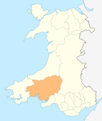
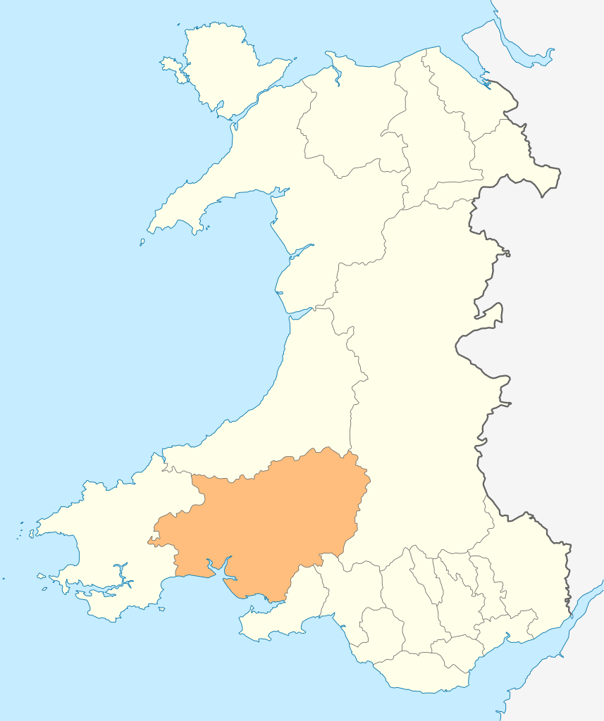
Fitxategi:Wales Carmarthenshire locator map.svg

SVG fitxategi honen PNG aurreikuspenaren tamaina: 502 × 600 pixel. Bestelako bereizmenak: 201 × 240 pixel | 402 × 480 pixel | 643 × 768 pixel | 857 × 1.024 pixel | 1.714 × 2.048 pixel | 1.047 × 1.251 pixel.
Bereizmen handikoa (SVG fitxategia, nominaldi 1.047 × 1.251 pixel, fitxategiaren tamaina: 151 KB)
Fitxategi hau Wikimedia Commonsekoa da. Hango deskribapen orriko informazioa behean duzu. |
Laburpena
| Deskribapena |
Deutsch: Lagekarte von Carmarthenshire in Wales
English: Locator map of Carmarthenshire in Wales |
| Data | |
| Jatorria | Norberak egina |
| Egilea | NordNordWest |
| Lizentzia (Fitxategi hau berrerabiltzen) |
Nik, lan honen egileak, argitaratzen dut ondorengo lizentzia pean: Fitxategi hau Creative Commons Attribution-Share Alike 3.0 Unported lizentziapean dago.
|

|
This map has been made or improved in the German Kartenwerkstatt (Map Lab). You can propose maps to improve as well.
|
Fitxategiaren historia
Data/orduan klik egin fitxategiak orduan zuen itxura ikusteko.
| Data/Ordua | Iruditxoa | Neurriak | Erabiltzailea | Iruzkina | |
|---|---|---|---|---|---|
| oraingoa | 20:49, 4 maiatza 2010 | | 1.047 × 1.251 (151 KB) | NordNordWest | {{int:filedesc}} {{Information |Description= {{de|Lagekarte von Carmarthenshire in Wales}} {{en|Locator map of Carmarthenshire in Wales}} |Source={{Own}} |Date=2010-05-04 |Author={{U|NordNordWest}} |Permission={{self|cc-by-sa-3.0}} |other_versions= }} {{ |
Irudira dakarten loturak
100 orrik baino gehiagok darabilte fitxategi hau. Ondorengo zerrendan, fitxategi hau darabilten lehen 100 orriak besterik ez da ageri. Ikusgai duzu zerrenda osoa ere.
- Abergwili
- Abernant (Carmarthenshire)
- Alltwalis
- Ammanford
- Bethlehem (Carmarthenshire)
- Betws (Carmarthenshire)
- Bronwydd
- Bryn (Llanelli)
- Brynamman
- Burry Port
- Bynea
- Capel Gwynfe
- Carmarthen
- Carway
- Cenarth
- Cilycwm
- Cilymaenllwyd
- Cwmamman
- Cwmgwili
- Cynwyl Elfed
- Cynwyl Gaeo
- Dafen (Carmarthenshire)
- Dolgran
- Dyffryn Cennen
- Eglwyscummin
- Felinfoel
- Five Roads
- Gorslas
- Gwyddgrug
- Hendy
- Henllan Amgoed
- Henllanfallteg
- Kidwelly
- Laugharne
- Laugharne Township
- Llanarthney
- Llanboidy
- Llanddarog
- Llanddeusant (Carmarthenshire)
- Llanddowror
- Llandeilo
- Llandovery
- Llandybie
- Llandyfaelog
- Llanedi
- Llanegwad
- Llanelli
- Llanelli Rural
- Llanfair-ar-y-bryn
- Llanfihangel-ar-Arth
- Llanfihangel Aberbythych
- Llanfihangel Rhos-y-Corn
- Llanfynydd
- Llangadog
- Llangain
- Llangathen
- Llangeler
- Llangennech
- Llangunnor
- Llangyndeyrn
- Llangynin
- Llangynog (Carmarthenshire)
- Llanllawddog
- Llanllwni
- Llannon
- Llanpumsaint
- Llansadwrn
- Llansawel
- Llansteffan
- Llanwinio
- Llanwrda
- Llanybydder
- Llanycrwys
- Llwynhendy
- Manordeilo and Salem
- Meidrim
- Myddfai
- New Inn (Carmarthenshire)
- Newcastle Emlyn
- Newchurch and Merthyr
- Pemberton (Carmarthenshire)
- Pembrey and Burry Port Town
- Pen-y-groes (Carmarthenshire)
- Pencader (Carmarthenshire)
- Pencarreg
- Penceiliogi
- Pendine
- Pont-henri
- Pontyberem
- Pwll
- Quarter Bach
- Red Roses
- Saron (Carmarthenshire)
- St Clears
- St Ishmael (Carmarthenshire)
- Talley
- Trelech
- Tumble (Carmarthenshire)
- Tycroes
- Whitland
Ikusi fitxategi honen lotura gehiago.
Fitxategiaren erabilera orokorra
Hurrengo beste wikiek fitxategi hau darabilte:
- cs.wikipedia.org proiektuan duen erabilera
- de.wikipedia.org proiektuan duen erabilera
- en.wikipedia.org proiektuan duen erabilera
- WWT Llanelli Wetlands Centre
- Carmarthenshire
- Sandy, Carmarthenshire
- Llanelli
- Carmarthen
- Llandeilo
- Newcastle Emlyn
- Whitland
- Burry Port
- Kidwelly
- Llandovery
- Laugharne
- St Clears
- Pendine
- Garreg Lwyd (Black Mountain)
- Llandybie
- Llanwrda
- Afon Cothi
- Cwmann
- Bancyfelin
- Talley
- Aber-arad
- Aber-giar
- Abergorlech
- Abernant, Carmarthenshire
- Cross Hands
- Pantyffynnon
- List of places in Carmarthenshire
- Brandy Hill, Wales
- Caio, Carmarthenshire
- Template:Carmarthenshire-geo-stub
- Bryn, Llanelli
- Pemberton, Carmarthenshire
- Dafen, Carmarthenshire
- Pendine Museum of Speed
- Usk Reservoir
- River Cywyn
- Five Roads
- Maesybont
- Glanymor
- Trefawr Track
- Bethlehem, Carmarthenshire
- Stradey
- Cross Inn
- Bronwydd
- Llanfihangel Rhos-y-Corn
- St Ishmael, Carmarthenshire
- Elvet Hundred
Ikus fitxategi honen erabilpen global gehiago.