
Fitxategi:World map 1815 (COV).jpg

Bereizmen handikoa ((4.000 × 2.304 pixel, fitxategiaren tamaina: 1,49 MB, MIME mota: image/jpeg))
Fitxategi hau Wikimedia Commonsekoa da. Hango deskribapen orriko informazioa behean duzu. |
.jpg)
Laburpena
| Deskribapena |
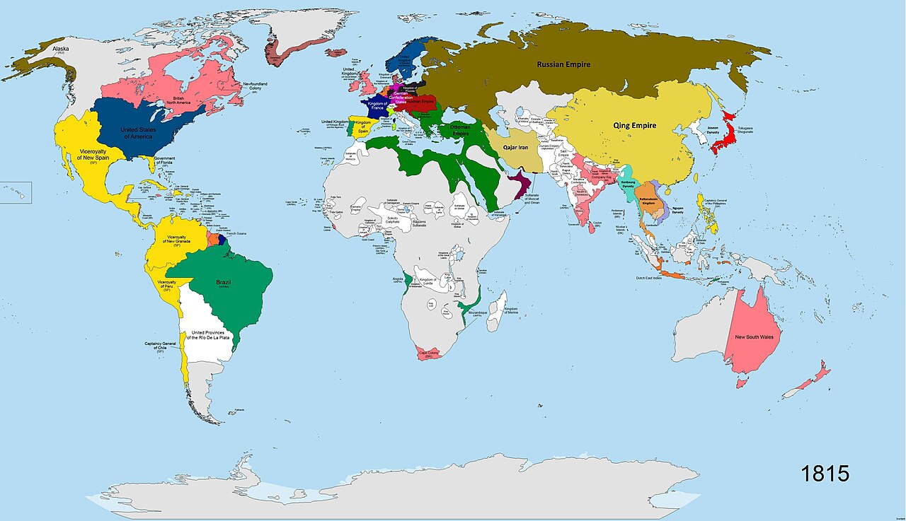
English: A map of the world in the year 1815 AD. States shown in colours:
Britain (pink), France (navy blue), Sweden (dark blue), Prussia (dark grey), the states of the German Confederation (pink), Austria (burgundy), Spain (yellow), Portugal (green-turquoise), Ottoman Empire (dark green), Iran (light green), Russia (brown), Netherlands (orange), Sardinia/Savoy (lime green), China (cream-yellow), Japan (bright red), Denmark (dull red), Oman (maroon-purple), USA (dark blue, similar to Sweden). All other states shown in white. Terra Nullis shown in grey. |
| Data | |
| Jatorria | Norberak egina |
| Egilea | SvoHljott |
Map covers entire globe. Research for accuracy took 5 months. Borders are as accurate as possible, where no maps of the individual states at the time existed, borders are based on rivers and cities.
| Maps of world history | |
| BC | |
|
| |
| AD |
1 · 50 · 100 · 200 · 250 · 300 · 400 · 500 · 700 · 750 · 820 · 900 · 1200 · 1500 · 1556 · 1648 · 1700 · 1750 · 1815 · 1859 · 1871 · 1914 · 1935 · 1954 · 1989 · 2000 · |
|
Maps of colonization history | |
|
see also: Eastern Hemisphere only maps template (1300BC-1500AD) | |
| (this template: · view · discuss ) | |
._LOC_2001620596.jpg)
Lizentzia
- Askea zara:
- partekatzeko – lana kopiatzeko, banatzeko eta bidaltzeko
- birnahasteko – lana moldatzeko
- Ondorengo baldintzen pean:
- eskuduntza – Egiletza behar bezala aitortu behar duzu, lizentzia ikusteko esteka gehitu, eta ea aldaketak egin diren aipatu. Era egokian egin behar duzu hori guztia, baina inola ere ez egileak zure lana edo zure erabilera babesten duela irudikatuz.
- berdin partekatu – Lan honetan oinarrituta edo aldatuta berria eraikitzen baduzu, emaitza lana hau bezalako lizentzia batekin argitaratu behar duzu.
Fitxategiaren historia
Data/orduan klik egin fitxategiak orduan zuen itxura ikusteko.
| Data/Ordua | Iruditxoa | Neurriak | Erabiltzailea | Iruzkina | |
|---|---|---|---|---|---|
| oraingoa | 14:32, 28 martxoa 2023 | | 4.000 × 2.304 (1,49 MB) | Yourlocallordandsavior | Minor tweaks. |
| 14:18, 28 martxoa 2023 |  | 4.000 × 2.304 (1,5 MB) | Yourlocallordandsavior | Improved Mainland SE Asia's borders. | |
| 10:43, 19 martxoa 2023 |  | 4.000 × 2.304 (896 KB) | Achim55 | Reverted to version as of 17:26, 3 October 2020 (UTC) | |
| 08:15, 18 martxoa 2023 |  | 4.500 × 2.592 (2,51 MB) | Dndnrmn1 | Reverted to version as of 17:57, 1 May 2014 (UTC) | |
| 19:26, 3 urria 2020 |  | 4.000 × 2.304 (896 KB) | Ориенталист | minor coppections | |
| 19:57, 1 maiatza 2014 |  | 4.500 × 2.592 (2,51 MB) | SvoHljott | Added Company Raj label. | |
| 16:33, 1 maiatza 2014 |  | 4.500 × 2.592 (2,5 MB) | SvoHljott | Added labels for Cape Verde, the Falklands, the Guianas and Goa. | |
| 14:45, 1 maiatza 2014 |  | 4.500 × 2.592 (1,45 MB) | SvoHljott | Added Sao Tome and Principe, Bioko and the African Great Lake States labels. | |
| 14:15, 1 maiatza 2014 |  | 4.500 × 2.592 (1,45 MB) | SvoHljott | User created page with UploadWizard |
Irudira dakarten loturak
Hurrengo orrialdeek dute fitxategi honetarako lotura:
Fitxategiaren erabilera orokorra
Hurrengo beste wikiek fitxategi hau darabilte:
- de.wikipedia.org proiektuan duen erabilera
- en.wikipedia.org proiektuan duen erabilera
- es.wikipedia.org proiektuan duen erabilera
- lv.wikipedia.org proiektuan duen erabilera
- nl.wikipedia.org proiektuan duen erabilera
- pap.wikipedia.org proiektuan duen erabilera
- sr.wikipedia.org proiektuan duen erabilera
.jpg)