
Fitxategi:Babilonia de Hammurabi-ES.svg

SVG fitxategi honen PNG aurreikuspenaren tamaina: 687 × 599 pixel. Bestelako bereizmenak: 275 × 240 pixel | 550 × 480 pixel | 880 × 768 pixel | 1.174 × 1.024 pixel | 2.348 × 2.048 pixel | 705 × 615 pixel.
Bereizmen handikoa (SVG fitxategia, nominaldi 705 × 615 pixel, fitxategiaren tamaina: 304 KB)
Fitxategi hau Wikimedia Commonsekoa da. Hango deskribapen orriko informazioa behean duzu. |
Laburpena
| Deskribapena |
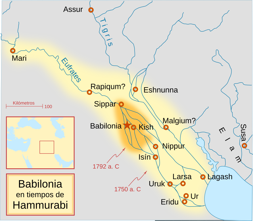
English: A locator map of Hammurabi's Babylonia, showing the Babylonian territory upon his ascension in 1792 BC and upon his death in 1750 BC. The river courses and coastline are those of that time period -- in general, they are not the modern rivers or coastlines. This is a Mercator projection, with north in its usual position.
There is some question to what degree the cities of Nineveh, Tuttul, and Assur were under Babylonian authority. While in his introduction to his code of laws, Hammurabi claims lordship over these cities, Roaf does not include any of these in his map, upon which this map is based, and Chevalas states that "Assur and Nineveh were held for a very few years" (p. 155). Therefore, I have not included them as under Hammurabi's control in 1750 BC.
Español: Mapa de la Babilonia de Hammurabi, mostrando el territorio entre su ascenso en 1792 a. C. y su muerte en 1750 a. C. La linea de costa y los cursos de los ríos son los de ese período. El norte se encuentra en su posición usual.
Existen algunas dudas sobre si las ciudades de Nínive, Tttul y Asur estuvieron bajo la autoridad babilona. Mientras que en la introducción del "código de Hammurabi" se asegura su posesión, Roaf no incluye ninguna de ellas, en cuyo mapa está basado éste. |
| Data | |
| Jatorria | Translation of File:Hammurabi's Babylonia 1.svg |
| Egilea | Crates |
| Beste bertsioak |
[]
|


Lizentzia
Nik, lan honen egileak, argitaratzen dut ondorengo lizentzia hauen pean:

|
Baimena duzu dokumentu hau kopiatu, banatu edo/eta aldatzeko GNU Free Documentation License baldintzapean, Free Software Foundationek argitaratutako 1.2 edo ondorengo bertsioan; sekzio aldaezinik gabe, azaleko testurik gabe, eta atzeko azaleko testurik gabe. Lizentziaren kopia dago GNU Free Documentation License izenburudun atalean. |
This file is licensed under the Creative Commons Attribution-Share Alike Attribution-Share Alike 4.0 International, 3.0 Unported, 2.5 Generic, 2.0 Generic and 1.0 Generic license.
- Askea zara:
- partekatzeko – lana kopiatzeko, banatzeko eta bidaltzeko
- birnahasteko – lana moldatzeko
- Ondorengo baldintzen pean:
- eskuduntza – Egiletza behar bezala aitortu behar duzu, lizentzia ikusteko esteka gehitu, eta ea aldaketak egin diren aipatu. Era egokian egin behar duzu hori guztia, baina inola ere ez egileak zure lana edo zure erabilera babesten duela irudikatuz.
- berdin partekatu – Lan honetan oinarrituta edo aldatuta berria eraikitzen baduzu, emaitza lana hau bezalako lizentzia batekin argitaratu behar duzu.
Nahiago duzun lizentzia erabil dezakezu.
Fitxategiaren historia
Data/orduan klik egin fitxategiak orduan zuen itxura ikusteko.
| Data/Ordua | Iruditxoa | Neurriak | Erabiltzailea | Iruzkina | |
|---|---|---|---|---|---|
| oraingoa | 11:48, 12 martxoa 2017 | | 705 × 615 (304 KB) | Rowanwindwhistler | Fake text added. Colours from https://en.wikipedia.org/wiki/Wikipedia:WikiProject_Maps/Conventions http://colorbrewer2.org/#type=sequential&scheme=YlOrBr&n=3 |
| 22:28, 17 urtarrila 2009 |  | 661 × 577 (159 KB) | Phirosiberia | {{Information |Description={{en|1=A locator map of Hammurabi's Babylonia, showing the Babylonian territory upon his ascension in 1792 BC and upon his death in 1750 BC. The river courses and coastline are those of that time period -- in general, they are n |
Irudira dakarten loturak
Hurrengo orrialdeek dute fitxategi honetarako lotura:
Fitxategiaren erabilera orokorra
Hurrengo beste wikiek fitxategi hau darabilte:
- ca.wikipedia.org proiektuan duen erabilera
- es.wikipedia.org proiektuan duen erabilera
- lv.wikipedia.org proiektuan duen erabilera
- pt.wikipedia.org proiektuan duen erabilera