
Fitxategi:SafsafOasis SAR comparison.jpg
Ez dago bereizmen handiagorik.
SafsafOasis_SAR_comparison.jpg ((540 × 588 pixel, fitxategiaren tamaina: 154 KB, MIME mota: image/jpeg))
Fitxategi hau Wikimedia Commonsekoa da. Hango deskribapen orriko informazioa behean duzu. |
Laburpena
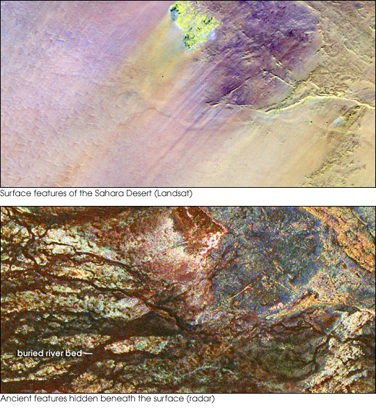
| Deskribapena | Two images of the Safsaf Oasis in The Sahara. The top image (taken by the Landat Thematic Mapper) is the surface. The bottom (taken by the Spaceborne Imaging Radar-C/X-band Synthetic Aperture Radar (SIR-C/X-SAR) on board the Space Shuttle Endeavour on April 16, 1994) is the rock layer underneath, revealing black channels cut by the meandering of an ancient river. |
| Data | not specified |
| Jatorria | http://earthobservatory.nasa.gov/Newsroom/NewImages/images.php3?img_id=16963 |
| Egilea | NASA/JPL Imaging Radar team. |
| Lizentzia (Fitxategi hau berrerabiltzen) |
Public domain |
| Beste bertsioak |
|


Lizentzia
| This file is in the public domain in the United States because it was solely created by NASA. NASA copyright policy states that "NASA material is not protected by copyright unless noted". (See Template:PD-USGov, NASA copyright policy page or JPL Image Use Policy.) | ||
 |
Warnings:
|
Fitxategiaren historia
Data/orduan klik egin fitxategiak orduan zuen itxura ikusteko.
| Data/Ordua | Iruditxoa | Neurriak | Erabiltzailea | Iruzkina | |
|---|---|---|---|---|---|
| oraingoa | 17:55, 9 maiatza 2006 | | 540 × 588 (154 KB) | Holly Cheng | {{Information | Description=Two images of the Safsaf Oasis in the Sahara. The top image (taken by the Landat Thematic Mapper) is the surface. The bottom (taken by the Spaceborne Imaging Radar-C/X-band Synthetic Aperture Radar (SIR-C/X-SAR) on board the Sp |
Irudira dakarten loturak
Hurrengo orrialdeek dute fitxategi honetarako lotura:
Fitxategiaren erabilera orokorra
Hurrengo beste wikiek fitxategi hau darabilte:
- es.wikipedia.org proiektuan duen erabilera
- la.wikipedia.org proiektuan duen erabilera
- nds-nl.wikipedia.org proiektuan duen erabilera
- rw.wikipedia.org proiektuan duen erabilera
- sw.wikipedia.org proiektuan duen erabilera
- vi.wikipedia.org proiektuan duen erabilera
- zh-yue.wikipedia.org proiektuan duen erabilera