
Fitxategi:Torpedoed Japanese destroyer Yamakaze sinking on 25 June 1942.jpg

Aurreikuspen honen neurria: 759 × 599 pixel. Bestelako bereizmenak: 304 × 240 pixel | 608 × 480 pixel | 973 × 768 pixel | 1.280 × 1.011 pixel | 2.560 × 2.021 pixel | 2.937 × 2.319 pixel.
Bereizmen handikoa ((2.937 × 2.319 pixel, fitxategiaren tamaina: 3,84 MB, MIME mota: image/jpeg))
Fitxategi hau Wikimedia Commonsekoa da. Hango deskribapen orriko informazioa behean duzu. |
Laburpena
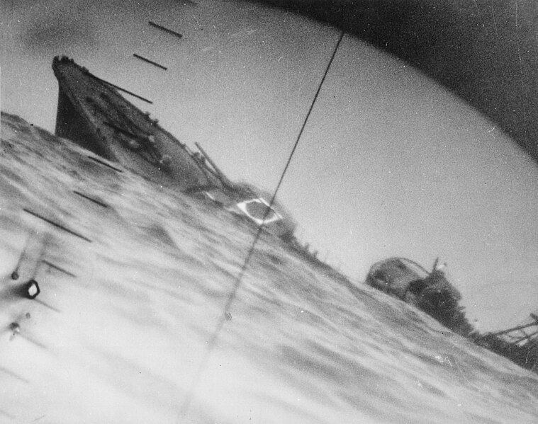
| Deskribapena | Sinking of the Japanese destroyer Yamakaze on 25 June 1942 approximately 110 km southeast of Yokosuku, Japan, photographed through the periscope of the U.S. Navy submarine USS Nautilus (SS-168). This position is given in The Official Chronology of the U.S. Navy in World War II by Robert Cressman. NH 111751 says 75 miles southwest of Yokahama Harbor. Yokahama is near Yokosuku. | |||
| Data | ||||
| Jatorria |
|
|||
| Egilea | U.S. Navy | |||
| Beste bertsioak | Official U.S. Navy photo NH 111751 from the U.S. Navy Naval History and Heritage Command |
| Kameraren kokapena | | Irudi hau eta gehiago beraien kokapenekin hurrengo lekuetan: OpenStreetMap |
|---|
|
Lizentzia
This file is a work of a sailor or employee of the U.S. Navy, taken or made as part of that person's official duties. As a work of the U.S. federal government, it is in the public domain in the United States.
|
 | |
| This file has been identified as being free of known restrictions under copyright law, including all related and neighboring rights. | ||
Fitxategiaren historia
Data/orduan klik egin fitxategiak orduan zuen itxura ikusteko.
| Data/Ordua | Iruditxoa | Neurriak | Erabiltzailea | Iruzkina | |
|---|---|---|---|---|---|
| oraingoa | 08:37, 9 urria 2016 | | 2.937 × 2.319 (3,84 MB) | Cobatfor | new NHHC file |
| 22:55, 21 abuztua 2007 |  | 2.985 × 2.048 (1,5 MB) | BrokenSphere | == Summary == {{Information |Description=Torpedoed Japanese destroyer photographed through periscope of U.S.S. Wahoo or U.S.S. Nautilus, June 1942. (Navy) Exact Date Shot Unknown NARA FILE #: 080-G-418331 WAR & CONFLICT BOOK #: 1315 |Source=High resolutio |
Irudira dakarten loturak
Hurrengo orrialdeek dute fitxategi honetarako lotura:
Fitxategiaren erabilera orokorra
Hurrengo beste wikiek fitxategi hau darabilte:
- ar.wikipedia.org proiektuan duen erabilera
- azb.wikipedia.org proiektuan duen erabilera
- bg.wikipedia.org proiektuan duen erabilera
- bn.wikipedia.org proiektuan duen erabilera
- ca.wikipedia.org proiektuan duen erabilera
- cs.wikipedia.org proiektuan duen erabilera
- en.wikipedia.org proiektuan duen erabilera
- Periscope
- Pacific War
- USS Nautilus (SS-168)
- Salmon-class submarine
- Japanese destroyer Yamakaze (1936)
- Talk:Japanese destroyer Yamakaze (1936)
- Wikipedia:Featured pictures/History/World War II
- Allied submarines in the Pacific War
- List of shipwrecks in June 1942
- User talk:TomStar81/Archive 17
- Wikipedia:Featured pictures thumbs/51
- Wikipedia:Featured picture candidates/The death of the Imperial Japanese Destroyer Yamakaze as seen through the periscope of the submarine USS Nautilus (SS-168)
- Wikipedia:Featured picture candidates/April-2015
- Wikipedia:WikiProject Military history/News/May 2015/Articles
- Wikipedia:Wikipedia Signpost/2015-04-15/Featured content
- Wikipedia:Wikipedia Signpost/Single/2015-04-15
- List of maritime disasters in World War II
- Template:POTD/2018-06-25
- Wikipedia:Picture of the day/June 2018
- Wikipedia:Main Page history/2018 June 25
- User:Hughseyfort/sandbox
- es.wikipedia.org proiektuan duen erabilera
- fa.wikipedia.org proiektuan duen erabilera
- fi.wikipedia.org proiektuan duen erabilera
- fr.wikipedia.org proiektuan duen erabilera
- hu.wikipedia.org proiektuan duen erabilera
- id.wikipedia.org proiektuan duen erabilera
- it.wikipedia.org proiektuan duen erabilera
- ja.wikipedia.org proiektuan duen erabilera
Ikus fitxategi honen erabilpen global gehiago.