
Fitxategi:Uruguay T2.png

Aurreikuspen honen neurria: 527 × 599 pixel. Bestelako bereizmenak: 211 × 240 pixel | 422 × 480 pixel | 691 × 786 pixel.
Bereizmen handikoa ((691 × 786 pixel, fitxategiaren tamaina: 1,18 MB, MIME mota: image/png))
Fitxategi hau Wikimedia Commonsekoa da. Hango deskribapen orriko informazioa behean duzu. |
Laburpena
| Deskribapena |
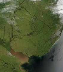
Español: Foto de Uruguay tomada desde satélite. Se aprecian claramente los límites con Brasil y Argentina, y el Río de la Plata al sur.
English: Photo of Uruguay taken from satellite, where the limits with Brazil and Argentina are clearly appreciated, as well as the Río de la Plata to the south. |
| Data | |
| Jatorria | http://visibleearth.nasa.gov/view_rec.php?id=4817 |
| Egilea | Jeff Schmaltz, MODIS Rapid Response Team, NASA/GSFC |
Lizentzia
| This file is in the public domain in the United States because it was solely created by NASA. NASA copyright policy states that "NASA material is not protected by copyright unless noted". (See Template:PD-USGov, NASA copyright policy page or JPL Image Use Policy.) | ||
 |
Warnings:
|
Fitxategiaren historia
Data/orduan klik egin fitxategiak orduan zuen itxura ikusteko.
| Data/Ordua | Iruditxoa | Neurriak | Erabiltzailea | Iruzkina | |
|---|---|---|---|---|---|
| oraingoa | 06:11, 29 azaroa 2004 | | 691 × 786 (1,18 MB) | Tano4595 | Uruguay_satelite |
Irudira dakarten loturak
Hurrengo orrialdeek dute fitxategi honetarako lotura:
Fitxategiaren erabilera orokorra
Hurrengo beste wikiek fitxategi hau darabilte:
- af.wikipedia.org proiektuan duen erabilera
- als.wikipedia.org proiektuan duen erabilera
- an.wikipedia.org proiektuan duen erabilera
- ar.wikipedia.org proiektuan duen erabilera
- ast.wikipedia.org proiektuan duen erabilera
- azb.wikipedia.org proiektuan duen erabilera
- ba.wikipedia.org proiektuan duen erabilera
- bg.wikipedia.org proiektuan duen erabilera
- ca.wikipedia.org proiektuan duen erabilera
- cs.wikipedia.org proiektuan duen erabilera
- da.wikipedia.org proiektuan duen erabilera
- de.wikipedia.org proiektuan duen erabilera
- el.wikipedia.org proiektuan duen erabilera
- en.wikipedia.org proiektuan duen erabilera
- en.wikibooks.org proiektuan duen erabilera
- eo.wikipedia.org proiektuan duen erabilera
- es.wikipedia.org proiektuan duen erabilera
- fr.wikipedia.org proiektuan duen erabilera
- gcr.wikipedia.org proiektuan duen erabilera
- hi.wikipedia.org proiektuan duen erabilera
- hr.wikipedia.org proiektuan duen erabilera
- hu.wikipedia.org proiektuan duen erabilera
- hy.wikipedia.org proiektuan duen erabilera
- hyw.wikipedia.org proiektuan duen erabilera
- is.wikipedia.org proiektuan duen erabilera
- it.wikipedia.org proiektuan duen erabilera
- ku.wikipedia.org proiektuan duen erabilera
- la.wikipedia.org proiektuan duen erabilera
- li.wikipedia.org proiektuan duen erabilera
- lv.wikipedia.org proiektuan duen erabilera
- ms.wikipedia.org proiektuan duen erabilera
- mt.wikipedia.org proiektuan duen erabilera
- oc.wikipedia.org proiektuan duen erabilera
- os.wikipedia.org proiektuan duen erabilera
- pcd.wikipedia.org proiektuan duen erabilera
- pl.wikipedia.org proiektuan duen erabilera
- pt.wikipedia.org proiektuan duen erabilera
Ikus fitxategi honen erabilpen global gehiago.