
Fitxategi:Zealandia, topographic map.jpg

Aurreikuspen honen neurria: 529 × 600 pixel. Bestelako bereizmenak: 212 × 240 pixel | 423 × 480 pixel | 678 × 768 pixel | 903 × 1.024 pixel | 1.500 × 1.700 pixel.
Bereizmen handikoa ((1.500 × 1.700 pixel, fitxategiaren tamaina: 4,57 MB, MIME mota: image/jpeg))
Fitxategi hau Wikimedia Commonsekoa da. Hango deskribapen orriko informazioa behean duzu. |
Laburpena
| Deskribapena |
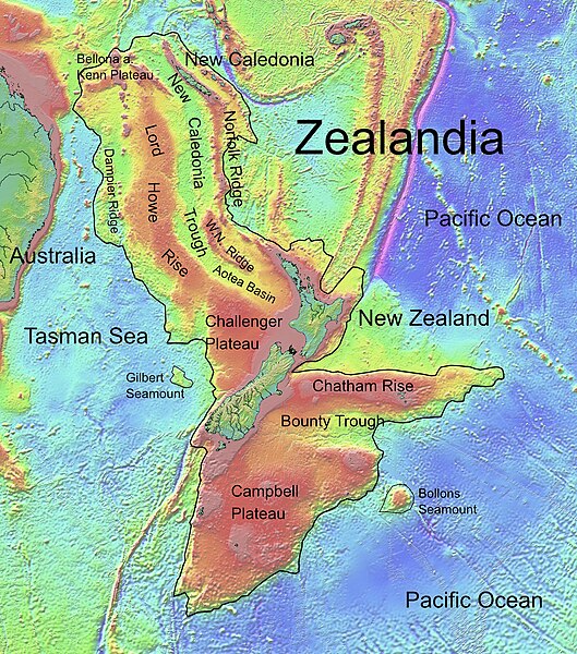
Deutsch: Die topografische Karte von Zealandia basiert auf den Bathymetrie-Daten des Scripps Institution of Oceanography, University of California, San Diego.
Die Umrandung zw. Grenzziehung basiert auf Informationen des Buches: Nick Mortimer; Hamish Campbell (2014) Zealandia - Our Continent Revealed, Londres: Penguin Books, p. 54 ISBN: 978-0-143-57156-8. English: Topographic map of Zealandia, based on bathymetry data from Scripps Institution of Oceanography, University of California, San Diego.
Boundary is based on information which was given in: Nick Mortimer; Hamish Campbell (2014) Zealandia - Our Continent Revealed, Londres: Penguin Books, p. 54 ISBN: 978-0-143-57156-8. Français : Carte topographique du continent de Zealandia, basée sur des données bathymétriques du Scripps Institution of Oceanography, Université de Californie, San Diego, États-Unis. La limite du continent est tirée d'informations venant de : « Nick Mortimer; Hamish Campbell (2014) Zealandia - Our Continent Revealed, Londres: Penguin Books, p. 54 ISBN: 978-0-143-57156-8. ». |
| Data | |
| Jatorria | http://topex.ucsd.edu/WWW_html/mar_topo.html; http://topex.ucsd.edu/marine_topo/jpg_images/topo10.jpg; http://topex.ucsd.edu/marine_topo/jpg_images/topo11.jpg; http://topex.ucsd.edu/marine_topo/jpg_images/topo14.jpg; http://topex.ucsd.edu/marine_topo/jpg_images/topo15.jpg |
| Egilea | Ulrich Lange, Bochum, Germany |
| Beste bertsioak |
 |
There is no copyright on published bathmetry data, (free use)
Lizentzia
Nik, lan honen egileak, argitaratzen dut ondorengo lizentzia pean:
| This file is made available under the Creative Commons CC0 1.0 Universal Public Domain Dedication. | |
| The person who associated a work with this deed has dedicated the work to the public domain by waiving all of their rights to the work worldwide under copyright law, including all related and neighboring rights, to the extent allowed by law. You can copy, modify, distribute and perform the work, even for commercial purposes, all without asking permission.
|
Fitxategiaren historia
Data/orduan klik egin fitxategiak orduan zuen itxura ikusteko.
| Data/Ordua | Iruditxoa | Neurriak | Erabiltzailea | Iruzkina | |
|---|---|---|---|---|---|
| oraingoa | 18:55, 9 otsaila 2019 | | 1.500 × 1.700 (4,57 MB) | Ulanwp | spelling of Bollons Seamount corrected |
| 22:43, 21 martxoa 2017 |  | 1.500 × 1.700 (4,57 MB) | Ulanwp | Geographical Names inserted | |
| 21:59, 20 martxoa 2017 |  | 1.500 × 1.700 (4,44 MB) | Ulanwp | {{Information |Description ={{en|1=Topographic map of Zealandia, based on bathmetry data from Scripps Institution of Oceanography, University of California, San Diego}} |Source =http://topex.ucsd.edu/WWW_html/mar_topo.html |Author =U... |
Irudira dakarten loturak
Hurrengo orrialdeek dute fitxategi honetarako lotura:
Fitxategiaren erabilera orokorra
Hurrengo beste wikiek fitxategi hau darabilte:
- ar.wikipedia.org proiektuan duen erabilera
- ast.wikipedia.org proiektuan duen erabilera
- bg.wikipedia.org proiektuan duen erabilera
- ca.wikipedia.org proiektuan duen erabilera
- ceb.wikipedia.org proiektuan duen erabilera
- de.wikipedia.org proiektuan duen erabilera
- Lord Howe Rise
- Zealandia
- Gisborne-Erdbeben von 2007
- Geologie Neuseelands
- Geographie Neuseelands
- Chatham Rise
- Campbell Plateau
- Bounty Trough
- Norfolk Ridge
- New Caledonia Trough
- Challenger Plateau
- Geologie der Antarktischen Halbinsel
- Geologie Ostantarktikas
- Vulkanische Provinzen der Antarktischen Halbinsel
- en.wikipedia.org proiektuan duen erabilera
- Chatham Rise
- Lord Howe Rise
- South Tasman Rise
- Campbell Plateau
- Meiolania
- Challenger Plateau
- Norfolk Ridge
- Lord Howe Seamount Chain
- Continent
- Submerged continent
- East Tasman Plateau
- Bollons Seamount
- Bounty Trough
- Tasmantid Seamount Chain
- Tasmantid hotspot
- Joseph Gilbert Seamount
- Gascoyne Seamount
- Geology of New Caledonia
- Taupo Bank
- Derwent Hunter Guyot
- Britannia Guyots
- Queensland Guyot
- Geology of Zealandia
- Three Kings Ridge
- es.wikipedia.org proiektuan duen erabilera
- fr.wikipedia.org proiektuan duen erabilera
Ikus fitxategi honen erabilpen global gehiago.