
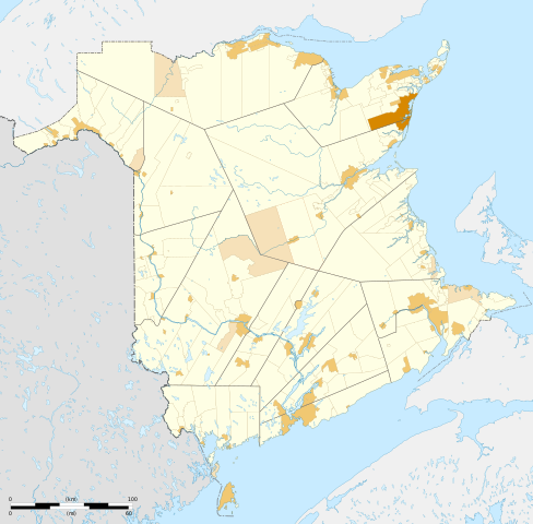
Fitxategi:Administrative areas of New Brunswick map-blank.svg

Bereizmen handikoa (SVG fitxategia, nominaldi 2.237 × 2.199 pixel, fitxategiaren tamaina: 1,47 MB)
Fitxategi hau Wikimedia Commonsekoa da. Hango deskribapen orriko informazioa behean duzu. |
Laburpena
| Deskribapena |
English: Blank map of administrative areas of New Brunswick, Canada. Legend: Local service district
Rural community
Municipality
Regional municipality
Each area can be selected and colored separately. It have an unique ID, easy to find (for example, Ctrl+F in Inkscape). See the area lists below. Equirectangular projection, WGS84 datum
Geographic limits of the map:
Français : Carte muette des divisions administratives du Nouveau-Brunswick, Canada. Légende : District de services locaux
Communauté rurale
Municipalité
Municipalité régionale
Chaque zone peut être sélectionnée et colorée séparément. Elles ont toutes un identifiant unique, facile à trouver (par exemple, Ctrl+F dans Inkscape). Voir les listes des zones ci-dessous. Projection équirectangulaire, système géodétique WGS84.
Limites géographiques de la carte :
|
||
| Data | |||
| Jatorria |
Norberak egina. English:
Français : |
||
| Egilea | Sémhur (talk) | ||
| Beste bertsioak |
Administrative areas of New Brunswick with First Nations lands map-blank.svg | ||
| Aitortu (required by the license) | © Sémhur / Wikimedia Commons / | ||
| SVG | W3C-validity not checked. Fitxategi hau (bektore-irudia) hau Inkscape-ekin sortu da .
.
|
||
| Graphic Lab |

| Kameraren kokapena | | Irudi hau eta gehiago beraien kokapenekin hurrengo lekuetan: OpenStreetMap |
|---|
Lizentzia
| Copyleft: This work of art is free; you can redistribute it and/or modify it according to terms of the Free Art License. You will find a specimen of this license on the Copyleft Attitude site as well as on other sites. |
- Askea zara:
- partekatzeko – lana kopiatzeko, banatzeko eta bidaltzeko
- birnahasteko – lana moldatzeko
- Ondorengo baldintzen pean:
- eskuduntza – Egiletza behar bezala aitortu behar duzu, lizentzia ikusteko esteka gehitu, eta ea aldaketak egin diren aipatu. Era egokian egin behar duzu hori guztia, baina inola ere ez egileak zure lana edo zure erabilera babesten duela irudikatuz.
- berdin partekatu – Lan honetan oinarrituta edo aldatuta berria eraikitzen baduzu, emaitza lana hau bezalako lizentzia batekin argitaratu behar duzu.
Lists
Local service district
p502300114__Saint-Francois
p502300115__Clair
p502300116__Lac_Baker
p502300117__Baker_Brook
p502300118__Saint-Hilaire
p502300119__Madawaska
p502300120__Saint-Jacques
p502300121__Saint-Joseph
p502300122__Saint-Basile
p502300123__Riviere-Verte
p502300124__Sainte-Anne
p502300125__Notre-Dame-de-Lourdes
p502300126__Saint-Leonard
p502300127__Saint-Andre
p502300129__Drummond
p502300130__Denmark
p502300131__Lorne
p502300132__Grand_Falls
p502300133__Riley_Brook
p502300207__Aberdeen
p502300208__Brighton
p502300209__Kent
p502300210__Northampton
p502300211__Peel
p502300212__Richmond
p502300213__Debec
p502300214__Simonds
p502300215__Wakefield
p502300216__Wicklow
p502300217__Wilmot
p502300218__Woodstock
p502300219__Benton
p502300220__Upper_Kent
p502300221__Coldstream
p502300222__Somerville
p502300223__Glassville
p502300227__Gordon
p502300228__Perth
p502300229__Andover
p502300230__Lakeville
p502300231__Upper_and_Lower_Northampton
p502300312__North_Lake
p502300313__Canterbury
p502300314__Dumfries
p502300315__Prince_William
p502300316__Kingsclear
p502300317__New_Maryland
p502300318__Manners_Sutton
p502300319__McAdam
p502300320__Southampton
p502300321__Queensbury
p502300322__Stanley
p502300323__Bright
p502300324__Douglas
p502300325__St._Mary_s
p502300326__Lincoln
p502300327__Burton
p502300328__Gladstone
p502300329__Blissville
p502300330__Maugerville
p502300331__Sheffield
p502300332__Northfield
p502300335__Upper_Miramichi
p502300336__Keswick_Ridge
p502300340__Canning
p502300341__Petersville
p502300342__Chipman
p502300343__Upper_Gagetown
p502300344__Wirral-Enniskillen
p502300345__Hampstead
p502300346__Gagetown
p502300347__Estey_s_Bridge
p502300348__Rusagonis-Waasis
p502300349__Noonan
p502300352__Brunswick
p502300353__Johnston
p502300354__Waterborough
p502300355__Cambridge
p502300356__Wickham
p502300416__Studholm
p502300417__Cardwell
p502300418__Kars
p502300419__Upham
p502300420__Waterford
p502300421__Hammond
p502300422__Kingston
p502300423__Havelock
p502300424__Springfield
p502300425__Norton
p502300426__Hampton
p502300427__Sussex
p502300428__Westfield_East
p502300429__Rothesay
p502300433__Greenwich
p502300507__Clarendon
p502300508__Campobello
p502300509__Dufferin
p502300510__Dumbarton
p502300511__Lepreau
p502300512__Pennfield
p502300513__Chamcook
p502300514__St._Croix
p502300515__St._George
p502300516__St._Patrick
p502300517__West_Isles
p502300518__St._Stephen
p502300519__St._David
p502300520__St._James
p502300521__White_Head_Island
p502300524__Beaver_Harbour
p502300525__Fundy_Bay
p502300527__Bayside
p502300528__Western_Charlotte
p502300529__Dennis-Weston
p502300552__St._Martins
p502300553__Simonds
p502300554__Fairfield
p502300555__Musquash
p502300614__Elgin_Parish
p502300615__Hillsborough
p502300616__Hopewell
p502300617__Harvey
p502300618__Coverdale
p502300620__Westmorland
p502300621__Botsford
p502300622__Shediac
p502300623__Sackville
p502300624__Dorchester
p502300625__Moncton
p502300626__Salisbury
p502300628__Elgin_Centre
p502300630__Pointe-du-Chene
p502300631__Cape_Tormentine
p502300632__Alma
p502300633__Bayfield
p502300635__Baie_Verte
p502300639__Point-de-Bute
p502300640__Murray_Corner
p502300642__Shediac_Cape
p502300643__Scoudouc_Road
p502300644__Shediac_River-Shediac_Bridge
p502300645__Scoudouc
p502300706__Acadieville
p502300707__Carleton
p502300708__St-Louis-de-Kent
p502300709__St._Charles_(Sud-Kent_Lake)
p502300710__Harcourt
p502300711__St._Paul
p502300712__Saint_Mary
p502300713__Wellington
p502300714__Weldford
p502300715__Dundas
p502300716__Richibucto
p502300717__Cap-de-Richibucto
p502300718__Pointe-Sapin
p502300719__Ste-Anne-de-Kent
p502300720__Aldouane
p502300721__Grand_Saint-Antoine
p502300725__St-Ignace
p502300728__Grand_Digue
p502300759__Alnwick
p502300760__Blackville
p502300761__Blissfield
p502300762__Chatham
p502300763__Derby
p502300764__Glenelg
p502300765__Hardwicke
p502300766__Upper_Miramichi
p502300767__Nelson
p502300768__Newcastle
p502300769__North_Esk
p502300770__South_Esk
p502300771__Rogersville
p502300772__Baie_Ste._Anne
p502300773__Tabusintac
p502300774__Escuminac
p502300775__Renous-Quarryville
p502300776__Oak_Point-Bartibog_Bridge
p502300777__Black_River-Hardwicke
p502300778__Haut_Riviere_de_Portage
p502300782__Portage_River-Tracadie_Beach
p502300783__Fair_Isle
p502300784__Ferry_Road-Russellville
p502300785__Sunny_Corner
p502300787__Brantville
p502300789__St._Margarets
p502300790__Colette
p502300817__New_Bandon
p502300818__Paquetville
p502300819__Parish_Saumarz
p502300820__Shippagan
p502300821__Saint-Isidore
p502300822__Beresford
p502300823__Allardville
p502300824__Bathurst
p502300825__Caraquet
p502300826__Pointe-Brulee
p502300828__Anse-Bleue
p502300829__Petit-Rocher_Sud
p502300831__Cap_Bâteau
p502300832__Chiasson-Savoy
p502300833__Inkerman_Centre
p502300834__Petite-Lameque
p502300835__Robertville
p502300837__Pigeon_Hill
p502300838__St._Simon
p502300839__Tremblay
p502300840__Ste._Cecile
p502300842__Pointe-Sauvage
p502300844__Benoit
p502300845__Haut_Lameque
p502300846__Petit-Rocher_Nord
p502300848__Dugas
p502300850__Baie_de_Petit_Pokemouche
p502300851__LaPlante
p502300852__Miscou_Island
p502300853__Pont_LaFrance
p502300854__Val_Comeau
p502300855__Saint_Pons
p502300856__Haut_Sheila
p502300857__Saint-Sauveur
p502300858__Pont_Landry
p502300859__Paroisse_Notre-Dame-des-erables
p502300863__North_Tetagouche
p502300864__Leech
p502300865__Saint_Irenee_and_Alderwood
p502300866__Saumarez
p502300867__Poirier
p502300868__Pointe_Canot
p502300869__Blanchard_Settlement
p502300870__Côteau_Road
p502300871__Maltempec
p502300872__Pokemouche
p502300873__Sainte-Rose
p502300874__Evangeline
p502300875__Pointe-â-Bouleau
p502300876__Landry_Office
p502300877__Pokesudie
p502300878__Dunlop
p502300879__Riviere_a_la_Truite
p502300880__Haut_Shippagen
p502300881__Big_River
p502300882__Gauvreau_Petit_Tracadie
p502300883__Madran
p502300887__New_Bandon-Salmon_Beach
p502300888__Pointe-Alexandre
p502300906__Blair_Athol
p502300912__St._Quentin
p502300914__St._Jean_Baptiste_de_Restigouche
p502300915__Eldon
p502300916__Addington
p502300917__Dalhousie
p502300918__Balmoral-Maltais
p502300921__Flatlands
p502300922__Balmoral-St-Maure
p502300923__St._Martin
p502300924__Dalhousie_Junction
p502300925__Dundee
p502300927__McLeod
p502300929__Mann_s_Mountain
p502300930__Point_La_Nim
p502300931__Glencoe
p502300934__Menneval
p502300935__White_s_Brook
p502300936__Lorne
p502300937__Chaleur
p502300938__Inkerman
Municipalities
p500300001__Village_of_Alma
p500300002__Village_of_Aroostook
p500300003__Village_of_Atholville
p500300004__Baker_Brook
p500300005__Village_of_Balmoral
p500300006__Village_of_Bas-Caraquet
p500300007__Village_of_Bath
p500300008__City_of_Bathurst
p500300009__Belledune
p500300010__Beresford
p500300011__Bertrand
p500300012__Blacks_Harbour
p500300013__Village_of_Blackville
p500300014__Bouctouche
p500300016__Village_of_Cambridge-Narrows
p500300017__City_of_Campbellton
p500300018__Village_of_Canterbury
p500300019__Village_de_Cap-Pele
p500300020__Town_of_Caraquet
p500300021__Centreville
p500300022__Village_of_Charlo
p500300023__Village_of_Chipman
p500300024__Village_of_Clair
p502300722__Cocagne
p500300025__Town_of_Dalhousie
p500300026__Dieppe
p500300027__Village_of_Doaktown
p500300028__Village_of_Dorchester
p500300029__Village_of_Drummond
p500300030__Edmundston
p500300031__Village_of_Eel_River_Crossing
p500300032__Florenceville-Bristol
p500300033__The_City_of_Fredericton
p500300034__Village_of_Fredericton_Junction
p500300035__Village_of_Gagetown
p500300036__Grand_Bay-Westfield
p500300037__The_Town_of_Grand_Falls-La_Ville_de_Grand-Sault
p500300038__Grand_Manan
p500300039__Grande-Anse
p500300040__Hampton
p502300337__Hanwell
p500300041__Town_of_Hartland
p500300042__Village_of_Harvey
p500300043__Village_of_Hillsborough
p500300044__Village_of_Kedgwick
p500300045__Village_of_Lac_Baker
p500300046__Lameque
p500300047__Le_Goulet
p500300048__Maisonnette
p500300049__Village_of_McAdam
p500300050__Meductic
p500300051__Memramcook
p500300052__Millville
p500300053__Village_of_Minto
p500300054__Miramichi
p500300055__Moncton
p500300056__Nackawic
p500300057__Neguac
p500300058__New_Maryland
p500300059__Nigadoo
p500300060__Village_of_Norton
p500300061__Oromocto
p500300062__Village_of_Paquetville
p500300063__Village_of_Perth-Andover
p500300064__Village_of_Petitcodiac
p500300065__Village_of_Petit_Rocher
p500300066__Plaster_Rock
p500300067__Village_de_Pointe-Verte
p500300068__Village_of_Port_Elgin
p500300069__Quispamsis
p500300070__Village_of_Rexton
p500300071__Richibucto
p500300072__Village_of_Riverside-Albert
p500300073__The_Town_of_Riverview
p500300074__Village_of_Riviere-Verte
p500300075__Rogersville
p500300076__Rothesay
p500300077__Town_of_Sackville
p500300078__Town_of_Saint_Andrews
p500300079__Town_of_St._George
p500300080__The_City_of_Saint_John
p500300081__Saint-Leolin
p500300082__Saint-Quentin
p500300083__Village_of_Sainte-Anne-de-Madawaska
p500300084__Village_de_Saint-Antoine
p500300085__Village_of_Saint-Francois_de_Madawaska
p500300086__Saint-Isidore
p500300087__Saint-Louis_de_Kent
p500300088__Salisbury
p500300089__Shediac
p500300090__Town_of_Shippagan
p500300091__Village_de_St._Andre
p500300092__Village_de_St._Hilaire
p500300093__Town_of_St._Leonard
p500300094__Village_of_St._Martins
p500300095__The_Town_of_St._Stephen
p500300096__Village_of_Stanley
p500300097__Sainte-Marie-Saint-Raphael
p500300098__Town_of_Sussex
p500300099__Village_of_Sussex_Corner
p500300100__Village_of_Tide_Head
p500300101__Tracadie
p500300102__Village_of_Tracy
p500300103__Woodstock
p500300104__Beaubassin_East
Note: Grimmer (502300913) has been almalgamated with Kedgwick on July 1st 2012 to create a rural community. Grimmer (502300913) a été fusionné avec Kedgwick le 21 juillet 2012 pour former une communauté rurale.
Fitxategiaren historia
Data/orduan klik egin fitxategiak orduan zuen itxura ikusteko.
| Data/Ordua | Iruditxoa | Neurriak | Erabiltzailea | Iruzkina | |
|---|---|---|---|---|---|
| oraingoa | 21:38, 3 uztaila 2015 | | 2.237 × 2.199 (1,47 MB) | Red Castle | Annexion de Dundee à Eel River Crossing |
| 07:43, 3 uztaila 2015 |  | 2.237 × 2.199 (1,47 MB) | Red Castle | Renommage de Tracadie | |
| 07:26, 3 uztaila 2015 |  | 2.237 × 2.199 (1,47 MB) | Red Castle | Renommage du Grand Tracadie-Sheila, annexion de Val-d'Amour et Saint-Arthur à Atholville. | |
| 05:23, 7 uztaila 2014 |  | 2.237 × 2.199 (1,47 MB) | Red Castle | comtés | |
| 00:03, 6 uztaila 2014 |  | 2.237 × 2.199 (1,47 MB) | Red Castle | code valide | |
| 00:00, 6 uztaila 2014 |  | 2.237 × 2.199 (1,47 MB) | Red Castle | code valide | |
| 23:44, 5 uztaila 2014 |  | 2.237 × 2.199 (1,47 MB) | Red Castle | Nouvelle municipalité régionale: Grand Tracadie-Sheila | |
| 11:22, 26 maiatza 2014 |  | 2.237 × 2.199 (1,5 MB) | Sémhur | Valid SVG | |
| 02:20, 25 maiatza 2014 |  | 2.237 × 2.199 (1,5 MB) | Red Castle | Mise à jour Hanwell et Cocagne | |
| 19:30, 12 abuztua 2012 |  | 2.237 × 2.199 (1,5 MB) | Dr Wilson | Minor correction. |
Irudira dakarten loturak
Hurrengo orrialdeek dute fitxategi honetarako lotura:
Fitxategiaren erabilera orokorra
Hurrengo beste wikiek fitxategi hau darabilte:
- fr.wikipedia.org proiektuan duen erabilera