
Fitxategi:Atoll forming-i18.png

Aurreikuspen honen neurria: 412 × 599 pixel. Bestelako bereizmenak: 165 × 240 pixel | 330 × 480 pixel | 528 × 768 pixel | 704 × 1.024 pixel | 1.667 × 2.423 pixel.
Bereizmen handikoa ((1.667 × 2.423 pixel, fitxategiaren tamaina: 486 KB, MIME mota: image/png))
Fitxategi hau Wikimedia Commonsekoa da. Hango deskribapen orriko informazioa behean duzu. |
Laburpena
| Deskribapena |
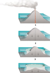
Internationalization of the diagram:Atoll forming. |
| Jatorria | http://commons.wikimedia.org/wiki/Image:Atoll_forming.jpg |
| Egilea | Susan Mayfield and Sara Boore, modified by Eurico Zimbres |
| Lizentzia (Fitxategi hau berrerabiltzen) |
Free for all use |
| Beste bertsioak |
Derivative works of this file: |
Lizentzia
This image is in the public domain in the United States because it only contains materials that originally came from the United States Geological Survey, an agency of the United States Department of the Interior. For more information, see the official USGS copyright policy.
|

|
Irudi hau birsortu beharko litzateke SVG irudi bektorial moduan. Honek abantaila asko ematen ditu, ikus Commons:Media for cleanup (ingelesez) informazio gehiagorako. Irudi honen SVG bertsioa eskuragarri badago, mesedez Commonsera igo. Igo ostean, ordezkatu txantiloi hau txantiloi honegatik {{vector version available|irudiaren izen berria.svg}} irudi honetan.
|
Fitxategiaren historia
Data/orduan klik egin fitxategiak orduan zuen itxura ikusteko.
| Data/Ordua | Iruditxoa | Neurriak | Erabiltzailea | Iruzkina | |
|---|---|---|---|---|---|
| oraingoa | 20:32, 29 maiatza 2006 | | 1.667 × 2.423 (486 KB) | Zimbres | {{Information |Description= Internationalization of the diagram:Atoll forming.<br> '''1'''=Volcanic Island<br> '''2'''=Fringind reef<br> '''3'''=Barrier reeef<br> |Source=http://commons.wikimedia.org/wiki/Image:Atoll_forming.jpg |Date= |Author=USGS/USGov |
Irudira dakarten loturak
Hurrengo orrialdeek dute fitxategi honetarako lotura:
Fitxategiaren erabilera orokorra
Hurrengo beste wikiek fitxategi hau darabilte:
- az.wikipedia.org proiektuan duen erabilera
- be-tarask.wikipedia.org proiektuan duen erabilera
- be.wikipedia.org proiektuan duen erabilera
- es.wikipedia.org proiektuan duen erabilera
- fi.wikipedia.org proiektuan duen erabilera
- ja.wikipedia.org proiektuan duen erabilera
- kbd.wikipedia.org proiektuan duen erabilera
- lt.wikipedia.org proiektuan duen erabilera
- mdf.wikipedia.org proiektuan duen erabilera
- nn.wikipedia.org proiektuan duen erabilera
- pl.wikipedia.org proiektuan duen erabilera
- ru.wikipedia.org proiektuan duen erabilera
- ru.wiktionary.org proiektuan duen erabilera
- uk.wikipedia.org proiektuan duen erabilera
- www.wikidata.org proiektuan duen erabilera