
Fitxategi:BNR (Ruthienie Blanche) Map 1918.jpg

Bereizmen handikoa ((4.400 × 3.015 pixel, fitxategiaren tamaina: 10,27 MB, MIME mota: image/jpeg))
Fitxategi hau Wikimedia Commonsekoa da. Hango deskribapen orriko informazioa behean duzu. |
_Map_1918.jpg)
Laburpena
| Izenburua |
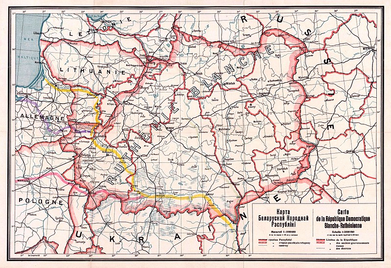
Беларуская: Карта Беларускай Народнай Рэспублікі, 1918 Беларуская (тарашкевіца): Мапа Беларускай Народнай Рэспублікі, 1918
English: Map of the territory claimed by the Belarusian People's Republic (published in 1918).
Русский: Карта Белорусской Народной Республики, 1918
Українська: Карта Білоруської Народної Республіки, 1918 |
| Data | |
| Jatorria |
1. Карта БНР 1918 год, IMAGO.BY 2. Originally uploaded to English Wikipedia by Rydel (21:53, 2 January 2005) as en:Image:BNR ruthienie blanche.jpg. |
| Sortzailea |
Ezezaguna |
| Georeferencing | If inappropriate please set warp_status = skip to hide. |
Lizentzia
|
Lan hau jabetza publikoan dago bai bere jatorrizko herrialdean, bai egile eskubideak egilea hil eta 70 urtera edo gutxiagora iraungitzen diren gainerako herrialdeetan.
| |
| This file has been identified as being free of known restrictions under copyright law, including all related and neighboring rights. | |
Fitxategiaren historia
Data/orduan klik egin fitxategiak orduan zuen itxura ikusteko.
| Data/Ordua | Iruditxoa | Neurriak | Erabiltzailea | Iruzkina | |
|---|---|---|---|---|---|
| oraingoa | 15:56, 26 urria 2017 | | 4.400 × 3.015 (10,27 MB) | Kazimier Lachnovič | better quality |
| 16:18, 3 iraila 2005 |  | 1.000 × 700 (195 KB) | EugeneZelenko | Map of Belarusian National Republic (published in 1918). Originally uploaded to English Wikipedia by Rydel (21:53, 2 January 2005) as en:Image:BNR ruthienie blanche.jpg. Category:Historical maps of Belarus |
Irudira dakarten loturak
Hurrengo orrialdeek dute fitxategi honetarako lotura:
Fitxategiaren erabilera orokorra
Hurrengo beste wikiek fitxategi hau darabilte:
- ar.wikipedia.org proiektuan duen erabilera
- ast.wikipedia.org proiektuan duen erabilera
- be-tarask.wikipedia.org proiektuan duen erabilera
- be.wikipedia.org proiektuan duen erabilera
- bg.wikipedia.org proiektuan duen erabilera
- ca.wikipedia.org proiektuan duen erabilera
- cs.wikipedia.org proiektuan duen erabilera
- cy.wikipedia.org proiektuan duen erabilera
- da.wikipedia.org proiektuan duen erabilera
- de.wikipedia.org proiektuan duen erabilera
- en.wikipedia.org proiektuan duen erabilera
- eo.wikipedia.org proiektuan duen erabilera
- es.wikipedia.org proiektuan duen erabilera
- et.wikipedia.org proiektuan duen erabilera
- fr.wikipedia.org proiektuan duen erabilera
- hu.wikipedia.org proiektuan duen erabilera
Ikus fitxategi honen erabilpen global gehiago.
_Map_1918.jpg)
_Map_1918.jpg)