
Fitxategi:Boundary map of Venice neighborhood in Los Angeles, California.png
Boundary_map_of_Venice_neighborhood_in_Los_Angeles,_California.png ((443 × 398 pixel, fitxategiaren tamaina: 235 KB, MIME mota: image/png))
Fitxategi hau Wikimedia Commonsekoa da. Hango deskribapen orriko informazioa behean duzu. |
Laburpena
| Deskripzio |
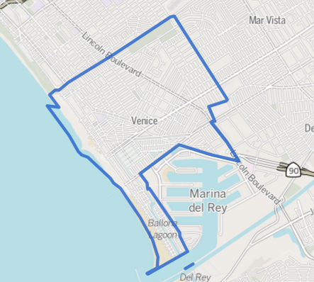
This map was created from OpenStreetMap project data, collected by the community. This map may be incomplete, and may contain errors. Don't rely solely on it for navigation. |
|||
| Data | 2013ko ekainaren 12a (igoera data) | |||
| Jatorria | openstreetmap.org | |||
| Sortzailea |
OpenStreetMap contributers; boundary lines added here by the Los Angeles Times OpenStreetMap contributors |
|||
| Lizentzia (Fitxategi hau berrerabiltzen) |
OpenStreetMap data is available under the Open Database License (details). Map tiles are licensed under the Creative Commons Attribution-ShareAlike 2.0 license (CC-BY-SA 2.0).
This file is licensed under the Creative Commons Attribution-Share Alike 2.0 Generic license.
|
|||
| Georeferencing | If inappropriate please set warp_status = skip to hide. |
Jatorrizko igoera erregistroa
Transferred from en.wikipedia to Commons using For the Common Good.
| Data/Ordua | Neurriak | Erabiltzailea | Iruzkina |
|---|---|---|---|
| 23:54, 12 June 2013 | 443 × 398 (240,854 bytes) | w:en:GeorgeLouis (eztabaida | ekarpenak) | (Uploading a file from a free published source using [[Wikipedia:File_Upload_Wizard|File Upload Wizard]]) |
Fitxategiaren historia
Data/orduan klik egin fitxategiak orduan zuen itxura ikusteko.
| Data/Ordua | Iruditxoa | Neurriak | Erabiltzailea | Iruzkina | |
|---|---|---|---|---|---|
| oraingoa | 07:10, 18 ekaina 2013 | | 443 × 398 (235 KB) | ALH | Transferred from en.wikipedia: see original upload log above |
Irudira dakarten loturak
Hurrengo orrialdeek dute fitxategi honetarako lotura:
Fitxategiaren erabilera orokorra
Hurrengo beste wikiek fitxategi hau darabilte:
- af.wikipedia.org proiektuan duen erabilera
- ar.wikipedia.org proiektuan duen erabilera
- azb.wikipedia.org proiektuan duen erabilera
- ca.wikipedia.org proiektuan duen erabilera
- ceb.wikipedia.org proiektuan duen erabilera
- cs.wikipedia.org proiektuan duen erabilera
- en.wikipedia.org proiektuan duen erabilera
- eo.wikipedia.org proiektuan duen erabilera
- es.wikipedia.org proiektuan duen erabilera
- fa.wikipedia.org proiektuan duen erabilera
- fi.wikipedia.org proiektuan duen erabilera
- fo.wikipedia.org proiektuan duen erabilera
- fr.wikipedia.org proiektuan duen erabilera
- it.wikipedia.org proiektuan duen erabilera
- it.wikivoyage.org proiektuan duen erabilera
- la.wikipedia.org proiektuan duen erabilera
- uk.wikipedia.org proiektuan duen erabilera
- ur.wikipedia.org proiektuan duen erabilera
- www.wikidata.org proiektuan duen erabilera