Fitxategi:Byzantine Constantinople-en.png

Orriaren edukia ez da onartzen beste hizkuntza batzuetan.
Wikipedia, Entziklopedia askea

Bereizmen handikoa((3.200 × 2.888 pixel, fitxategiaren tamaina: 2,35 MB, MIME mota: image/png))

Fitxategi hau Wikimedia Commonsekoa da. Hango deskribapen orriko informazioa behean duzu.
Commons gordailu bat da, lizentzia askea duten multimedia fitxategiena. Lagun dezakezu.

Fitxategi hau Wikimedia Commonsekoa da

Wikipedia

 This is a featured picture on the English language Wikipedia (Featured pictures) and is considered one of the finest images.

If you think this file should be featured on Wikimedia Commons as well, feel free to nominate it.
If you have an image of similar quality that can be published under a suitable copyright license, be sure to upload it, tag it, and nominate it.

Laburpena

Deskribapena
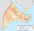
English: Topographical map of Constantinople during the Byzantine period.
Български: Топографска карта на Константинопол (Цариград) през византийския период. Източник: R. Janin, Constantinople Byzantine. Developpement urbain et repertoire topographique. Пътната мрежа и някои други детайли се основават на Dumbarton Oaks Papers 54 и други публикувани източници.
Deutsch: Topografische Karte Konstantinopels während des byzantinischen Zeitraums. Quelle: R. Janin, Constantinople Byzantine. Developpement urbain et repertoire topographique. Straßennetz und andere Einzelheiten basiert auf Dumbarton Oaks Papers 54. Kirchen, insb. nicht identifizierte und ausgegrabene Bauten sind aus dem The Byzantine Churches of Istanbul entnommen. Andere herausgegebenen Quellen wurden behilfsmäßig gebraucht.
Ελληνικά: Τοπογραφικός χάρτης Κωνσταντινουπόλεως κατά τη Βυζαντινή περίοδο. Βασική πηγή χάρτη: R. Janin, Constantinople Byzantine. Developpement urbain et repertoire topographique. Το οδικό δίκτυο και διάφορες άλλες λεπτομέρειες με βάση το Dumbarton Oaks Papers 54. Πληροφορίες για τις εκκλησίες, ιδιαίτερα τις μη ταυτοποιημένες, από την ιστοσελίδα The Byzantine Churches of Istanbul του Πανεπιστημίου της Νέας Υόρκης.
Although I've striven to make this map as complete and correct as possible, there may be some errors or omissions. Any corrections & suggestions are welcome.
Data
Jatorria

Own work using:

Egilea Cplakidas
Lizentzia
(Fitxategi hau berrerabiltzen)
Nik, lan honen egileak, argitaratzen dut ondorengo lizentzia hauen pean:
w:eu:Creative Commons
eskuduntza berdin partekatu
Fitxategi hau Creative Commons Attribution-Share Alike 3.0 Unported lizentziapean dago.
Askea zara:
  • partekatzeko – lana kopiatzeko, banatzeko eta bidaltzeko
  • birnahasteko – lana moldatzeko
Ondorengo baldintzen pean:
  • eskuduntza – Egiletza behar bezala aitortu behar duzu, lizentzia ikusteko esteka gehitu, eta ea aldaketak egin diren aipatu. Era egokian egin behar duzu hori guztia, baina inola ere ez egileak zure lana edo zure erabilera babesten duela irudikatuz.
  • berdin partekatu – Lan honetan oinarrituta edo aldatuta berria eraikitzen baduzu, emaitza lana hau bezalako lizentzia batekin argitaratu behar duzu.
GNU head Baimena duzu dokumentu hau kopiatu, banatu edo/eta aldatzeko GNU Free Documentation License baldintzapean, Free Software Foundationek argitaratutako 1.2 edo ondorengo bertsioan; sekzio aldaezinik gabe, azaleko testurik gabe, eta atzeko azaleko testurik gabe. Lizentziaren kopia dago GNU Free Documentation License izenburudun atalean.
Nahiago duzun lizentzia erabil dezakezu.
Beste bertsioak

[aldatu]

Full maps

SVG:

PNG:

Numeric versions

Regions

Roads

Open this image as an overlay in Google Earth (Google Maps, Bing) (Help|Source)

Irudi-oineko testuak

Add a one-line explanation of what this file represents
Constantinople during the Byzantine period

Fitxategi honetan agertzen diren itemak

honako hau irudikatzen du

28 urria 2008

media type ingelesa

image/png

checksum ingelesa

b4b5347456038e42cfa57b6c9763eaefb8d38a55

data size ingelesa

2.462.235 Byte

2.888 pixel

3.200 pixel

Fitxategiaren historia

Data/orduan klik egin fitxategiak orduan zuen itxura ikusteko.

Data/OrduaIruditxoaNeurriakErabiltzaileaIruzkina
oraingoa19:42, 25 apirila 201019:42, 25 apirila 2010 bertsioaren iruditxoa3.200 × 2.888 (2,35 MB)MahahahaneapneapCompressed
14:56, 15 abendua 200914:56, 15 abendua 2009 bertsioaren iruditxoa3.200 × 2.888 (3,42 MB)Cplakidaslarger & more detailed version, various corrections, Galata included
01:08, 1 uztaila 200901:08, 1 uztaila 2009 bertsioaren iruditxoa2.134 × 2.000 (1,62 MB)FalcorianLossless compression with pngout.
00:47, 9 urtarrila 200900:47, 9 urtarrila 2009 bertsioaren iruditxoa2.134 × 2.000 (1,84 MB)Cplakidasmore info, minor tweaks & corrections
13:48, 28 urria 200813:48, 28 urria 2008 bertsioaren iruditxoa2.134 × 2.000 (1,76 MB)Cplakidas{{Information |Description={{en|1=Topographical map of Constantinople during the Byzantine period. Map source: R. Janin, ''Constantinople Byzantine. Developpement urbain et repertoire topographique''. Road network and some other d

Ez dago fitxategi hau darabilen orririk.

Fitxategiaren erabilera orokorra

Hurrengo beste wikiek fitxategi hau darabilte:

Ikus fitxategi honen erabilpen global gehiago.

Metadatuak