
Fitxategi:Chile-Chonos Archipelago.jpg
Bereizmen handikoa ((1.032 × 1.276 pixel, fitxategiaren tamaina: 572 KB, MIME mota: image/jpeg))
Fitxategi hau Wikimedia Commonsekoa da. Hango deskribapen orriko informazioa behean duzu. |
Laburpena
| Deskribapena |
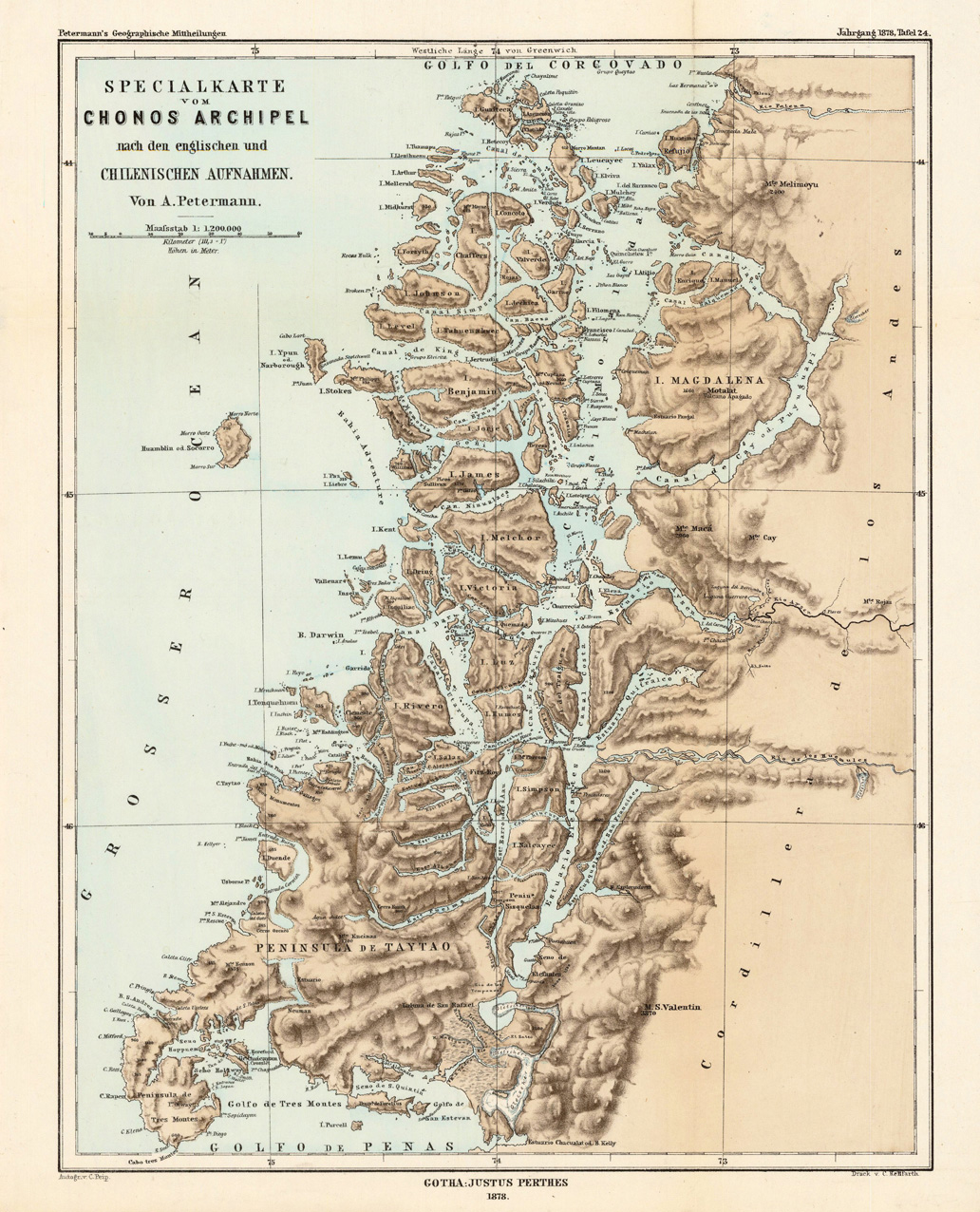
English: Lithograph, printed in colors when published. Detailled map, showing the Chonos Archipel from the gulf of Penas with the Peninsula de Taytao up to the gulf of Corcovado. Very detailled map with an enormous number of islands and peninsulas, most of them with place names. The map provides an overview of the results of the travel by Th. von Heugelin to Somalia. It is also ornated with a scene of birds and mammals, which were discovered by Th. Heugelin in Somalia. |
| Data | |
| Jatorria | http://www.bergbook.com/htdocs/woda/data/demo/descriptions/17333.htm |
| Egilea | Petermann, A. |
Lizentzia
|
Lan hau jabetza publikoan dago bai bere jatorrizko herrialdean, bai egile eskubideak egilea hil eta 70 urtera edo gutxiagora iraungitzen diren gainerako herrialdeetan.
| |
| This file has been identified as being free of known restrictions under copyright law, including all related and neighboring rights. | |
Fitxategiaren historia
Data/orduan klik egin fitxategiak orduan zuen itxura ikusteko.
| Data/Ordua | Iruditxoa | Neurriak | Erabiltzailea | Iruzkina | |
|---|---|---|---|---|---|
| oraingoa | 04:43, 24 otsaila 2010 | | 1.032 × 1.276 (572 KB) | Rec79 | {{Information |Description={{en|1=Lithograph, printed in colors when published. Detailled map, showing the Chonos Archipel from the gulf of Penas with the Peninsula de Taytao up to the gulf of Corcovado. Very detailled map with an enormous number of islan |
Irudira dakarten loturak
Ez dago fitxategi hau darabilen orririk.
Fitxategiaren erabilera orokorra
Hurrengo beste wikiek fitxategi hau darabilte:
- ca.wikipedia.org proiektuan duen erabilera
- de.wikipedia.org proiektuan duen erabilera
- en.wikipedia.org proiektuan duen erabilera
- es.wikipedia.org proiektuan duen erabilera
- fr.wikipedia.org proiektuan duen erabilera
- fr.wiktionary.org proiektuan duen erabilera
- gl.wikipedia.org proiektuan duen erabilera
- it.wikipedia.org proiektuan duen erabilera
- lt.wikipedia.org proiektuan duen erabilera
- lv.wikipedia.org proiektuan duen erabilera
- nn.wikipedia.org proiektuan duen erabilera
- ru.wikipedia.org proiektuan duen erabilera
- sh.wikipedia.org proiektuan duen erabilera
- www.wikidata.org proiektuan duen erabilera