
Fitxategi:Cyprus ESA356100.jpg

Bereizmen handikoa ((10.000 × 7.196 pixel, fitxategiaren tamaina: 82,48 MB, MIME mota: image/jpeg))
Fitxategi hau Wikimedia Commonsekoa da. Hango deskribapen orriko informazioa behean duzu. |
Laburpena
| Warning | The original file is very high-resolution. It might not load properly or could cause your browser to freeze when opened at full size. |
|---|
| Deskribapena |
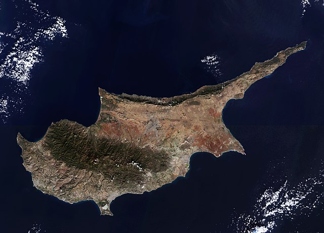
English: The third largest island in the Mediterranean, Cyprus is about 240 km long and 100 km wide. It is located on the Anatolian plate and therefore belongs geologically to Asia, but politically it is a member of the EU.
The Troodos mountains dominate the centre of the island and include Mount Olympus, the country’s highest mountain at 1952 m. Along the northern coast, the smaller Kyrenia Range rises suddenly from the plains. The capital and largest city, Nicosia, sits between the two mountain ranges. Since 1974 the island has been split between the Greek Cypriot and Turkish Cypriot populations, with the line of separation running through the city. East of Nicosia lies the Mesaoria plain, which is the agricultural heartland of the island – but depends greatly on winter rainfall and irrigation, limiting its production. High summer temperatures further exacerbate the situation. Thousands of years ago the area was covered by thick forest, but most of this was cut down to provide wood for the Ptolemaic dynasty’s navy in the 1st century BC. Today, much of the plain is covered by hard-packed calcium carbonate. At the southernmost area of Cyprus we can see the Limassol Salt Lake, the largest inland body of water on the island. Covering over 10 sq km, the lake is an important stopover for birds migrating between Africa and Europe, with greater flamingos spending the winter months there. Further up the coast to the east is the seasonal Larnaca Salt Lake, which also sees flamingos. This image – also featured on theEarth from Space video programme– comprises two scans from the Sentinel-2A satellite on the same day: 22 December 2015. |
| Data | |
| Jatorria | http://www.esa.int/spaceinimages/Images/2016/03/Cyprus |
| Egilea | European Space Agency |
| Lizentzia (Fitxategi hau berrerabiltzen) |
Copernicus Sentinel data (2015)/ESA,CC BY-SA 3.0 IGO |
| Beste bertsioak |
|
| Title | Cyprus |
| Set | Earth observation image of the week |
| System | Copernicus |
| Mission | Sentinel-2 |
| Location | Cyprus |
| Activity | Observing the Earth |
| Keywords | Satellite image; Islands; Coast; Coast line; Mountain |
.jpg)
.jpg)

Lizentzia
- Askea zara:
- partekatzeko – lana kopiatzeko, banatzeko eta bidaltzeko
- birnahasteko – lana moldatzeko
- Ondorengo baldintzen pean:
- eskuduntza – Egiletza behar bezala aitortu behar duzu, lizentzia ikusteko esteka gehitu, eta ea aldaketak egin diren aipatu. Era egokian egin behar duzu hori guztia, baina inola ere ez egileak zure lana edo zure erabilera babesten duela irudikatuz.
- berdin partekatu – Lan honetan oinarrituta edo aldatuta berria eraikitzen baduzu, emaitza lana hau bezalako lizentzia batekin argitaratu behar duzu.

|
This image contains data from a satellite in the Copernicus Programme, such as Sentinel-1, Sentinel-2 or Sentinel-3. Attribution is required when using this image.
Aitortu: Contains modified Copernicus Sentinel data {{{year}}}
The use of Copernicus Sentinel Data is regulated under EU law (Commission Delegated Regulation (EU) No 1159/2013 and Regulation (EU) No 377/2014). Relevant excerpts:
Free access shall be given to GMES dedicated data [...] made available through GMES dissemination platforms [...].
Access to GMES dedicated data [...] shall be given for the purpose of the following use in so far as it is lawful:
GMES dedicated data [...] may be used worldwide without limitations in time.
GMES dedicated data and GMES service information are provided to users without any express or implied warranty, including as regards quality and suitability for any purpose. |
Fitxategiaren historia
Data/orduan klik egin fitxategiak orduan zuen itxura ikusteko.
| Data/Ordua | Iruditxoa | Neurriak | Erabiltzailea | Iruzkina | |
|---|---|---|---|---|---|
| oraingoa | 13:12, 14 urtarrila 2021 | | 10.000 × 7.196 (82,48 MB) | StellarHalo | higher resolution |
| 22:27, 7 maiatza 2017 |  | 1.920 × 1.382 (1,7 MB) | Fæ | European Space Agency, Id 356100, http://www.esa.int/spaceinimages/Images/2016/03/Cyprus, User:Fæ/Project_list/ESA |
Irudira dakarten loturak
Hurrengo orrialdeek dute fitxategi honetarako lotura:
Fitxategiaren erabilera orokorra
Hurrengo beste wikiek fitxategi hau darabilte:
- bg.wikipedia.org proiektuan duen erabilera
- en.wikipedia.org proiektuan duen erabilera
- Cyprus warbler
- .cy
- Pancyprian Federation of Labour
- Cyprus Postal Services
- Greek Cypriots in Northern Cyprus
- TAK-Cyprus
- Conscription in Cyprus
- National Federation of Cypriots
- Cyprus Stock Exchange
- Template:Cyprus-stub
- Cyprus dipper
- Cyprus spiny mouse
- Modinos v. Cyprus
- Greek Cypriot diaspora
- Democratic Labour Federation of Cyprus
- Cyprus Workers' Confederation
- Revolutionary Trade Unions Federation
- Cyprus Union of Bank Employees
- Pancyprian Public Servants' Trade Union
- Extreme points of Cyprus
- Agapenor
- Capital punishment in Cyprus
- Athina Sat
- Cypriot mouse
- Ten city-kingdoms of Cyprus
- Maratheftiko
- Moufflon Publications
- Cyprus Regiment
- Universal Life (Cyprus)
- Episkopi Cantonment
- Battle of Spilia
- Cyprus brandy
- Radio Proto
- Radio Astra
- RIK 1
- Logos Radio
- METRO Foods Trading
- Scouting and Guiding in Cyprus
- Idol of Pomos
- Woolworths (Cyprus)
- Cyprus State Fairs Authority
- Cyprus Automobile Association
- Law enforcement in Northern Cyprus
- Cypriot passport
- Cyprus Institute of Marketing
- Cyprus Development Bank
- Postal orders of Cyprus
- Omega TV Cyprus
Ikus fitxategi honen erabilpen global gehiago.