
Fitxategi:CzechRepCitiesTowns.png

Aurreikuspen honen neurria: 800 × 474 pixel. Bestelako bereizmenak: 320 × 190 pixel | 640 × 379 pixel | 930 × 551 pixel.
Bereizmen handikoa ((930 × 551 pixel, fitxategiaren tamaina: 35 KB, MIME mota: image/png))
Fitxategi hau Wikimedia Commonsekoa da. Hango deskribapen orriko informazioa behean duzu. |
| Deskribapena |
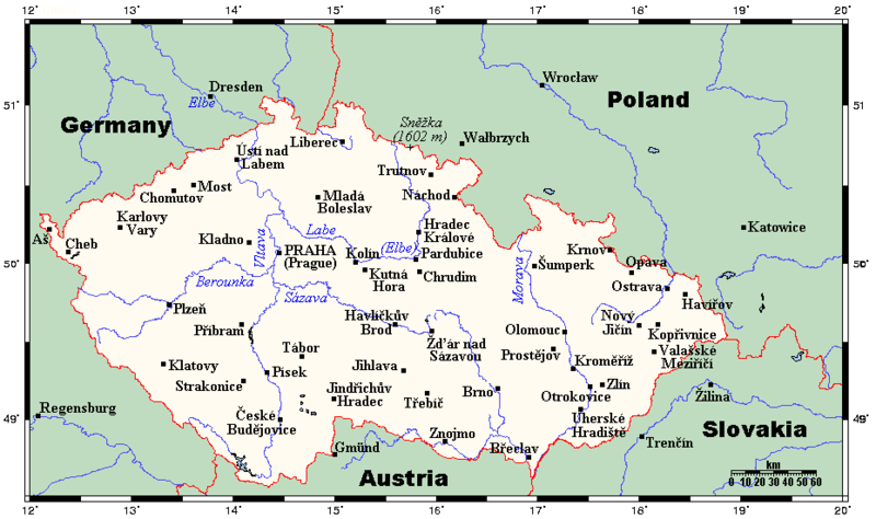
English: A map showing the Czech Republic's main cities and towns, and nearby areas in neighbouring countries. This map's source is here, with the uploader's modifications, and the GMT homepage says that the tools are released under the GNU General Public License. |
| Data | 2007ko uztailaren 26a (Jatorrizko igoera-data) |
| Jatorria | Transferred from en.wikipedia to Commons by Georgez. |
| Egilea | Kelisi at ingelesa Wikipedia |
Lizentzia
Kelisi from en.wikipedia.org, lan honen egileak, argitaratu du edo argitaratzen du ondorengo lizentzia pean:
| Fitxategi hau Creative Commons Attribution-Share Alike 3.0 Unported lizentziapean dago. Subject to disclaimers. | ||
| Aitortu: Kelisi from en.wikipedia.org | ||
| ||
| This licensing tag was added to this file as part of the GFDL licensing update. |

|
Baimena duzu dokumentu hau kopiatu, banatu edo/eta aldatzeko GNU Free Documentation License baldintzapean, Free Software Foundationek argitaratutako 1.2 edo ondorengo bertsioan; sekzio aldaezinik gabe, azaleko testurik gabe, eta atzeko azaleko testurik gabe. Lizentziaren kopia dago GNU Free Documentation License izenburudun atalean. Subject to disclaimers. |
Jatorrizko igoera erregistroa
The original description page was here. All following user names refer to en.wikipedia.
- 2007-07-26 22:40 Kelisi 930×551× (32250 bytes) oops
- 2007-07-26 22:38 Kelisi 930×551× (32273 bytes) Adding Sněžka.
- 2007-07-15 17:09 Kelisi 930×551× (31855 bytes) == Summary == A map showing the Czech Republic's main cities and towns, and nearby areas in neighbouring countries. This map's source is [http://www.aquarius.ifm-geomar.de/ here], with the uploader's modifications, and the [http://gmt.soest.hawaii.edu/ GM
Fitxategiaren historia
Data/orduan klik egin fitxategiak orduan zuen itxura ikusteko.
| Data/Ordua | Iruditxoa | Neurriak | Erabiltzailea | Iruzkina | |
|---|---|---|---|---|---|
| oraingoa | 19:21, 10 otsaila 2012 | | 930 × 551 (35 KB) | Miaow Miaow | added city of Opava |
| 18:15, 10 otsaila 2012 |  | 930 × 551 (32 KB) | Miaow Miaow | removed Líšeň (presumably a tongue-in-cheek addition by the original creator ?), which is merely a suburb of Brno and of much less importance than other cities depicted | |
| 17:57, 25 martxoa 2009 |  | 930 × 551 (31 KB) | Georgez | {{Information |Description={{en|A map showing the Czech Republic's main cities and towns, and nearby areas in neighbouring countries. This map's source is [http://www.aquarius.ifm-geomar.de/ here], with the uploader's modifications, and the [http://gmt.so |
Irudira dakarten loturak
Ez dago fitxategi hau darabilen orririk.
Fitxategiaren erabilera orokorra
Hurrengo beste wikiek fitxategi hau darabilte:
- ar.wikipedia.org proiektuan duen erabilera
- bs.wikipedia.org proiektuan duen erabilera
- el.wikipedia.org proiektuan duen erabilera
- en.wikipedia.org proiektuan duen erabilera
- ja.wikipedia.org proiektuan duen erabilera
- lt.wikipedia.org proiektuan duen erabilera
- mk.wikipedia.org proiektuan duen erabilera
- pt.wikipedia.org proiektuan duen erabilera