
Fitxategi:Daugava western dvina map.jpg
Aurreikuspen honen neurria: 649 × 599 pixel. Bestelako bereizmenak: 260 × 240 pixel | 520 × 480 pixel | 832 × 768 pixel | 1.276 × 1.178 pixel.
Bereizmen handikoa ((1.276 × 1.178 pixel, fitxategiaren tamaina: 254 KB, MIME mota: image/jpeg))
Fitxategi hau Wikimedia Commonsekoa da. Hango deskribapen orriko informazioa behean duzu. |

|
Irudi hau birsortu beharko litzateke SVG irudi bektorial moduan. Honek abantaila asko ematen ditu, ikus Commons:Media for cleanup (ingelesez) informazio gehiagorako. Irudi honen SVG bertsioa eskuragarri badago, mesedez Commonsera igo. Igo ostean, ordezkatu txantiloi hau txantiloi honegatik {{vector version available|irudiaren izen berria.svg}} irudi honetan.
|


Laburpena
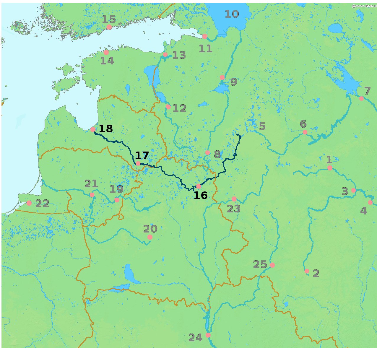
| Deskribapena | Map highlighting the river Daugava/Western Dvina (Daugava, Западная Двина́ (Zapadnaya Dvina), traditionally Дзвiна or newly Заходняя Дзвіна) flowing through Vitebsk (16), Daugavpils (17) and Riga (18). |
| Data | 2010ko martxoaren 13a, 17:59 (UTC) |
| Jatorria | |
| Egilea |
|
| This is a retouched picture, which means that it has been digitally altered from its original version. Modifications: Highlighted the Daugava river and cities it passes through. The original can be viewed here: LA2-Rivers of western Russia.png:
|
This image is in the public domain because it came from the site https://www.demis.nl/products/web-map-server/examples/ and was released by the copyright holder. Permission is granted to copy, distribute and/or modify this map since it is based on free of copyright images from: www.demis.nl. See also approval email on de.wp and its clarification.
|
| This work has been released into the public domain by its copyright holder, www.demis.nl. This applies worldwide. Estatu batzuetan beharbada hori ez da legez posible izango. Halakoetan: www.demis.nl grants anyone the right to use this work for any purpose, without any conditions, unless such conditions are required by law.
|
Jatorrizko igoera erregistroa
This image is a derivative work of the following images:
- File:LA2-Rivers_of_western_Russia.png licensed with PD-Demis
- 2008-05-20T22:30:46Z LA2 1274x1178 (269354 Bytes) {{Information |Description=Map of western Russia, with national borders marked (brown), rivers emphasized (dark blue) and major cities (pink) numbered (black). Bounding box West 19°, South 50°, East 40°, North 61°. Center
Uploaded with derivativeFX
Fitxategiaren historia
Data/orduan klik egin fitxategiak orduan zuen itxura ikusteko.
| Data/Ordua | Iruditxoa | Neurriak | Erabiltzailea | Iruzkina | |
|---|---|---|---|---|---|
| oraingoa | 19:59, 13 martxoa 2010 | | 1.276 × 1.178 (254 KB) | Alþykkr | {{Information |Description=Map highlighting the river Daugava/Western Dvina ({{lang-lv|Daugava}}, {{lang-ru|Западная Двина́ (Zapadnaya Dvina)}}, {{lang-be|traditionally Дзвiна or newly Заходняя Дзвіна}}, {{IPA2|zaˈxodnʲa |
Irudira dakarten loturak
Hurrengo orrialdeek dute fitxategi honetarako lotura:
Fitxategiaren erabilera orokorra
Hurrengo beste wikiek fitxategi hau darabilte:
- be-tarask.wikipedia.org proiektuan duen erabilera
- be.wikipedia.org proiektuan duen erabilera
- da.wikipedia.org proiektuan duen erabilera
- de.wikipedia.org proiektuan duen erabilera
- fr.wikipedia.org proiektuan duen erabilera
- pl.wikipedia.org proiektuan duen erabilera