
Fitxategi:Dipsacus fullonum MHNT.BOT.2005.0.269.jpg

Aurreikuspen honen neurria: 701 × 599 pixel. Bestelako bereizmenak: 281 × 240 pixel | 562 × 480 pixel | 898 × 768 pixel | 1.198 × 1.024 pixel | 2.396 × 2.048 pixel | 4.432 × 3.789 pixel.
Bereizmen handikoa ((4.432 × 3.789 pixel, fitxategiaren tamaina: 6,01 MB, MIME mota: image/jpeg))
Fitxategi hau Wikimedia Commonsekoa da. Hango deskribapen orriko informazioa behean duzu. |
|
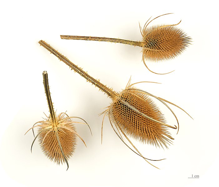
Dipsacus fullonum L., 1753 |
| Argazkilari | ||||||||||||||||||||||||
| Deskribapena |
Deutsch: Früchte am Ende der Laufzeit, von Wilde Karde English: Fruit at maturity, of Fuller's teasel. Français : Fruit à maturité de La Cardère sauvage. |
|||||||||||||||||||||||
| location of discovery | ||||||||||||||||||||||||
| Data | Taken on 2012ko abuztuaren 24a | |||||||||||||||||||||||
| Bilduma |
|
|||||||||||||||||||||||
| Erregistro-zenbakia |
MHNT.BOT.2005.0.969 |
|||||||||||||||||||||||
| Jatorria | Norberak egina | |||||||||||||||||||||||
| Lizentzia (Fitxategi hau berrerabiltzen) |
Nik, lan honen egileak, argitaratzen dut ondorengo lizentzia pean: This file is licensed under the Creative Commons Attribution-Share Alike 4.0 International license.
|
|||||||||||||||||||||||

| Kameraren kokapena | | Irudi hau eta gehiago beraien kokapenekin hurrengo lekuetan: OpenStreetMap |
|---|

|
This document was made as part of the Projet Phoebus.
|
Assessment
|

Fitxategiaren historia
Data/orduan klik egin fitxategiak orduan zuen itxura ikusteko.
| Data/Ordua | Iruditxoa | Neurriak | Erabiltzailea | Iruzkina | |
|---|---|---|---|---|---|
| oraingoa | 07:48, 24 abuztua 2012 | | 4.432 × 3.789 (6,01 MB) | Archaeodontosaurus | {{Information |Description ={{en|1=x}} |Source ={{own}} |Author =Archaeodontosaurus |Date = |Permission = |other_versions = }} |
Irudira dakarten loturak
Hurrengo orrialdeek dute fitxategi honetarako lotura:
Fitxategiaren erabilera orokorra
Hurrengo beste wikiek fitxategi hau darabilte:
- ast.wikipedia.org proiektuan duen erabilera
- ca.wikipedia.org proiektuan duen erabilera
- de.wikipedia.org proiektuan duen erabilera
- el.wikipedia.org proiektuan duen erabilera
- en.wikipedia.org proiektuan duen erabilera
- en.wiktionary.org proiektuan duen erabilera
- es.wikipedia.org proiektuan duen erabilera
- es.wiktionary.org proiektuan duen erabilera
- fr.wikipedia.org proiektuan duen erabilera
- fr.wiktionary.org proiektuan duen erabilera
- hsb.wikipedia.org proiektuan duen erabilera
- it.wikipedia.org proiektuan duen erabilera
- li.wikipedia.org proiektuan duen erabilera
- ml.wikipedia.org proiektuan duen erabilera
- nl.wikipedia.org proiektuan duen erabilera
- pt.wikipedia.org proiektuan duen erabilera
- ru.wikipedia.org proiektuan duen erabilera
- simple.wikipedia.org proiektuan duen erabilera
- sv.wikipedia.org proiektuan duen erabilera
- vi.wikipedia.org proiektuan duen erabilera