
Fitxategi:Downtown Detroit Street Circuit.svg

SVG fitxategi honen PNG aurreikuspenaren tamaina: 800 × 543 pixel. Bestelako bereizmenak: 320 × 217 pixel | 640 × 435 pixel | 1.024 × 696 pixel | 1.280 × 870 pixel | 2.560 × 1.739 pixel | 1.553 × 1.055 pixel.
Bereizmen handikoa (SVG fitxategia, nominaldi 1.553 × 1.055 pixel, fitxategiaren tamaina: 232 KB)
Fitxategi hau Wikimedia Commonsekoa da. Hango deskribapen orriko informazioa behean duzu. |
Laburpena
| Deskribapena |
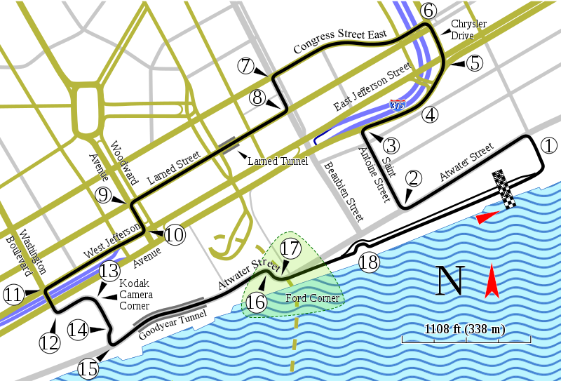
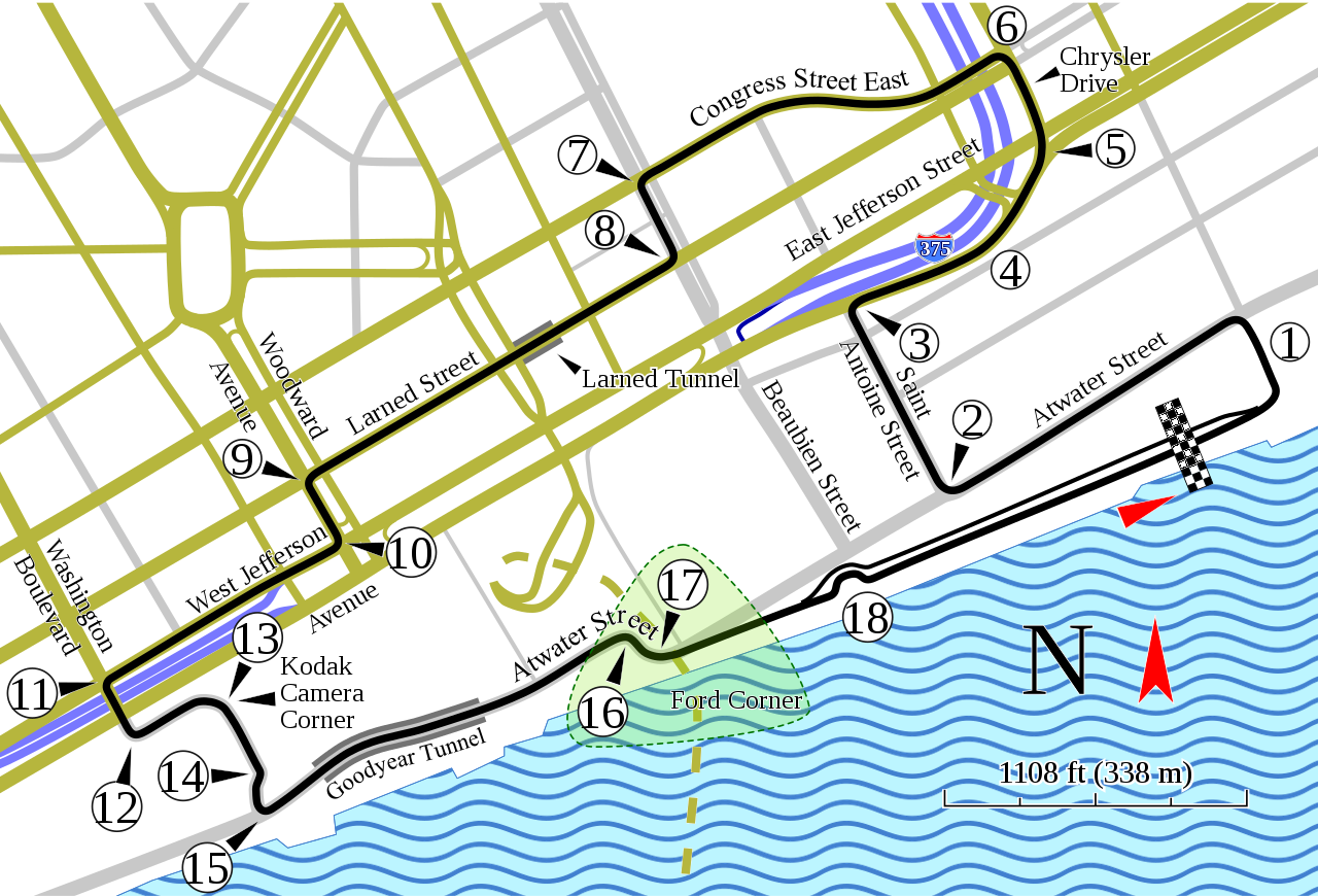
English: Track map of the former downtown Detroit street circuit. (Don't confuse this circuit with the one on Belle Isle.) |
| Data | |
| Jatorria | Norberak egina; Source for course information: "1982 F1 US Grand Prix of Detroit report: Watson takes victory". Motor Sport (July 1982): 43. Retrieved on 28 October 2019. |
| Egilea | Will Pittenger |
| Beste bertsioak |
|

| Kameraren kokapena | | Irudi hau eta gehiago beraien kokapenekin hurrengo lekuetan: OpenStreetMap |
|---|
Lizentzia
Fitxategi hau Creative Commons Attribution-Share Alike 3.0 Unported lizentziapean dago.
- Askea zara:
- partekatzeko – lana kopiatzeko, banatzeko eta bidaltzeko
- birnahasteko – lana moldatzeko
- Ondorengo baldintzen pean:
- eskuduntza – Egiletza behar bezala aitortu behar duzu, lizentzia ikusteko esteka gehitu, eta ea aldaketak egin diren aipatu. Era egokian egin behar duzu hori guztia, baina inola ere ez egileak zure lana edo zure erabilera babesten duela irudikatuz.
- berdin partekatu – Lan honetan oinarrituta edo aldatuta berria eraikitzen baduzu, emaitza lana hau bezalako lizentzia batekin argitaratu behar duzu.
Fitxategiaren historia
Data/orduan klik egin fitxategiak orduan zuen itxura ikusteko.
| Data/Ordua | Iruditxoa | Neurriak | Erabiltzailea | Iruzkina | |
|---|---|---|---|---|---|
| oraingoa | 17:56, 17 urtarrila 2016 | | 1.553 × 1.055 (232 KB) | Soisyc Croisic | Fixed Atwater street name |
| 10:57, 4 urria 2008 |  | 1.553 × 1.055 (236 KB) | Will Pittenger | Previous image had 3 text objects on paths. The current version of MediaWiki/RSVG hides such objects due to a bug. This version of the file gets around the bug by converting those objects into paths. If you need to edit the file, please use the old ver | |
| 10:53, 4 urria 2008 |  | 1.553 × 1.055 (172 KB) | Will Pittenger | All new image with more reference points to help orient readers. NOTE: New image, new license! | |
| 23:14, 2 urria 2008 |  | 1.534 × 994 (116 KB) | Will Pittenger | This version turns the text on path object that MediaWiki hides into a path. If you need to edit this file, please use the previous version. | |
| 23:13, 2 urria 2008 |  | 1.534 × 994 (89 KB) | Will Pittenger | New version fixes misspelling in "Chrysler". Note: a text object is on a path in this version. An upcoming version will convert that text object into a path. If you need to edit this file, please use this version. | |
| 13:43, 15 uztaila 2008 |  | 1.534 × 994 (114 KB) | Will Pittenger | New version gets around Mediawiki's bug in handling text on paths by converting that text to path objects. If you need to edit the file, please use the previous version. | |
| 13:38, 15 uztaila 2008 |  | 1.534 × 994 (61 KB) | Will Pittenger | {{Information |Description={{en|1=Track map of the former downtown w:Detroit street circuit. (Don't confuse this circuit with the one on w:Belle Isle.)}} |Source=Own work by uploader |Author=Will Pittenger |Date=7-15-200 |
Irudira dakarten loturak
Hurrengo orrialdeek dute fitxategi honetarako lotura:
Fitxategiaren erabilera orokorra
Hurrengo beste wikiek fitxategi hau darabilte:
- af.wikipedia.org proiektuan duen erabilera
- ast.wikipedia.org proiektuan duen erabilera
- bg.wikipedia.org proiektuan duen erabilera
- bn.wikipedia.org proiektuan duen erabilera
- cs.wikipedia.org proiektuan duen erabilera
- da.wikipedia.org proiektuan duen erabilera
- de.wikipedia.org proiektuan duen erabilera
- en.wikipedia.org proiektuan duen erabilera
- List of Formula One circuits
- 1982 Formula One World Championship
- 1983 Detroit Grand Prix
- 1984 Detroit Grand Prix
- Detroit street circuit
- Detroit Grand Prix (IndyCar)
- List of Champ Car circuits
- User talk:Chubbennaitor/archive2
- User talk:Barkjon/Archive 2
- Wikipedia:WikiProject Formula One/Newsletter/200808
- User talk:Hellboy2hell/archive2
- User talk:NapHit/Archive 1
- User talk:4u1e/archive5
- User talk:Typ932/Archive 3
- User talk:Midgrid/Archive 6
- User talk:Thelb4/Archive 5
- User talk:Chubbennaitor/Archive7
- Detroit Grand Prix
- User talk:Readro/Archive 3
- User talk:Donnie Park/Archive 1
- User talk:The359/Archive 4
- User talk:Cs-wolves/Archive 3
- User talk:Bam123456789/Archive 1
- 1985 Detroit Grand Prix
- 1986 Detroit Grand Prix
- 1987 Detroit Grand Prix
- User talk:Sage Callahan/Archive 1
- User talk:Cdhaptomos/Archive 1
- User:TorontoGuy79/sandbox
- User talk:Spenalzo/Archive/2008
- User talk:Clyde1998/Archive/2008
- es.wikipedia.org proiektuan duen erabilera
- et.wikipedia.org proiektuan duen erabilera
- fa.wikipedia.org proiektuan duen erabilera
- fr.wikipedia.org proiektuan duen erabilera
Ikus fitxategi honen erabilpen global gehiago.