
Fitxategi:Durrani Empire 1747 1862 AD.png
Aurreikuspen honen neurria: 768 × 600 pixel. Bestelako bereizmenak: 307 × 240 pixel | 615 × 480 pixel | 832 × 650 pixel.
Bereizmen handikoa ((832 × 650 pixel, fitxategiaren tamaina: 105 KB, MIME mota: image/png))
Fitxategi hau Wikimedia Commonsekoa da. Hango deskribapen orriko informazioa behean duzu. |
| Deskribapena |
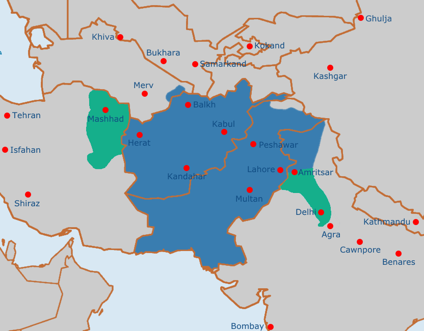
English: Map of the Afghan Durrani Empire at its greatest extent, circa late 1750s. In green is de facto (vassal) control. |
| Data | |
| Jatorria | https://en.wikipedia.org/wiki/File:Safavid_Empire_1501_1722_AD.png |
| Egilea | Arab Hafez and edited by me. |
This file is in the public domain because Released into the public domain by the author.
|
Fitxategiaren historia
Data/orduan klik egin fitxategiak orduan zuen itxura ikusteko.
| Data/Ordua | Iruditxoa | Neurriak | Erabiltzailea | Iruzkina | |
|---|---|---|---|---|---|
| oraingoa | 13:51, 4 abuztua 2021 | | 832 × 650 (105 KB) | Weaveravel | De facto/vessel control and corrected Mashhad/Khorasan |
| 13:39, 4 abuztua 2021 |  | 832 × 650 (108 KB) | Weaveravel | Improved map layout and scale, added Delhi territory (as de facto control), fixed cities geographical positions | |
| 20:54, 26 uztaila 2021 |  | 1.415 × 958 (205 KB) | Weaveravel | Clearer, high quality map, more accurate labels and cities (denoting important ones) | |
| 16:27, 28 apirila 2013 |  | 620 × 429 (22 KB) | HistoryofIran | {{subst:Upload marker added by en.wp UW}} {{Information |Description = {{en|Map of the Durrani Empire at it's greatest extent.}} |Source = https://en.wikipedia.org/wiki/File:Safavid_Empire_1501_1722_AD.png |Date = 28. April 2013. |Author = Arab Hafez a... |
Irudira dakarten loturak
Hurrengo orrialdeek dute fitxategi honetarako lotura:
Fitxategiaren erabilera orokorra
Hurrengo beste wikiek fitxategi hau darabilte:
- ar.wikipedia.org proiektuan duen erabilera
- ast.wikipedia.org proiektuan duen erabilera
- azb.wikipedia.org proiektuan duen erabilera
- az.wikipedia.org proiektuan duen erabilera
- bg.wikipedia.org proiektuan duen erabilera
- bn.wikipedia.org proiektuan duen erabilera
- bs.wikipedia.org proiektuan duen erabilera
- ca.wikipedia.org proiektuan duen erabilera
- cs.wikipedia.org proiektuan duen erabilera
- de.wikipedia.org proiektuan duen erabilera
- diq.wikipedia.org proiektuan duen erabilera
- el.wikipedia.org proiektuan duen erabilera
- en.wikipedia.org proiektuan duen erabilera
- eo.wikipedia.org proiektuan duen erabilera
- es.wikipedia.org proiektuan duen erabilera
- et.wikipedia.org proiektuan duen erabilera
- fa.wikipedia.org proiektuan duen erabilera
- fi.wikipedia.org proiektuan duen erabilera
- fr.wikipedia.org proiektuan duen erabilera
- he.wikipedia.org proiektuan duen erabilera
- hi.wikipedia.org proiektuan duen erabilera
- hu.wikipedia.org proiektuan duen erabilera
- hy.wikipedia.org proiektuan duen erabilera
- it.wikipedia.org proiektuan duen erabilera
- ka.wikipedia.org proiektuan duen erabilera
- kn.wikipedia.org proiektuan duen erabilera
- lt.wikipedia.org proiektuan duen erabilera
- mn.wikipedia.org proiektuan duen erabilera
- nl.wikipedia.org proiektuan duen erabilera
- nn.wikipedia.org proiektuan duen erabilera
- pt.wikipedia.org proiektuan duen erabilera
- ru.wikipedia.org proiektuan duen erabilera
- sk.wikipedia.org proiektuan duen erabilera
- sv.wikipedia.org proiektuan duen erabilera
- ta.wikipedia.org proiektuan duen erabilera
- tg.wikipedia.org proiektuan duen erabilera
- vi.wikipedia.org proiektuan duen erabilera
- www.wikidata.org proiektuan duen erabilera
Ikus fitxategi honen erabilpen global gehiago.