
Fitxategi:Easter Island map-en.svg

Bereizmen handikoa (SVG fitxategia, nominaldi 1.750 × 1.245 pixel, fitxategiaren tamaina: 878 KB)
Fitxategi hau Wikimedia Commonsekoa da. Hango deskribapen orriko informazioa behean duzu. |
Laburpena
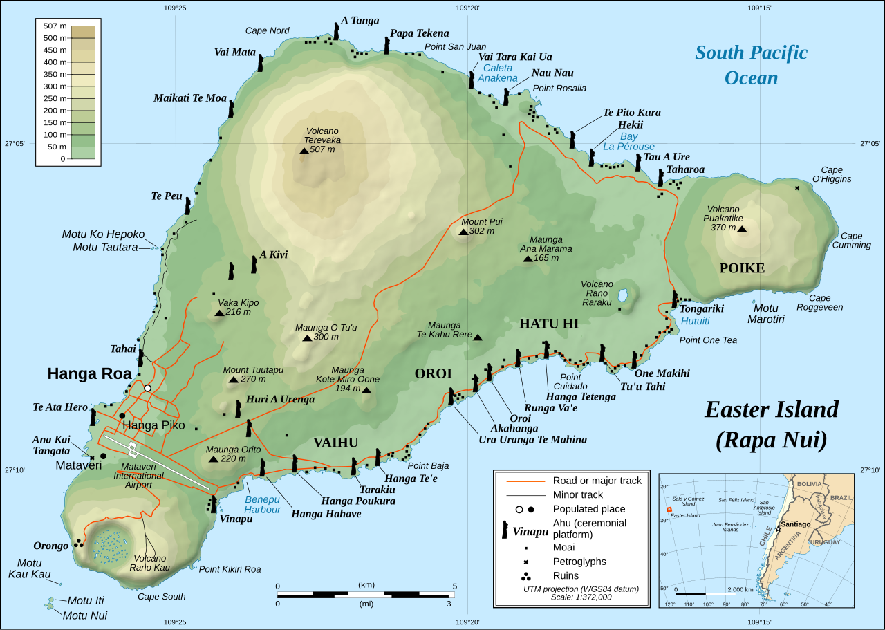
Irudi hau Eguneko irudi bezala hautatua izan da 2008ko abenduaren 1ea-(e)an. Honela izan zen deskribatua: English: Detailed topographic map in English of Easter Island. Beste hizkuntzak:
Afrikaans: Gedetaileerde topografie van Paaseiland Català: Mapa topogràfic detallat en anglès de l'Illa de Pasqua. Čeština: Detailní topografická mapa Velikonočního ostrova Eesti: Detailne inglisekeelne topograafiline kaart et:Lihavõttesaarest. English: Detailed topographic map in English of Easter Island. Esperanto: detala topografia mapo de la Paskinsulo (jen anglalingva, sed ankaŭ havebla en pluraj aliaj lingvoj) Français : Carte topographique détaillée en anglais de l'île de Pâques Italiano: Mappa topografica dell'Isola di Pasqua, Cile. Nederlands: Engelstalige gedetailleerde topografische kaart van Paaseiland Português: Mapa topográfico detalhado, em Inglês, da Ilha da Páscoa Română: Hartă topografică detaliată, în limba engleză, a insulei Paștelui. Svenska: Detaljerad topografisk karta på engelska över Påskön. Македонски: Детална топографска карта на Велигденскиот Остров на англиски. Русский: Топографическая карта Острова Пасхи 한국어: 이스터 섬의 지형도. 中文: 复活节岛地形图 中文(繁體): 復活節島地形圖 |
|

| Deskribapena |
English: Detailed topographic map in English of Easter Island
Français : Carte topographique détaillée en anglais de l'île de Paques
Português: Mapa topográfico detalhado, em Inglês, da Ilha da Páscoa.
|
| Data | October 2007 - October 2008 for the new version (see the release note) |
| Jatorria |
Own work
|
| Egilea | Eric Gaba (Sting), translated by Bamse |
| Lizentzia (Fitxategi hau berrerabiltzen) |
Creative Commons: Share Alike – attribution required |
| Beste bertsioak |
[]
|


![[1]](http://www.waymarker.co.uk/ml/rapanui/map.jpg)

|
SVG fitxategi honek Inkscape edo Adobe Illustrator bezalako SVG editore bat erabiliz erraz itzul daitekeen barneratutako testua du. Argibide gehiago. Nahi izanez gero, fitxategia jaitsi eta testu editore bat erabiliz ere itzul dezakezu. |
Lizentzia
- Askea zara:
- partekatzeko – lana kopiatzeko, banatzeko eta bidaltzeko
- birnahasteko – lana moldatzeko
- Ondorengo baldintzen pean:
- eskuduntza – Egiletza behar bezala aitortu behar duzu, lizentzia ikusteko esteka gehitu, eta ea aldaketak egin diren aipatu. Era egokian egin behar duzu hori guztia, baina inola ere ez egileak zure lana edo zure erabilera babesten duela irudikatuz.
- berdin partekatu – Lan honetan oinarrituta edo aldatuta berria eraikitzen baduzu, emaitza lana hau bezalako lizentzia batekin argitaratu behar duzu.
Fitxategiaren historia
Data/orduan klik egin fitxategiak orduan zuen itxura ikusteko.
| Data/Ordua | Iruditxoa | Neurriak | Erabiltzailea | Iruzkina | |
|---|---|---|---|---|---|
| oraingoa | 00:51, 12 urtarrila 2023 | | 1.750 × 1.245 (878 KB) | Tseng,Lu-Yen | Reverted to version as of 12:43, 22 October 2008 (UTC) |
| 09:17, 10 abendua 2011 |  | 1.750 × 1.245 (1,92 MB) | Hel-hama | Text appearance improved using Inkscape. | |
| 14:43, 22 urria 2008 |  | 1.750 × 1.245 (878 KB) | Sting | Completely new version of the map ; new standard colors | |
| 03:06, 30 urria 2007 |  | 1.750 × 1.245 (536 KB) | Sting | Some additional info | |
| 02:37, 19 urria 2007 |  | 1.750 × 1.245 (534 KB) | Bamse | ||
| 02:14, 19 urria 2007 |  | 1.750 × 1.245 (534 KB) | Bamse | {{Information |Description= |Source=self-made |Date= |Author= Bamse }} == Summary == {{Information| |Description=Detailed topographic map in English of Easter island |Source=Own work, translation of Image:Easter Island map-fr.svg<b |
Irudira dakarten loturak
Ez dago fitxategi hau darabilen orririk.
Fitxategiaren erabilera orokorra
Hurrengo beste wikiek fitxategi hau darabilte:
- af.wikipedia.org proiektuan duen erabilera
- ami.wikipedia.org proiektuan duen erabilera
- ar.wikipedia.org proiektuan duen erabilera
- az.wikipedia.org proiektuan duen erabilera
- bcl.wikipedia.org proiektuan duen erabilera
- bn.wikipedia.org proiektuan duen erabilera
- ca.wikipedia.org proiektuan duen erabilera
- ckb.wikipedia.org proiektuan duen erabilera
- da.wikipedia.org proiektuan duen erabilera
- de.wikipedia.org proiektuan duen erabilera
- el.wikipedia.org proiektuan duen erabilera
- en.wikipedia.org proiektuan duen erabilera
- Cartography
- Easter Island
- Hanga Roa
- Mu (mythical lost continent)
- Moai
- Motu Nui
- Map coloring
- Rapa Nui National Park
- Hanau epe
- Orongo
- Ahu Tongariki
- Poike
- Rano Kau
- Terevaka
- Ahu Akivi
- List of active separatist movements in Oceania
- User:ISaveNewspapers/sandbox
- Isla de Pascua (commune)
- Portal:Geodesy
- User:Iamojo/testcase/EasterIsland
- en.wikiversity.org proiektuan duen erabilera
- en.wikivoyage.org proiektuan duen erabilera
- es.wikipedia.org proiektuan duen erabilera
- et.wikipedia.org proiektuan duen erabilera
- fa.wikipedia.org proiektuan duen erabilera
- frr.wikipedia.org proiektuan duen erabilera
- fr.wikipedia.org proiektuan duen erabilera
- gl.wikipedia.org proiektuan duen erabilera
Ikus fitxategi honen erabilpen global gehiago.