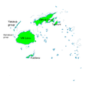
Fitxategi:Erythrura pealii map.png
Erythrura_pealii_map.png ((558 × 558 pixel, fitxategiaren tamaina: 55 KB, MIME mota: image/png))
Fitxategiaren historia
Data/orduan klik egin fitxategiak orduan zuen itxura ikusteko.
| Data/Ordua | Iruditxoa | Neurriak | Erabiltzailea | Iruzkina | |
|---|---|---|---|---|---|
| oraingoa | 08:20, 4 apirila 2011 |  | 558 × 558 (55 KB) | Jimfbleak | correction to Kadavu |
| 14:39, 30 martxoa 2011 |  | 558 × 558 (56 KB) | Jimfbleak | what happened there? | |
| 14:35, 30 martxoa 2011 |  | 558 × 558 (56 KB) | Jimfbleak | recaptioned | |
| 14:35, 30 martxoa 2011 |  | 558 × 558 (56 KB) | Jimfbleak | recaptioned | |
| 17:01, 11 martxoa 2011 |  | 558 × 558 (61 KB) | Jimfbleak | {{Information |Description=Distribution map of The Fiji Parrotfinch ''Erythrura pealii'' based on {{cite book || last = Watling | first = Dick | coauthors= | title = A Guide to the Birds of Fiji and Western Polynesia | year = 2003 | location = Tulani | pu |
Irudira dakarten loturak
Hurrengo orrialdeek dute fitxategi honetarako lotura:
Fitxategiaren erabilera orokorra
Hurrengo beste wikiek fitxategi hau darabilte:
- ar.wikipedia.org proiektuan duen erabilera
- arz.wikipedia.org proiektuan duen erabilera
- ast.wikipedia.org proiektuan duen erabilera
- bg.wikipedia.org proiektuan duen erabilera
- bn.wikipedia.org proiektuan duen erabilera
- ca.wikipedia.org proiektuan duen erabilera
- cs.wikipedia.org proiektuan duen erabilera
- cy.wikipedia.org proiektuan duen erabilera
- en.wikipedia.org proiektuan duen erabilera
- fa.wikipedia.org proiektuan duen erabilera
- fr.wikipedia.org proiektuan duen erabilera
- hu.wikipedia.org proiektuan duen erabilera
- it.wikipedia.org proiektuan duen erabilera
- no.wikipedia.org proiektuan duen erabilera
- pt.wikipedia.org proiektuan duen erabilera
- sv.wikipedia.org proiektuan duen erabilera
- ta.wikipedia.org proiektuan duen erabilera
- uk.wikipedia.org proiektuan duen erabilera
- vi.wikipedia.org proiektuan duen erabilera
- www.wikidata.org proiektuan duen erabilera
- zh.wikipedia.org proiektuan duen erabilera


