
Fitxategi:Europe map 1648-es.png

Aurreikuspen honen neurria: 800 × 577 pixel. Bestelako bereizmenak: 320 × 231 pixel | 640 × 462 pixel | 1.024 × 739 pixel | 1.280 × 924 pixel | 1.894 × 1.367 pixel.
Bereizmen handikoa ((1.894 × 1.367 pixel, fitxategiaren tamaina: 141 KB, MIME mota: image/png))
Fitxategi hau Wikimedia Commonsekoa da. Hango deskribapen orriko informazioa behean duzu. |
| Deskribapena |
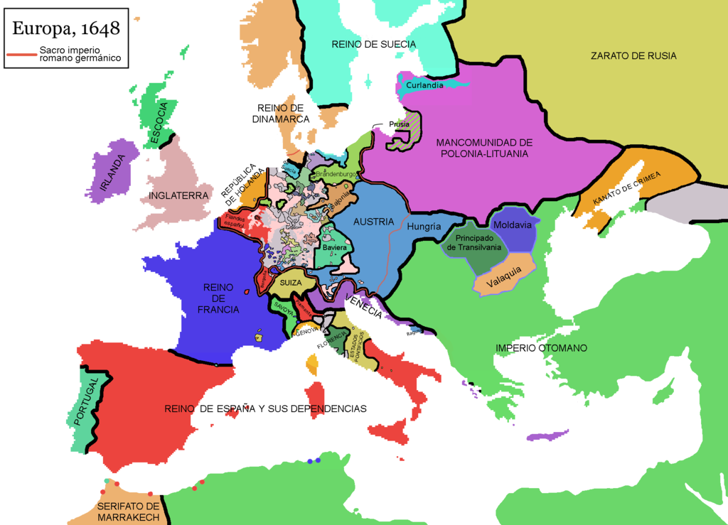
English: Map of Europe in 1648, at the end of the Thirty Years War. Red line marks the border of the Holy Roman Empire. (Labels in Spanish).
Español: Mapa de Europa en 1648, al final de la guerra de los treinta años. La línea roja marca las fronteras del Sacro imperio romano germánico.
Falta por cambiar el nombre de Piamonte, que es erroneo, la zona es el Milanesado o Ducado de Milan |
| Data | (UTC) |
| Jatorria | |
| Egilea |
|
| This is a retouched picture, which means that it has been digitally altered from its original version. Modifications: Rótulos en español (labels in Spanis) + Hungría. The original can be viewed here: Europe map 1648.PNG:
|
Nik, lan honen egileak, argitaratzen dut ondorengo lizentzia hauen pean:
| Fitxategi hau Creative Commons Attribution-Share Alike 3.0 Unported lizentziapean dago. | ||
| ||
| This licensing tag was added to this file as part of the GFDL licensing update. |

|
Baimena duzu dokumentu hau kopiatu, banatu edo/eta aldatzeko GNU Free Documentation License baldintzapean, Free Software Foundationek argitaratutako 1.2 edo ondorengo bertsioan; sekzio aldaezinik gabe, azaleko testurik gabe, eta atzeko azaleko testurik gabe. Lizentziaren kopia dago GNU Free Documentation License izenburudun atalean. |
Nahiago duzun lizentzia erabil dezakezu.
Jatorrizko igoera erregistroa
This image is a derivative work of the following images:
- File:Europe_map_1648.PNG licensed with Cc-by-sa-3.0-migrated, GFDL
- 2010-09-25T11:40:35Z Fakirbakir 1894x1367 (197540 Bytes) Minor
- 2010-09-25T10:45:19Z Fakirbakir 1894x1367 (197532 Bytes) Transylvania Moldavia and Wallachia were a 'semi-independent' state under the suzerainty of the Ottoman Empire.
- 2008-12-12T02:13:45Z Mathiasrex 1894x1367 (197990 Bytes) In 1648 Duchy of Prussia was yet a fief of the Polish Crown
- 2008-11-04T22:12:11Z Beliar 1894x1367 (197454 Bytes) Holstein was part of the HRE but was ruled by the danish king in personal union as the duce of H.
- 2007-10-24T07:09:47Z Conscious 1894x1367 (186157 Bytes) "Tsardom of Russia" instead of "Russian Empire" (this is a pre-1721 map)
- 2007-01-10T05:47:14Z Roke 1894x1367 (186110 Bytes) more detail HRE, fixes
- 2006-06-08T00:10:58Z Roke 1894x1367 (186146 Bytes) change to polish-lithuanian commonwealth after comment on en
- 2006-05-09T09:08:45Z Roke 1894x1367 (184339 Bytes) cropped right version
- 2006-05-08T13:12:58Z Roke 1894x1374 (111881 Bytes) minor crop
- 2006-05-05T05:12:47Z Roke 1900x1378 (185935 Bytes) Map of Europe in 1648 (at the end of the [[w:Thirty Years War|Thirty Years War]], based on free map of europe [[:Image:BlankMap-Europe.png]] {{Europe}} [[Category:Historical maps of Europe]]
Uploaded with derivativeFX
Fitxategiaren historia
Data/orduan klik egin fitxategiak orduan zuen itxura ikusteko.
| Data/Ordua | Iruditxoa | Neurriak | Erabiltzailea | Iruzkina | |
|---|---|---|---|---|---|
| oraingoa | 13:48, 10 azaroa 2017 | | 1.894 × 1.367 (141 KB) | Raderich | Corregidos algunos errores en el mapa. |
| 17:52, 9 iraila 2017 |  | 1.894 × 1.367 (134 KB) | Daniel Medina | Corregidas algunas erratas heredadas de la imagen original en inglés de 2010 en base a la versión de 2017 de la misma imagen (Media:Europe_map_1648.PNG. Concretamente se añaden: • la anexión de Cataluña por parte de Francia • enclaves f... | |
| 16:23, 3 maiatza 2013 |  | 1.894 × 1.367 (121 KB) | Osado | Label improvement; Burgundia → Borgoña | |
| 16:15, 3 maiatza 2013 |  | 1.894 × 1.367 (150 KB) | Osado | Reverted to version as of 11:31, 4 August 2011 | |
| 11:57, 2 maiatza 2013 |  | 1.894 × 1.367 (121 KB) | Osado | Label improvement; Burgundia → Borgoña | |
| 13:31, 4 abuztua 2011 |  | 1.894 × 1.367 (150 KB) | Osado | {{Information |Description={{en|Map of Europe in 1648, at the end of the Thirty Years War. Red line marks the border of the Holy Roman Empire. (Labels in Spanish).}} {{es|Mapa de Europa en 1648, al final de la guerra de los treinta años. La línea roja m |
Irudira dakarten loturak
Hurrengo orrialdeek dute fitxategi honetarako lotura:
Fitxategiaren erabilera orokorra
Hurrengo beste wikiek fitxategi hau darabilte:
- ast.wikipedia.org proiektuan duen erabilera
- es.wikipedia.org proiektuan duen erabilera
- es.wikibooks.org proiektuan duen erabilera
- pt.wikipedia.org proiektuan duen erabilera
- www.wikidata.org proiektuan duen erabilera
- wuu.wikipedia.org proiektuan duen erabilera