
Fitxategi:FallingwaterCantilever570320cv.jpg
Bereizmen handikoa ((967 × 674 pixel, fitxategiaren tamaina: 221 KB, MIME mota: image/jpeg))
Fitxategi hau Wikimedia Commonsekoa da. Hango deskribapen orriko informazioa behean duzu. |
Laburpena
| Deskribapena |
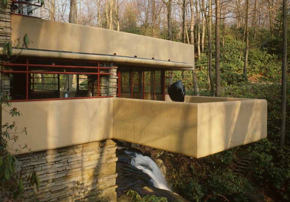
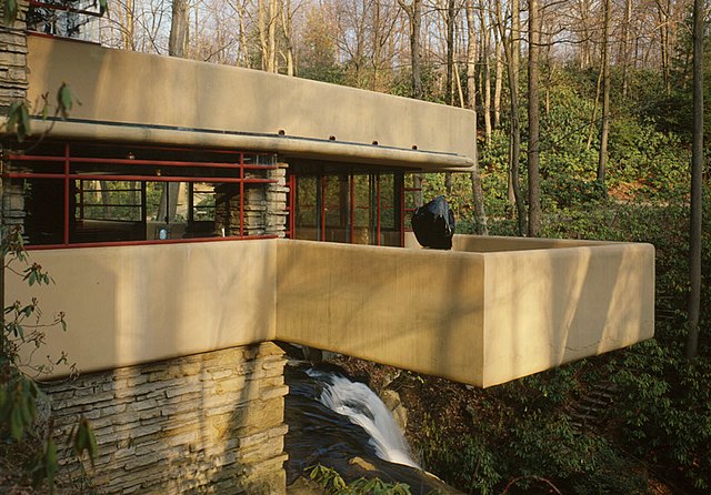
English: Frank Lloyd Wright, Fallingwater, State Route 381 (Stewart Township), Ohiopyle vicinity, Fayette County, PA - Detail of west living room terrace over crest of waterfall. |
|||||
| Data | ||||||
| Jatorria |
Library of Congress, Prints and Photographs Division, Historic American Buildings Survey: PA,26-OHPY.V,1-90 |
|||||
| Egilea | Jack E Boucher, HABS staff photographer | |||||
| Lizentzia (Fitxategi hau berrerabiltzen) |
|

| Objektuaren kokapena | | Irudi hau eta gehiago beraien kokapenekin hurrengo lekuetan: OpenStreetMap |
|---|

|
This image is available from the United States Library of Congress's Prints and Photographs division
under the digital ID hhh.pa1690. This tag does not indicate the copyright status of the attached work. A normal copyright tag is still required. See Commons:Licensing.
|
Fitxategiaren historia
Data/orduan klik egin fitxategiak orduan zuen itxura ikusteko.
| Data/Ordua | Iruditxoa | Neurriak | Erabiltzailea | Iruzkina | |
|---|---|---|---|---|---|
| oraingoa | 21:07, 4 apirila 2009 | | 967 × 674 (221 KB) | Cropbot | upload cropped version, operated by User:Finavon. Summary: border cropped |
| 11:19, 12 apirila 2006 |  | 1.024 × 733 (235 KB) | Frode Inge Helland | Frank Lloyd Wright, Fallingwater |
Irudira dakarten loturak
Hurrengo orrialdeek dute fitxategi honetarako lotura:
Fitxategiaren erabilera orokorra
Hurrengo beste wikiek fitxategi hau darabilte:
- ar.wikipedia.org proiektuan duen erabilera
- ast.wikipedia.org proiektuan duen erabilera
- bn.wikipedia.org proiektuan duen erabilera
- ca.wikipedia.org proiektuan duen erabilera
- ckb.wikipedia.org proiektuan duen erabilera
- da.wikipedia.org proiektuan duen erabilera
- de.wikipedia.org proiektuan duen erabilera
- en.wikipedia.org proiektuan duen erabilera
- es.wikipedia.org proiektuan duen erabilera
- fa.wikipedia.org proiektuan duen erabilera
- gl.wikipedia.org proiektuan duen erabilera
- he.wikipedia.org proiektuan duen erabilera
- hy.wikipedia.org proiektuan duen erabilera
- id.wikipedia.org proiektuan duen erabilera
- lv.wikipedia.org proiektuan duen erabilera
- ml.wikipedia.org proiektuan duen erabilera
- no.wikipedia.org proiektuan duen erabilera
- pl.wiktionary.org proiektuan duen erabilera
- pt.wikipedia.org proiektuan duen erabilera
- ro.wikipedia.org proiektuan duen erabilera
- ru.wikipedia.org proiektuan duen erabilera
- sl.wikipedia.org proiektuan duen erabilera
- sr.wikipedia.org proiektuan duen erabilera
- tr.wikipedia.org proiektuan duen erabilera
- uk.wikipedia.org proiektuan duen erabilera
- zh.wikipedia.org proiektuan duen erabilera