Fitxategi:First century Iudaea province.gif
Orriaren edukia ez da onartzen beste hizkuntza batzuetan.
Wikipedia, Entziklopedia askea

Bereizmen handikoa((575 × 792 pixel, fitxategiaren tamaina: 31 KB, MIME mota: image/gif))

Fitxategi hau Wikimedia Commonsekoa da. Hango deskribapen orriko informazioa behean duzu.
Commons gordailu bat da, lizentzia askea duten multimedia fitxategiena. Lagun dezakezu.

Fitxategi hau Wikimedia Commonsekoa da
Irudi hau birsortu beharko litzateke SVG irudi bektorial moduan. Honek abantaila asko ematen ditu, ikus Commons:Media for cleanup (ingelesez) informazio gehiagorako. Irudi honen SVG bertsioa eskuragarri badago, mesedez Commonsera igo. Igo ostean, ordezkatu txantiloi hau txantiloi honegatik {{vector version available|irudiaren izen berria.svg}} irudi honetan.

Laburpena

Deskribapena
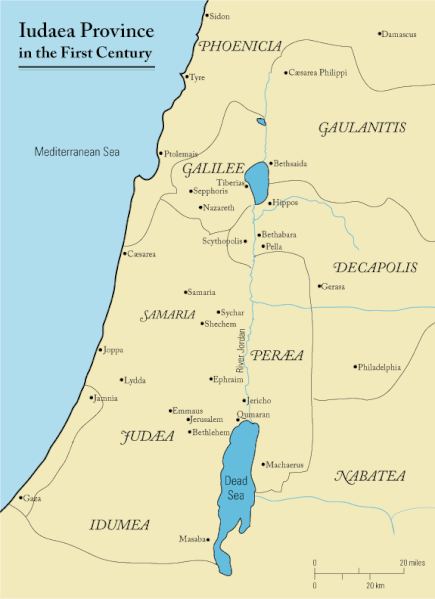
English: This is a map of first century Iudaea Province that I created using Illustrator CS2. I traced this image for the general geographic features. I then manually input data from maps found in a couple of sources.
  • Robert W. Funk and the Jesus Seminar. The Acts of Jesus. HarperSanFrancisco: 1998. p. xxiv.
  • Michael Grant. Jesus: An Historian's Review of the Gospels. Charles Scribner's Sons: 1977. p. 65-67.
  • John P. Meier. A Marginal Jew. Doubleday: 1991. p. 1:434.
Data 2006ko martxoaren 23a (Jatorrizko igoera-data)
Jatorria Transferred from en.wikipedia to Commons.
Egilea Andrew c at ingelesa Wikipedia
Lizentzia
(Fitxategi hau berrerabiltzen)
Released under the GNU Free Documentation License or CC-BY.
Beste bertsioak العربيَّة

Lizentzia

Andrew c from en.wikipedia.org, lan honen egileak, argitaratu du edo argitaratzen du ondorengo lizentzia pean:
GNU head Baimena duzu dokumentu hau kopiatu, banatu edo/eta aldatzeko GNU Free Documentation License baldintzapean, Free Software Foundationek argitaratutako 1.2 edo ondorengo bertsioan; sekzio aldaezinik gabe, azaleko testurik gabe, eta atzeko azaleko testurik gabe. Lizentziaren kopia dago GNU Free Documentation License izenburudun atalean. Subject to disclaimers.
w:eu:Creative Commons
eskuduntza
Fitxategi hau Creative Commons Aitortu 3.0 Unported lizentziaren mende dago.
Aitortu: Wikipedia User:Andrew c
Askea zara:
  • partekatzeko – lana kopiatzeko, banatzeko eta bidaltzeko
  • birnahasteko – lana moldatzeko
Ondorengo baldintzen pean:
  • eskuduntza – Egiletza behar bezala aitortu behar duzu, lizentzia ikusteko esteka gehitu, eta ea aldaketak egin diren aipatu. Era egokian egin behar duzu hori guztia, baina inola ere ez egileak zure lana edo zure erabilera babesten duela irudikatuz.
Public domain Nik, lan honen egile eskubideen jabeak, lan hau domeinu publikoan jartzen dut. Mundu osoan du eragina honek.
Estatu batzuetan beharbada hori ez da legez posible izango. Halakoetan:
Edonori ematen diot lan hau edozertarako erabiltzeko eskubidea, inolako baldintzarik gabe, legeak nahitaez ezarritako baldintzak izan ezik.

Jatorrizko igoera erregistroa

The original description page was here. All following user names refer to en.wikipedia.
  • 2006-03-24 18:48 Andrew c 575×792×8 (32374 bytes) This is a map of First Century Palestine that I created using Illustrator CS2. I traced [http://commons.wikimedia.org/wiki/Image:Map_of_administrative_regions_in_Israel.png this] image for the general geographic features. I then manually input data from m
  • 2006-03-23 19:48 Andrew c 587×790×8 (30752 bytes) This is a map of First Century Palestine that I created using Illustrator CS2. I traced [http://commons.wikimedia.org/wiki/Image:Map_of_administrative_regions_in_Israel.png this] image for the general geographic features. I then manually input data from m

Irudi-oineko testuak

Add a one-line explanation of what this file represents
Judaea province in the 1st Century CE

Fitxategi honetan agertzen diren itemak

honako hau irudikatzen du

23 martxoa 2006

MIME type ingelesa

image/gif

checksum ingelesa

e488e0183049d2138c916ccc7a24c107807f12b7

data size ingelesa

32.019 Byte

792 pixel

575 pixel

Fitxategiaren historia

Data/orduan klik egin fitxategiak orduan zuen itxura ikusteko.

Data/OrduaIruditxoaNeurriakErabiltzaileaIruzkina
oraingoa13:47, 18 iraila 201113:47, 18 iraila 2011 bertsioaren iruditxoa575 × 792 (31 KB)OnceinawhileRemoved region-name "Philistia", as incorrect
16:05, 13 iraila 200716:05, 13 iraila 2007 bertsioaren iruditxoa575 × 792 (32 KB)Liftarn{{SVG|map}} {{Information |Description=This is a map of first century en:Iudaea Province that I created using Illustrator CS2. I traced [http://commons.wikimedia.org/wiki/Image:Map_of_administrative_regions_in_Israel.png this] image for the general g
02:29, 30 apirila 200602:29, 30 apirila 2006 bertsioaren iruditxoa575 × 792 (32 KB)Duende~commonswikihttp://en.wikipedia.org/wiki/Image:First_century_palestine.gif

Hurrengo orrialdeek dute fitxategi honetarako lotura:

Fitxategiaren erabilera orokorra

Hurrengo beste wikiek fitxategi hau darabilte:

Ikus fitxategi honen erabilpen global gehiago.