
Fitxategi:Gallia Cisalpina-fr.svg

Bereizmen handikoa (SVG fitxategia, nominaldi 949 × 717 pixel, fitxategiaren tamaina: 822 KB)
Fitxategi hau Wikimedia Commonsekoa da. Hango deskribapen orriko informazioa behean duzu. |
Laburpena
| Deskribapena |
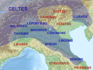
English: Map of Cisalpine Gaul.
Français : Carte de la Gaule cisalpine et de l'emplacement approximatif des peuples qui l'habitaient et des peuples voisins.
Italiano: Distribuzione approssimata delle popolazioni della Gallia Cisalpina.
|
||||
| Data | |||||
| Jatorria |
Fitxategi hau hemendik eratorria izan da: |
||||
| Egilea |
|
||||
| Beste bertsioak |
[]
| ||||
| Aitortu (required by the license) | © Sémhur / Wikimedia Commons / | ||||
| SVG | W3C-validity not checked. Fitxategi hau (bektore-irudia) hau Inkscape-ekin sortu da .
.
|
||||
| Graphic Lab |


| Kameraren kokapena | | Irudi hau eta gehiago beraien kokapenekin hurrengo lekuetan: OpenStreetMap |
|---|
Lizentzia
| Copyleft: This work of art is free; you can redistribute it and/or modify it according to terms of the Free Art License. You will find a specimen of this license on the Copyleft Attitude site as well as on other sites. |
- Askea zara:
- partekatzeko – lana kopiatzeko, banatzeko eta bidaltzeko
- birnahasteko – lana moldatzeko
- Ondorengo baldintzen pean:
- eskuduntza – Egiletza behar bezala aitortu behar duzu, lizentzia ikusteko esteka gehitu, eta ea aldaketak egin diren aipatu. Era egokian egin behar duzu hori guztia, baina inola ere ez egileak zure lana edo zure erabilera babesten duela irudikatuz.
- berdin partekatu – Lan honetan oinarrituta edo aldatuta berria eraikitzen baduzu, emaitza lana hau bezalako lizentzia batekin argitaratu behar duzu.
Jatorrizko igoera erregistroa
This image is a derivative work of the following images:
- File:Gallia_cisalpina.jpg licensed with GFDL, GFDL-user-w
- 2010-05-22T09:04:55Z GaiusCrastinus 732x550 (473321 Bytes) {{Information |Description=Map of Cisalpine Gaul |Source=[http://it.wikipedia.org/wiki/File:Gallia_cisalpina.jpg] |Date= |Author=Xoil |Permission= |other_versions= }} {{GFDL-user-w|projectcode|Wikipedia|Xoil}} [[Category:M
- File:Italy_topographic_map-ancient_Roman_roads.svg licensed with Cc-by-sa-3.0, GFDL
- 2012-06-27T17:17:18Z Flappiefh 1587x1833 (1830617 Bytes) Réduction de la surface affichée pour se concentrer sur le territoire de l'Italie.
- 2012-06-27T14:58:16Z Flappiefh 1759x2167 (1829252 Bytes) {{Information |Description ={{fr|1=Carte topographique représentant les principales voies romaines construites en Italie sous l'Empire Romain.}} |Source =Based on a [[:File:Italy topographic map-blank.svg|Topograp
Uploaded with derivativeFX
Fitxategiaren historia
Data/orduan klik egin fitxategiak orduan zuen itxura ikusteko.
| Data/Ordua | Iruditxoa | Neurriak | Erabiltzailea | Iruzkina | |
|---|---|---|---|---|---|
| oraingoa | 22:56, 31 abuztua 2013 | | 949 × 717 (822 KB) | Sémhur | == {{int:filedesc}} == {{Information |Description={{Multilingual description/start}} {{en|1= Map of Cisalpine Gaul.}} {{fr|1= Carte de la fr:Gaule cisalpine et de l'emplacement approximatif des peuples qui l'habitaient et des peuples voisins.}} {... |
Irudira dakarten loturak
Hurrengo orrialdeek dute fitxategi honetarako lotura:
Fitxategiaren erabilera orokorra
Hurrengo beste wikiek fitxategi hau darabilte:
- af.wikipedia.org proiektuan duen erabilera
- bg.wikipedia.org proiektuan duen erabilera
- br.wikipedia.org proiektuan duen erabilera
- ca.wikipedia.org proiektuan duen erabilera
- el.wikipedia.org proiektuan duen erabilera
- en.wikipedia.org proiektuan duen erabilera
- et.wikipedia.org proiektuan duen erabilera
- fa.wikipedia.org proiektuan duen erabilera
- fr.wikipedia.org proiektuan duen erabilera
- Sénons
- Liste des peuples celtes
- Lingons
- Gaule cisalpine
- Celtes d'Italie
- Marcus Claudius Marcellus (consul en -222)
- Senigallia
- Raids gaulois en Italie
- Tombe à char du monde celtique
- Caius Cornelius Cethegus (consul en -197)
- Culture de Golasecca
- Wikipédia:Atelier graphique/Cartes/Archives/septembre 2013
- Tombe de Ca' Morta
- Modèle:Palette Culture de Golasecca
- Mediolanum
- Inscription de Prestino
- Tombe du deuxième guerrier de Sesto Callende
- Utilisateur:Ruyblas13/Constructions et essais/archive 2016/1
- he.wikipedia.org proiektuan duen erabilera
- it.wikipedia.org proiektuan duen erabilera
- lij.wikipedia.org proiektuan duen erabilera
- nl.wikipedia.org proiektuan duen erabilera
- no.wikipedia.org proiektuan duen erabilera
- oc.wikipedia.org proiektuan duen erabilera
- pt.wikipedia.org proiektuan duen erabilera
- ru.wikipedia.org proiektuan duen erabilera