
Fitxategi:Guadeloupe Places of interest map-fr.svg

SVG fitxategi honen PNG aurreikuspenaren tamaina: 776 × 600 pixel. Bestelako bereizmenak: 311 × 240 pixel | 621 × 480 pixel | 994 × 768 pixel | 1.280 × 989 pixel | 2.560 × 1.978 pixel | 2.200 × 1.700 pixel.
Bereizmen handikoa (SVG fitxategia, nominaldi 2.200 × 1.700 pixel, fitxategiaren tamaina: 1,79 MB)
Fitxategi hau Wikimedia Commonsekoa da. Hango deskribapen orriko informazioa behean duzu. |
Laburpena
| Deskribapena | |||
| Data | |||
| Jatorria |
travail personnel (own work).
Data sources:
Softwares used:
Others:
|
||
| Egilea | Sémhur | ||
| Beste bertsioak |
| ||
| Aitortu (required by the license) | © Sémhur / Wikimedia Commons / | ||
| SVG | W3C-validity not checked. Fitxategi hau (bektore-irudia) hau Inkscape-ekin sortu da .
.
|
||
| Graphic Lab |


| Kameraren kokapena | | Irudi hau eta gehiago beraien kokapenekin hurrengo lekuetan: OpenStreetMap |
|---|
Lizentzia
Nik, lan honen egileak, argitaratzen dut ondorengo lizentzia hauen pean:
| Copyleft: This work of art is free; you can redistribute it and/or modify it according to terms of the Free Art License. You will find a specimen of this license on the Copyleft Attitude site as well as on other sites. |
This file is licensed under the Creative Commons Attribution-Share Alike 4.0 International, 3.0 Unported, 2.5 Generic, 2.0 Generic and 1.0 Generic license.
- Askea zara:
- partekatzeko – lana kopiatzeko, banatzeko eta bidaltzeko
- birnahasteko – lana moldatzeko
- Ondorengo baldintzen pean:
- eskuduntza – Egiletza behar bezala aitortu behar duzu, lizentzia ikusteko esteka gehitu, eta ea aldaketak egin diren aipatu. Era egokian egin behar duzu hori guztia, baina inola ere ez egileak zure lana edo zure erabilera babesten duela irudikatuz.
- berdin partekatu – Lan honetan oinarrituta edo aldatuta berria eraikitzen baduzu, emaitza lana hau bezalako lizentzia batekin argitaratu behar duzu.
Nahiago duzun lizentzia erabil dezakezu.
Fitxategiaren historia
Data/orduan klik egin fitxategiak orduan zuen itxura ikusteko.
| Data/Ordua | Iruditxoa | Neurriak | Erabiltzailea | Iruzkina | |
|---|---|---|---|---|---|
| oraingoa | 19:05, 7 azaroa 2022 | | 2.200 × 1.700 (1,79 MB) | Antimuonium | moved Porte d'Enfer to its actual position |
| 21:29, 5 martxoa 2009 |  | 2.200 × 1.700 (1,79 MB) | Sémhur | Orthograph: Marie-Galanzte => Marie-Galante | |
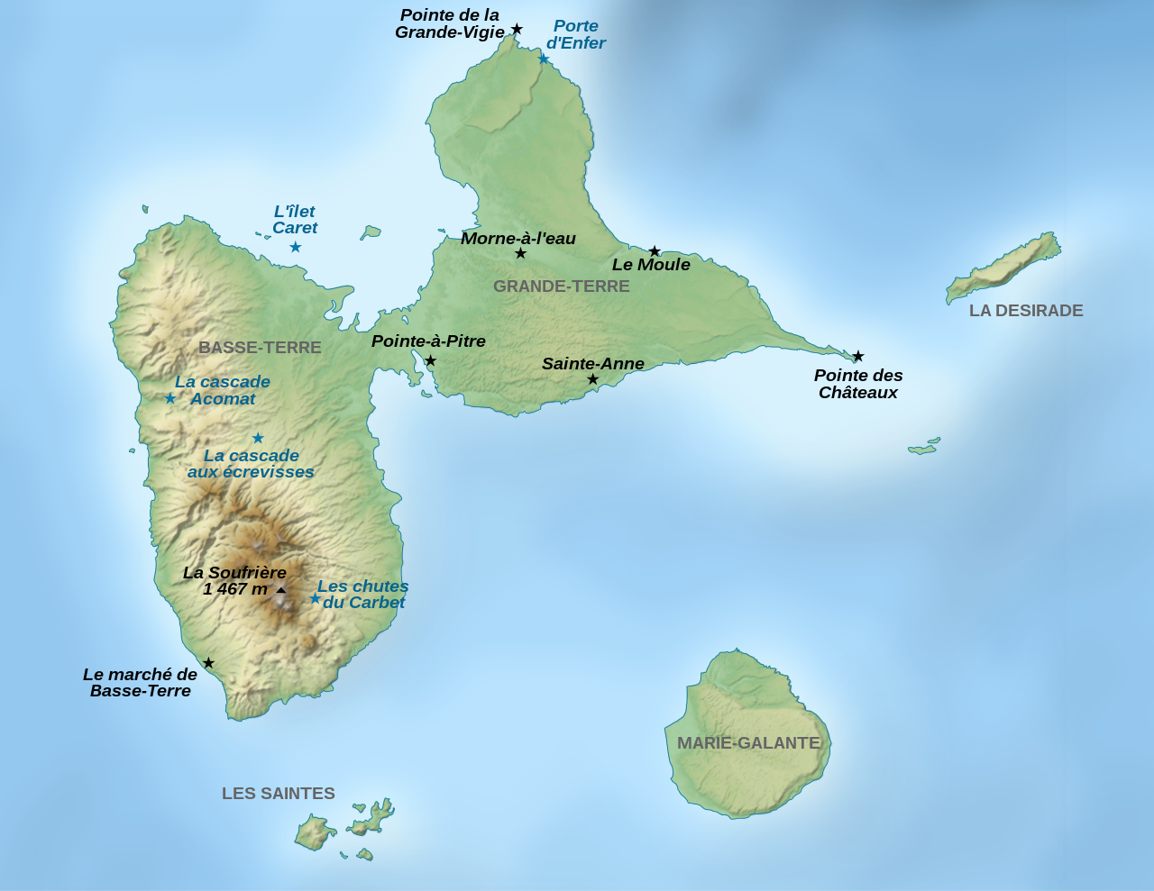
| 15:11, 25 iraila 2008 |  | 2.200 × 1.700 (1,79 MB) | Sémhur | == Description == {{Information |Description= {{en|1=Map of places of interest in Guadeloupe, a French archipelago in the Antilles.}} {{fr|1=Carte de lieux touristiques de Guadeloupe, un archipel fran |
Irudira dakarten loturak
Ez dago fitxategi hau darabilen orririk.
Fitxategiaren erabilera orokorra
Hurrengo beste wikiek fitxategi hau darabilte:
- als.wikipedia.org proiektuan duen erabilera
- en.wikipedia.org proiektuan duen erabilera
- es.wikipedia.org proiektuan duen erabilera
- fr.wikipedia.org proiektuan duen erabilera
- gl.wikipedia.org proiektuan duen erabilera
- hu.wikipedia.org proiektuan duen erabilera
- nl.wikipedia.org proiektuan duen erabilera
- ro.wikipedia.org proiektuan duen erabilera