
Fitxategi:Rita 2005-09-21 1610Z.jpg

Bereizmen handikoa ((6.400 × 8.000 pixel, fitxategiaren tamaina: 9,48 MB, MIME mota: image/jpeg))
Fitxategi hau Wikimedia Commonsekoa da. Hango deskribapen orriko informazioa behean duzu. |
Laburpena
| Deskribapena |
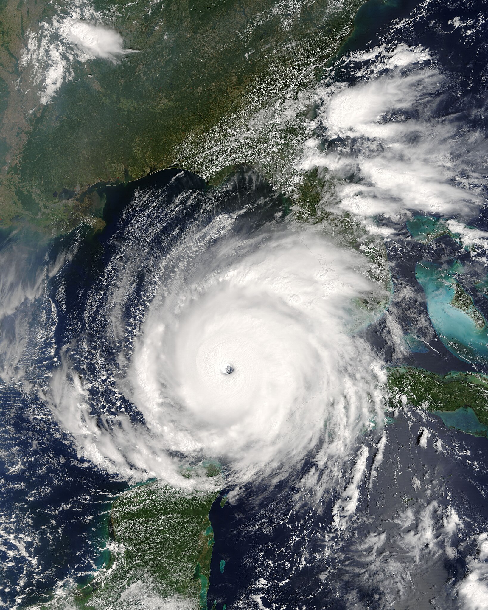
English: Rita was building into an extremely dangerous Category 5 hurricane when the ’ on NASA’s Terra satellite captured this image at 12:10 p.m., U.S. Eastern time on September 21, 2005. The storm bears the markings of a powerful hurricane: it is compact and circular, with an open eye through which the deep blue waters of the Gulf of Mexico are visible. At the time this image was acquired, Rita had winds of 220 kilometers per hour (140 miles per hour) with gusts to 270 kph (170 mph). Within a few hours, the storm intensified to a Category 5 hurricane with sustained winds of 265 kph (165 mph).
Rita is the thrird Category 5 storm of the 2005 Atlantic hurricane season. The first was Hurricane Katrina, which devastated much of the Mississippi, Louisiana, and Alabama shoreline when it came ashore on August 29. Rita is expected to weaken slightly before coming ashore over the Texas or Louisiana coastline on September 23 or 24 as a major hurricane (Category 3 or higher). In this photo-like image, the Gulf Coast of the United States frames the open water to the north, while the Yucatan Peninsula is visible to the south. MODIS detected several fires, marked with red dots, burning in the southeastern United States. The fires are probably agricultural fires.Suomi: Hurrikaani Rita lähestymässä Meksikonlahden länsiosaa 21. syyskuuta |
|||||
| Data | ||||||
| Jatorria | http://visibleearth.nasa.gov/view_rec.php?id=7957 | |||||
| Egilea | Jacques Descloitres, MODIS Rapid Response Team, NASA/GSFC | |||||
| Lizentzia (Fitxategi hau berrerabiltzen) |
|

Fitxategiaren historia
Data/orduan klik egin fitxategiak orduan zuen itxura ikusteko.
| Data/Ordua | Iruditxoa | Neurriak | Erabiltzailea | Iruzkina | |
|---|---|---|---|---|---|
| oraingoa | 18:29, 26 abuztua 2006 | | 6.400 × 8.000 (9,48 MB) | Good kitty | |
| 00:29, 22 iraila 2005 |  | 3.200 × 4.000 (3,25 MB) | Holderca1~commonswiki | Hurricane Rita near peak intensity as it churns across the Gulf of Mexico, taking aim at the Texas coast. ==Source/Credit== http://earthobservatory.nasa.gov/NaturalHazards/natural_hazards_v2.php3?img_id=13146 NASA image courtesy Jeff Schmaltz, MODIS Lan |
Irudira dakarten loturak
Hurrengo orrialdeek dute fitxategi honetarako lotura:
Fitxategiaren erabilera orokorra
Hurrengo beste wikiek fitxategi hau darabilte:
- ar.wikipedia.org proiektuan duen erabilera
- ca.wikipedia.org proiektuan duen erabilera
- de.wikipedia.org proiektuan duen erabilera
- en.wikipedia.org proiektuan duen erabilera
- User:Jdorje/2005 Atlantic hurricane season/2005 Atlantic hurricane season storms
- User:Omni ND/Good Pictures
- Portal:Tropical cyclones/Anniversaries/September
- Portal:Tropical cyclones/Anniversaries/September/24
- Climate of Beaumont, Texas
- Wikipedia:Featured picture candidates/March-2008
- Wikipedia:Featured picture candidates/HurricaneRita21Sept05a.jpg
- Portal:Tropical cyclones/Selected image/29
- Wikipedia:Featured picture candidates/Hurricane Rita
- User:Cyclonebiskit/Hurricane Rita
- User:DaBloonsplayer
- User:SuperNascar 1991
- User:Grammarguruguy
- User:40bus/sandbox1
- Portal:Tropical cyclones/Selected image
- en.wikinews.org proiektuan duen erabilera
- Hurricane Dennis makes landfall on Gulf Coast near Pensacola
- Mandatory evacuation declared in New Orleans, US
- Template:Hurricane 2005 Infobox
- Template talk:2005 Hurrican Season Infobox
- Template talk:Hurricane 2005 Infobox
- At least 55 killed by Hurricane Katrina; serious flooding across affected region
- Blackwater mercenaries used in New Orleans
- Hurricane Ophelia hits U.S. East Coast
- Tropical Storm Wilma forms, ties record for busiest hurricane season
- Hurricane Wilma becomes stronger on its path toward Florida
- Hurricane Wilma still a Category 5 threat
- Florida Governor Jeb Bush gives speech on Hurricane Wilma
- Tropical Storm Epsilon forms as 2005 Atlantic hurricane season comes to an end
- Tropical Storm Zeta becomes second cross-season tropical storm in history
- Record-breaking 2005 Atlantic Hurricane Season officially ends
- eo.wikipedia.org proiektuan duen erabilera
- es.wikipedia.org proiektuan duen erabilera
- fa.wikipedia.org proiektuan duen erabilera
- fi.wikipedia.org proiektuan duen erabilera
- fr.wikipedia.org proiektuan duen erabilera
- he.wikipedia.org proiektuan duen erabilera
- hu.wikipedia.org proiektuan duen erabilera
- it.wikipedia.org proiektuan duen erabilera
- ko.wikipedia.org proiektuan duen erabilera
- nl.wikipedia.org proiektuan duen erabilera
- pl.wikipedia.org proiektuan duen erabilera
- pt.wikipedia.org proiektuan duen erabilera
Ikus fitxategi honen erabilpen global gehiago.