
Fitxategi:ISS-38 Southern Patagonian Ice Field.jpg

Aurreikuspen honen neurria: 800 × 532 pixel. Bestelako bereizmenak: 320 × 213 pixel | 640 × 426 pixel | 1.024 × 681 pixel | 1.280 × 852 pixel | 2.560 × 1.703 pixel | 4.256 × 2.832 pixel.
Bereizmen handikoa ((4.256 × 2.832 pixel, fitxategiaren tamaina: 1,2 MB, MIME mota: image/jpeg))
Fitxategi hau Wikimedia Commonsekoa da. Hango deskribapen orriko informazioa behean duzu. |
Laburpena
| Deskribapena |
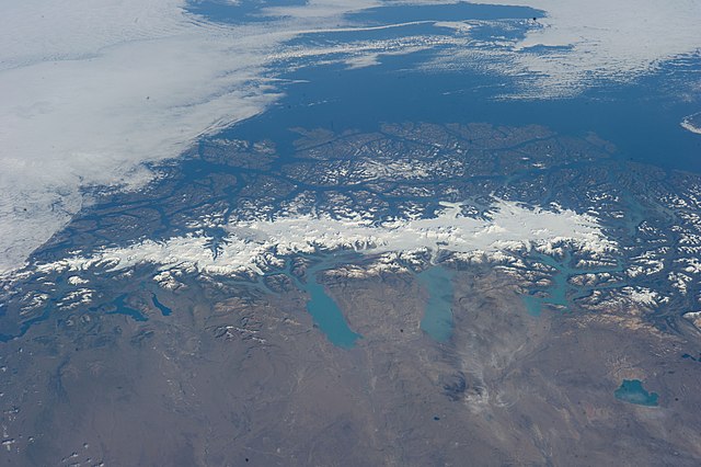
English: This grand panorama of the Southern Patagonia Icefield (center) was imaged by an Expedition 38 crew member on the International Space Station on one of the rare clear days in the southern Andes Mountains.
|
| Data | |
| Jatorria | https://www.flickr.com/photos/nasa2explore/12905018565/ |
| Egilea | NASA |
This image or video was catalogued by Johnson Space Center of the United States National Aeronautics and Space Administration (NASA) under Photo ID: ISS038-E-047324. This tag does not indicate the copyright status of the attached work. A normal copyright tag is still required. See Commons:Licensing. Other languages:
|
Lizentzia
This file is in the public domain in the United States because it was created by the Image Science & Analysis Laboratory, of the NASA Johnson Space Center. NASA copyright policy states that "NASA material is not protected by copyright unless noted". (NASA media use guidelines or Conditions of Use of Astronaut Photographs).
Photo source: ISS038-E-047324.
|
Fitxategiaren historia
Data/orduan klik egin fitxategiak orduan zuen itxura ikusteko.
| Data/Ordua | Iruditxoa | Neurriak | Erabiltzailea | Iruzkina | |
|---|---|---|---|---|---|
| oraingoa | 03:47, 27 ekaina 2014 | | 4.256 × 2.832 (1,2 MB) | Ras67 | == {{int:filedesc}} == {{Information |Description={{en|1=This grand panorama of the Southern Patagonia Icefield (center) was imaged by an Expedition 38 crew member on the International Space Station on one of the rare clear days in the southern Andes M... |
Irudira dakarten loturak
Hurrengo orrialdeek dute fitxategi honetarako lotura:
Fitxategiaren erabilera orokorra
Hurrengo beste wikiek fitxategi hau darabilte:
- ast.wikipedia.org proiektuan duen erabilera
- ca.wikipedia.org proiektuan duen erabilera
- cs.wikipedia.org proiektuan duen erabilera
- en.wikipedia.org proiektuan duen erabilera
- es.wikipedia.org proiektuan duen erabilera
- fr.wikipedia.org proiektuan duen erabilera
- it.wikipedia.org proiektuan duen erabilera
- www.wikidata.org proiektuan duen erabilera