
Fitxategi:Japan satellite view with Kii Peninsula marked.png

Aurreikuspen honen neurria: 658 × 600 pixel. Bestelako bereizmenak: 263 × 240 pixel | 527 × 480 pixel | 843 × 768 pixel | 1.124 × 1.024 pixel | 1.557 × 1.419 pixel.
Bereizmen handikoa ((1.557 × 1.419 pixel, fitxategiaren tamaina: 1,26 MB, MIME mota: image/png))
Fitxategi hau Wikimedia Commonsekoa da. Hango deskribapen orriko informazioa behean duzu. |
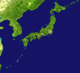
| Deskribapena | Satellite view of Japan with the Kii Peninsula marked. |
| Data | |
| Jatorria |
|
| Egilea |
|
| Beste bertsioak | Derivative works of this file: Kikai location on japan map.jpg |
| This is a retouched picture, which means that it has been digitally altered from its original version. The original can be viewed here: Japan satellite.jpg:
|
| This file is in the public domain in the United States because it was solely created by NASA. NASA copyright policy states that "NASA material is not protected by copyright unless noted". (See Template:PD-USGov, NASA copyright policy page or JPL Image Use Policy.) | ||
 |
Warnings:
|
Jatorrizko igoera erregistroa
This image is a derivative work of the following images:
- File:Japan_satellite.jpg licensed with PD-USGov-NASA
- 2005-08-19T08:04:26Z っ 1557x1419 (971852 Bytes) source: http://visibleearth.nasa.gov/images/2433/land_shallow_topo_21600.tif {{PD-USGov-NASA}}
Fitxategiaren historia
Data/orduan klik egin fitxategiak orduan zuen itxura ikusteko.
| Data/Ordua | Iruditxoa | Neurriak | Erabiltzailea | Iruzkina | |
|---|---|---|---|---|---|
| oraingoa | 07:35, 16 apirila 2009 | | 1.557 × 1.419 (1,26 MB) | Nihonjoe | {{Information |Description=Satellite view of Japan with the Kii Peninsula marked. |Source=*Japan_satellite.jpg based on [http://visibleearth.nasa.gov/images/2433/land_shallow_topo_21600.tif this image] |
Irudira dakarten loturak
Hurrengo orrialdeek dute fitxategi honetarako lotura:
Fitxategiaren erabilera orokorra
Hurrengo beste wikiek fitxategi hau darabilte:
- ar.wikipedia.org proiektuan duen erabilera
- az.wikipedia.org proiektuan duen erabilera
- hr.wikipedia.org proiektuan duen erabilera
- id.wikipedia.org proiektuan duen erabilera
- it.wikipedia.org proiektuan duen erabilera
- ko.wikipedia.org proiektuan duen erabilera
- nl.wikipedia.org proiektuan duen erabilera
- ru.wikipedia.org proiektuan duen erabilera
- tr.wikipedia.org proiektuan duen erabilera
- www.wikidata.org proiektuan duen erabilera